
Larchant | |
|---|---|
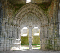
 The basilica of Saint Mathurin | |
Location of Larchant  | |
 Larchant  Larchant | |
| Coordinates: 48°17′06″N 2°35′51″E / 48.285°N 2.5975°E | |
| Country | France |
| Region | Île-de-France |
| Department | Seine-et-Marne |
| Arrondissement | Fontainebleau |
| Canton | Nemours |
| Government | |
| • Mayor (2020–2026) | Vincent Mevel[1] |
| Area 1 | 29.24 km2 (11.29 sq mi) |
| Population (Jan. 2021)[2] | 713 |
| • Density | 24/km2 (63/sq mi) |
| Time zone | UTC+01:00 (CET) |
| • Summer (DST) | UTC+02:00 (CEST) |
| INSEE/Postal code | 77244 /77760 |
| Elevation | 62–141 m (203–463 ft) |
| 1 French Land Register data, which excludes lakes, ponds, glaciers > 1 km2 (0.386 sq mi or 247 acres) and river estuaries. | |
Larchant (French pronunciation: [laʁʃɑ̃] ⓘ) is a commune in the Seine-et-Marne department in the Île-de-France region. It is located on the southern edge of the Forest of Fontainebleau.
YouTube Encyclopedic
-
1/3Views:1 2881 303308
-
L'hivernale de Larchant 2014
-
Visite de la basilique Saint-Mathurin de Larchant
-
La Basilica di Saint Mathurin a Larchant (Ile-de-France)
Transcription
Demographics
The inhabitants are called Liricantois from the Latin name of the town, Liricantus.
The 1793 census showed a population of 470 people and the maximum population was 730 in 1841.[3] The national statistical authority put the 2020 population at 697 people. The same source shows that 69% of the dwellings were occupied by full time residents, while 20% were second homes and 11% were vacant.[4]
History

Prehistory. In the immediate vicinity of Larchant, around 100 caves contain extensive displays of prehistoric, mostly geometric etchings (e.g. lattices).[5] Of particular note is the vast 'Painted Cave' (la grotte de la peinture). Still visible on its ceiling are traces of an ochre-colored cave painting. Also visible are numerous etchings that have been reliably dated to the Mesolithic period.[6]
The Gallic period. During the Gallic period, Larchant was a spiritual sanctuary dedicated to the cult of water. The destruction and abandonment of the sanctuary is thought to have taken place sometime between AD 350 and 378.[7]

The Middle Ages. The Middle Ages witnessed the development of Larchant as an important pilgrimage destination. It served as the center of the cult of Saint Mathurin and attracted, in particular, pilgrims seeking cures for madness or exorcism for the possessed.[8] Pilgrims heading for Santiago de Compostela also often stopped at Larchant.[9] Starting in 1324, the pilgrimage was flourishing to such an extent that it generated funds that were used to finance the operation of Notre Dame de Paris (which had received Larchant as donation from Elisabeth Le Riche in the early 11th century). The growing influx of pilgrims required the construction of the larger church which still dominates the village. With the French Revolution, the pilgrimage largely disappeared, though remnants exist to this day.
The built environment
Larchant's rich spiritual and religious history has left it with an impressive architectural heritage. Key features include:
The basilica of Saint Mathurin. Not technically a basilica, this partly ruined church was built in several stages between the 12th and the 16th century. The structure has suffered numerous vicissitudes over the ages, including pillage and arson during the War of Religions, and several natural disasters. In 1675, the northeast pillar of the high tower collapsed into the nave.[10] In 1846, the church was designated as a monument historique by the French Ministry of Culture.[11]

The ferme du Chapitre. Overlooking Larchant, this medieval agricultural complex features a tithing barn, dovecote and well. It was the base from which the canons of the 'chapitre' of Notre Dame de Paris looked after their economic interests in Larchant, after receiving the village as a donation in the 11th century. This arrangement ended with the French Revolution.[10]
Saint Mathurin's source (Fontaine Saint Mathurin). A site thought to be linked to the ancient cult of water and to the origins of the village of Larchant and also closely linked to the veneration of Saint Mathurin. According to tradition, Mathurin was a shepherd and, in order to provide water for his flock, he brought forth a spring by kicking a rock which still bears the imprint of his foot.
The Inn of the Three Kings (L'auberge des Trois Rois). This structure has a 15th-century facade and is the best conserved of what was, at the time of the pilgrimages to the tomb of Saint Mathurin, one of many inns available to pilgrims.
The ‘Calvary of the Three Crosses’ (Le Calvaire des trois croix). Dated to at least the 12 century (and possibly much earlier), the base of the Calvaire takes the form of an octagonal pyramid with 8 faces and 7 levels. At the top of the structure are four relatively easily identifiable heads of a toad, a hare, a turtle and a sheep. Originally, the base supported 4 columns.[12] The Calvary is located on the outskirts of the village, just off the road to the Dame Jouanne
The natural environment

Larchant benefits from a rich natural heritage, including biologically significant wetlands and the Fontainebleau forest.
The Larchant Wetlands Nature Preserve (la Réserve Naturelle Régionale du Marais de Larchant) covers about 124 hectares (306 acres) and supports an exceptional level of biodiversity — 480 plant species and 145 species of beetle have been identified in the reserve. The reserve also offers one of the most important bird sanctuaries in the Île de France region.[13]
The Forest of Fontainebleau (and specifically the area referred to as the Forest of the Commanderie, a reference to an ancient Templar site) almost completely surrounds Larchant.[14] It is a mixed deciduous forest and has a total area of 250 square kilometres (97 square miles). Particularly in the area around Larchant, the forest is known for its very pure and fine sand and for its striking, zoomorphic boulders in sandstone (grès de Fontainebleau).[15]
Cultural references and other features

A landscape oil painting by Balthus dating from 1939 is a panoramic view of the village centered on the basilica.[16]
In her 1980 novel The Boy Who Followed Ripley, Patricia Highsmith described the town as a "quiet village" where "[t]he little private houses, all close together in cobble-stoned lanes, looked like illustrations from children's books, cottages almost too small for man and wife to live in".[17]
Larchant is renowned for its first-class boulder climbing sites, l'Éléphant and la Dame Jouanne, in the Forêt de la Commanderie that surrounds it.[18]
Gallery
-
 The apse of the Basilica
 -
 Detail of North portal of the Basilica
 -
 North portal of the Basilica, with tympanum illustrating the Last Judgment.
 -
 The dovecote of the Farm of the Chapitre
 -
 The interior of the dovecote
 -
 Broader view of the Farm of the Chapitre
 -
 Inn of the 3 Kings
 -
 The Pilgrim's Lodge
 -
 The Calvary of the Three Crosses. Le Calvaire des trois croix.


See also
- Communes of the Seine-et-Marne department
- Fontainebleau rock climbing
- Basilica of Saint Mathurin
- Prehistoric rock engravings of the Fontainebleau Forest
References
- ^ "Répertoire national des élus: les maires" (in French). data.gouv.fr, Plateforme ouverte des données publiques françaises. 13 September 2022.
- ^ "Populations légales 2021". The National Institute of Statistics and Economic Studies. 28 December 2023.
- ^ Des villages de Cassini aux communes d'aujourd'hui: Commune data sheet Larchant, EHESS (in French).
- ^ Institut National de la Statistique et des Etudes Economiques. "Logement en 2020: Commune de Larchant". INSEE. Retrieved 22 January 2024.
- ^ Benard A et Guéret C. "Les abris ornés du mésolithique du sud de l'Ile de France". Palenthnology Open Edition Journal. Retrieved February 3, 2021.
- ^ Guéret, Colas; Bénard, Alain (2017-06-01). ""Fontainebleau rock art" (Ile-de-France, France), an exceptional rock art group dated to the Mesolithic? Critical return on the lithic material discovered in three decorated rock shelters". Journal of Archaeological Science: Reports. 13: 99–120. doi:10.1016/j.jasrep.2017.03.039. ISSN 2352-409X.
- ^ Rousselle, Aline (1990). Croire et guérir. La foi en Gaule dans l'Antiquité tardive. Fayard.
- ^ Association Culturelle de Larchant. "Le pèlerinage sur le tombeau du saint". Association Culturelle Larchant. Retrieved December 13, 2020.
- ^ Dulin, Priscille (1995). "Le pèlerinage de saint Mathurin de Larchant: aspects spirituels et matériels". Mémoire de maîtrise d'histoire; Université Paris X- Nanterre.
- ^ a b Verdier, Marc (1969). L'église Saint-Mathurin de Larchant. Amis des Monuments et Sites de Seine-Maritime.
- ^ Base Mérimée: Eglise Saint-Mathurin, Ministère français de la Culture. (in French)
- ^ "Calvaire des trois croix | Association Culturelle de Larchant" (in French). Retrieved 2021-02-22.
- ^ Seine et Marne. "La Réserve Naturelle Régionale du Marais de Larchant". Seine et Marne.
- ^ Seine et Marne. "La Forêt Domaniale de la Commanderie". Seine et Marne. Retrieved February 3, 2021.
- ^ USEP94. "Le sable et le grès de Fontainebleau" (PDF). USEP94. Retrieved February 3, 2021.
{{cite web}}: CS1 maint: numeric names: authors list (link) - ^ Rewald, Sabine (1984). Balthus. Metropolitan Museum of Art. pp. 96–7. ISBN 9780810907386. Retrieved May 24, 2015.
- ^ Highsmith, Patricia (1980). The Boy who Followed Ripley. Lippincott & Crowell. ISBN 9780393332117. Retrieved May 25, 2015.
- ^ "Site d'escalade Fontainebleau (L'éléphant) - info, topo, localisation..." climbingaway.fr. Retrieved 2019-07-01.
External links
- Official site (in French)
- 1999 Land Use, from IAURIF (Institute for Urban Planning and Development of the Paris-Île-de-France région) (in English)
- French Ministry of Culture list for Larchant (in French)
| International | |
|---|---|
| National | |