
Heilbronn | |
|---|---|
 Flag 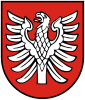 Coat of arms | |
 | |
| Country | Germany |
| State | Baden-Württemberg |
| Adm. region | Stuttgart |
| Capital | Heilbronn |
| Government | |
| • District admin. | Norbert Heuser |
| Area | |
| • Total | 1,099.59 km2 (424.55 sq mi) |
| Population (31 December 2022)[1] | |
| • Total | 353,283 |
| • Density | 320/km2 (830/sq mi) |
| Time zone | UTC+01:00 (CET) |
| • Summer (DST) | UTC+02:00 (CEST) |
| Vehicle registration | HN |
| Website | www |
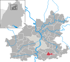
Landkreis Heilbronn (German pronunciation: [haɪlˈbʁɔn] ⓘ) is a Landkreis (district) in the north of Baden-Württemberg, Germany. Neighboring districts are (from north clockwise) Neckar-Odenwald, Hohenlohe, Schwäbisch Hall, Rems-Murr, Ludwigsburg, Enz, Karlsruhe and Rhein-Neckar. In the centre of it is the free-city of Heilbronn, which is its own separate administrative area.
History
The predecessor to the district is the Oberamt Heilbronn, which was created in 1803 when the previously Free Imperial City of Heilbronn was incorporated into the Electorate of Württemberg. In 1926, about half of the Oberamt (old district) of Weinsberg was added. In 1938, it was recognized as a district, and in addition to the previous Oberamt, parts of the dissolved Oberämter Neckarsulm, Brackenheim, Marbach and Besigheim were added. The city of Heilbronn was not included in the district. In 1973, the Landkreise (districts) were reorganized, and part of the dissolved districts of Sinsheim, Mosbach, Buchen and Schwäbisch Hall were added. Within the following two years 5 municipalities were incorporated into the city and therefore left the district, which got its current borders in 1975.
Geography
The main river in the district is the Neckar, which flows through the district from the south to the north. The western part of the district belongs to the landscape Kraichgau, the east to the Hohenloher Ebene, Kocher-Jagst-Ebene, and the Löwensteiner Berge.
Coat of arms
The coat of arms shows a clawless eagle, the symbol of the Counts of Lauffen, who ruled the area of the district in the 13th century.
Towns and municipalities
Towns (Städte):
Municipalities (Gemeinden):
- Abstatt
- Cleebronn
- Eberstadt
- Ellhofen
- Erlenbach (Württemberg)
- Flein
- Gemmingen
- Hardthausen (Kocher)
- Ilsfeld
- Ittlingen
- Jagsthausen
- Kirchardt
- Langenbrettach
- Lehrensteinsfeld
- Massenbachhausen
- Neckarwestheim
- Nordheim (Württemberg)
- Obersulm
- Oedheim
- Offenau
- Pfaffenhofen
- Roigheim
- Siegelsbach
- Talheim
- Untereisesheim
- Untergruppenbach
- Wüstenrot
- Zaberfeld
Municipal associations (Vereinbarte Verwaltungsgemeinschaften and Gemeindeverwaltungsverbände):
- Bad Friedrichshall
- Bad Rappenau
- Brackenheim
- Eppingen
- Flein-Talheim
- Lauffen
- Möckmühl
- Neckarsulm
- Neuenstadt
- Oberes Zabergäu
- Obersulm
- Schozach-Bottwartal
- Schwaigern
- Raum Weinsberg
References
- ^ "Bevölkerung nach Nationalität und Geschlecht am 31. Dezember 2022" [Population by nationality and sex as of December 31, 2022] (CSV) (in German). Statistisches Landesamt Baden-Württemberg. June 2023.
External links
- Official website (German)

| International | |
|---|---|
| National | |
49°10′N 9°15′E / 49.16°N 9.25°E