
Lae Nadzab Airport | |||||||||||
|---|---|---|---|---|---|---|---|---|---|---|---|
 | |||||||||||
| Summary | |||||||||||
| Airport type | Public | ||||||||||
| Elevation AMSL | 238 ft / 72.5 m | ||||||||||
| Coordinates | 6°34′11″S 146°43′34″E / 6.56972°S 146.72611°E | ||||||||||
| Map | |||||||||||
 Lae Nadzab Airport  Lae Nadzab Airport | |||||||||||
| Runways | |||||||||||
| |||||||||||
Officially named Nadzab Tomodachi International Airport,[1] Nadzab Airport is a regional airport located at Nadzab 42 kilometres (26 mi) outside Lae, Morobe Province, Papua New Guinea along the Highlands Highway. It is served by both private and regional aircraft with domestic flights. The airport replaced the Lae Airfield in 1977.
Nadzab is located on the Erap River, 5 kilometres (3.1 mi) North of the Markham River. The settlements of Gabmatsung/Gabmatzung and Gabsonkek are located on the East side of the airport.[2]
YouTube Encyclopedic
-
1/5Views:3494985902 282316
-
Aircraft movements Lae 1981
-
Flying into Lae
-
Whatever happened to the Old Lae Airport?
-
Flight POM to LAE Landing at Lae Nadzab Airport
-
Landing at Nadzab - Wikipedia article
Transcription
History
In about 1910 the Gabmatsung/Gabmazung Lutheran mission station was established at Nadzab.[3] and established an airfield for use by small planes until the outbreak of the Pacific War when it became overgrown with dense kunai grass.[4]

World War II
In March 1942, the Japanese occupied Lae and Salamaua.
Between April 1943 and July 1943, the Allied Geographical Section of South West Pacific Area (command) conducted reconnaissance after the Japanese invasion. The Terrain Handbook states at page 18:
Nazdab is located twenty-seven miles NW of Lae by road 900 yds by an indefinite width. Covered with kunai grass. Good dispersal area. Emergency landing ground for heavy freight planes. Extension to 2000 yds thought possible.[5]''
The first parachute jump for the 503rd Parachute Regiment was during the Allied paratrooper assault on 5 September 1943. In conjunction with the Amphibious Landing East of Malahang, was to be the start of the liberation of Lae from Japanese Occupation.[3]
After Lae was liberated, the United States Army built Nadzab airport and developed it into a massive airbase complex. It was home to many United States Army Air Forces and Royal Australian Air Force units during the war when it was a forward base of operations against Japanese positions, and was vital afterwards as a staging area.
Two parallel runways were built, running roughly east to west. Number 1 Strip was located to the north. Parallel and to the south was Number 2 Strip, closest to the Markham River. Towards the end of the war, the 21st Air Depot Unit at Nadzab began to manage a storage and reclamation area for excess Allied aircraft and salvage area for repairs. The CRTC (Combat Replacement Training Center) flew out of the base into 1945 until it was turned over to the New Guinea government.
Post War
In 1962, the main strip at Nadzab was resealed by the Australian Commonwealth Department of Works and lengthened to make it suitable for Mirage fighters, even though they never materialised. However, it was always maintained by the Australian Department of Civil Aviation as an alternative to Lae in poor weather conditions.[4]
Today, the former 'East Base' or No. 1 & No. 2 runways are still in use by Air Niugini and for civil aviation, mainly servicing Lae which is 45 kilometres (28 mi) away. Roads in the area were built by American forces.[6][7][8]
Nadzab airport was redeveloped by Australia in the early to mid 1970s as part of an independence gift from Australia to PNG which became independent in September 1975. The Australian Department of Housing & Construction, and Department of Civil Aviation (DCA) undertook the work. Specialised airport lighting was installed by DCA engineers Byron Sullivan and Frank Martinelli.
The airport in Lae was operating at the same time as Nadzab but business was significantly lost when the new airport complex became fully operational in 1977. Fierce political squabbling over the pros and cons of Lae and Nadzab continued until 1982, when, in an unsolved mystery, the Lae airport terminal was burned down.[9]
Lae airfield continued to be used by Air Niugini and other third-level airlines until 1987. It was also used as the base for the Papua New Guinea Defence Force until it was transferred to Port Moresby in 1992.[9]
Airlines and destinations
| Airlines | Destinations |
|---|---|
| Air Niugini | Buka, Hoskins, Lorengau, Port Moresby |
| North Coast Aviation | Bulolo, Finschhafen, Kabwum, Lablab, Omora, Satwag Wau, Yalumet |
| PNG Air | Alotau, Goroka, Hoskins, Madang, Popondetta, Port Moresby, Rabaul |
Allied units assigned to Nadzab
|
|
Accidents and incidents
- On 18 November 1987, Douglas C-47B Skytrain P2-006 of the Papua New Guinea Defence Force was damaged beyond repair in an emergency landing shortly after take-off. An engine had lost power and a wing was ripped off in the subsequent belly landing.[10]
See also
Notes
- ^ see Edward John Hunt and Repatriation Commission [1992] AATA 85, Administrative Appeals Tribunal (Australia)
References
![]() This article incorporates public domain material from the Air Force Historical Research Agency
This article incorporates public domain material from the Air Force Historical Research Agency
- ^ "Nadzab airport renamed". 20 April 2023.
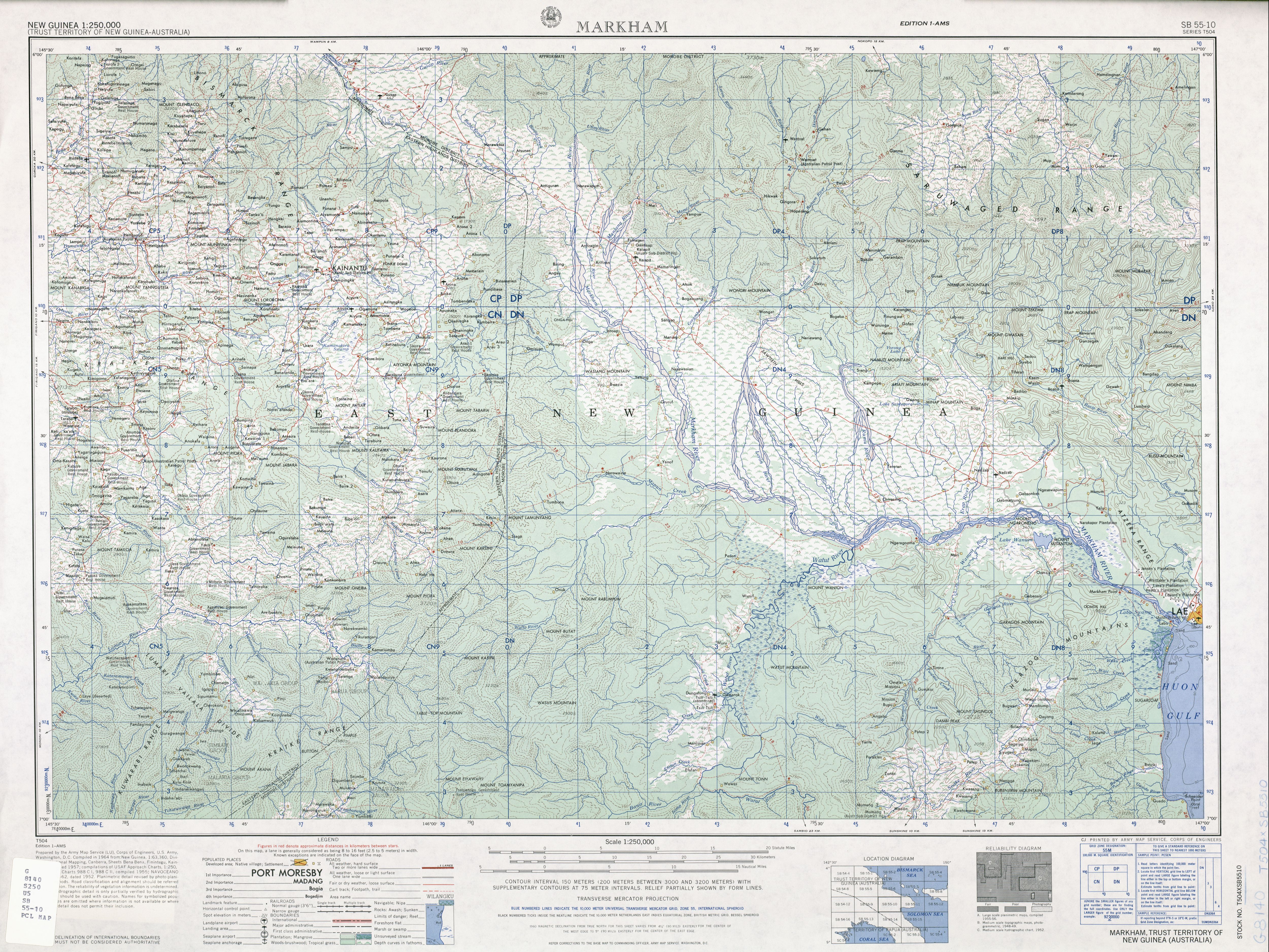
- ^ SB 55-10 Markham (5.4 MB). "Series T504, U.S. Army Map Service". Home > Finding Information > PCL Map Collection > New Guinea AMS Topographic Maps. University of Texas at Austin. Retrieved 4 March 2014.
{{cite web}}: CS1 maint: numeric names: authors list (link) - ^ a b "Nadzab airborne operation". Official Website of the 503d Parachute RCT Association of WWII. Retrieved 28 February 2014.
- ^ a b Malum Nalu (April 24, 2009). "Nadzab Airport". Retrieved 4 March 2014.
- ^ Allied Geographical Section-Southwest Pacific Area-Terrain Handbook 4 (No.738). Lae and the Lower Markham Valley28 July "Archived copy" (PDF). Archived from the original (PDF) on 2014-02-03. Retrieved 2014-01-30.
{{cite web}}: CS1 maint: archived copy as title (link) accessed 30 January 2014 - ^
 This article incorporates public domain material from the Air Force Historical Research Agency
- ^ Maurer, Maurer (1983). Air Force Combat Units Of World War II. Maxwell AFB, Alabama: Office of Air Force History. ISBN 0-89201-092-4.
- ^ www.pacificwrecks.com
- ^ a b The old Lae airport, Dec 03, 2007, Malum Nalu accessed 8 Jan 2014
- ^ "P2-006 Accident description". Aviation Safety Network. Retrieved 27 July 2010.
External links
Previously: Philippine Department Air Force (1941); Far East Air Force (1941-1942) | |||||||||||||||||||||||||||||
| Airfields |
|  | |||||||||||||||||||||||||||
| Units |
| ||||||||||||||||||||||||||||