
Laar | |
|---|---|
Location of Laar within Grafschaft Bentheim district 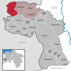 | |
 Laar  Laar | |
| Coordinates: 52°37′00″N 06°43′59″E / 52.61667°N 6.73306°E | |
| Country | Germany |
| State | Lower Saxony |
| District | Grafschaft Bentheim |
| Municipal assoc. | Emlichheim |
| Government | |
| • Mayor | Gerhard Trüün (CDU) |
| Area | |
| • Total | 51.01 km2 (19.70 sq mi) |
| Elevation | 9 m (30 ft) |
| Population (2021-12-31)[1] | |
| • Total | 2,109 |
| • Density | 41/km2 (110/sq mi) |
| Time zone | UTC+01:00 (CET) |
| • Summer (DST) | UTC+02:00 (CEST) |
| Postal codes | 49824 |
| Dialling codes | 05947 |
| Vehicle registration | NOH |
Laar (German pronunciation: [ˈlaːɐ̯]) is a community in the district of Grafschaft Bentheim in Lower Saxony. The community’s name comes from the Old Dutch for “glade in the woods”.
YouTube Encyclopedic
-
1/3Views:119 96910 633529
-
Laár András: Buddhizmus a mindennapi életben
-
Breng Arnhem: Trolleylijn 2 Hoogkamp - De Laar West Trajectvideo
-
Agterhorn & Laar Grafschaft Bentheim 2662013 MS
Transcription
Geography
Location
Laar lies northwest of Nordhorn on the German-Dutch border. It belongs to the Joint Community (Samtgemeinde) of Emlichheim, whose administrative seat is in the like-named town. The Vechte runs through the community.
Neighbouring communities
The community of Laar borders in the south on the communities of Wielen and Wilsum, in the east on the community of Emlichheim, in the north on the Dutch community of Coevorden and in the west on the Dutch community of Hardenberg in Overijssel.
Constituent communities
The community of Laar consists of the six constituent centres (Ortsteile) of Agterhorn, Echteler, Eschebrügge, Heesterkante, Laar and Vorwald.
Religion
Although Laar is a small village, it nonetheless has three church parishes: Evangelical-Reformed, Catholic and Evangelical-Old Reformed.
Politics
Municipal council
Laar’s council is made up of 13 councillors.
(as of municipal election on 10 September 2006)
Mayor
The honorary mayor Jan Hindrik Zwaferink was elected at the municipal council’s constitutive meeting.
References
External links
- Official website
 (in German)
Towns and municipalities in Grafschaft Bentheim (district) | ||
|---|---|---|
 | ||
| International | |
|---|---|
| National | |