
La Pêche | |
|---|---|
 | |
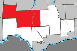 Location within Les Collines-de-l'Outaouais RCM | |
 La Pêche Location in western Quebec | |
| Coordinates: 45°41′N 75°59′W / 45.683°N 75.983°W[1] | |
| Country | Canada |
| Province | Quebec |
| Region | Outaouais |
| RCM | Les Collines-de-l'Outaouais |
| Constituted | January 1, 1975 |
| Government | |
| • Mayor | Guillaume Lamoureux |
| • Federal riding | Pontiac |
| • Prov. riding | Gatineau |
| Area | |
| • Total | 616.50 km2 (238.03 sq mi) |
| • Land | 577.18 km2 (222.85 sq mi) |
| Population (2021)[3] | |
| • Total | 8,636 |
| • Density | 15/km2 (40/sq mi) |
| • Pop 2016-2021 | |
| • Dwellings | 4,962 |
| Time zone | UTC−05:00 (EST) |
| • Summer (DST) | UTC−04:00 (EDT) |
| Postal code(s) | |
| Area code | 819 |
| Highways | |
| Website | www |
La Pêche (Standard Quebec French: [la pɛːʃ], colloquially [la paɪ̯ʃ]; "The Peach") is a municipality along both sides of the Gatineau River in Les Collines-de-l'Outaouais Regional County Municipality in the Outaouais region of Quebec, Canada, about 30 km (19 mi) north of downtown Gatineau.
Bordering on the north side of the Gatineau Park, La Pêche provides multiple access points to this park.
La Pêche was declared Quebec's first and Canada's second fair trade town on November 9, 2007.
YouTube Encyclopedic
-
1/5Views:14 984 347155 0162 875 84424 475278 437
-
Ce MONSTRE m'à TIRÉ SOUS L'EAU (Pêche à la ligne à main) - Cyril Chauquet
-
La pêche du requin à Madagascar | SLICE | Documentaire complet
-
LE PLUS GROS POISSON D'EAU DOUCE AU MONDE - Cyril Chauquet
-
La pêche sous glace avec les Tsaatans I SLICE
-
LA PÊCHE EN MER : Du filet à la criée - C'est Pas Sorcier
Transcription
Communities

It includes the following villages and communities:
- Duclos
- East Aldfield
- Edelweiss
- Farrellton
- Lac-des-Loups (Wolf Lake)
- Lascelles, Rupert and Alcove
- Sainte-Cécile-de-Masham
- Saint-François-de-Masham
- Saint-Louis-de-Masham
- Wakefield
History
The geographic townships of Aldfield, Masham, and Wakefield were already plotted on the Gale and Duberger Map of 1795, all named after places in Yorkshire, England. Around 1825, logging began in the area, while European settlement began around 1847 with the arrival of large number of people of York County in England.[1]
La Pêche was formed in 1975 through the merger of the township municipalities of Wakefield and Aldfield, the village of Wakefield, and the municipality of Sainte-Cécile-de-Masham. It was named after La Pêche Lake and La Pêche River.[1]
Demographics
| 2021 | 2016 | 2011 | |
|---|---|---|---|
| Population | 8,636 (+9.8% from 2016) | 7,863 (3.2% from 2011) | 7,619 (1.9% from 2006) |
| Land area | 577.18 km2 (222.85 sq mi) | 585.93 km2 (226.23 sq mi) | 584.65 km2 (225.73 sq mi) |
| Population density | 15/km2 (39/sq mi) | 13.4/km2 (35/sq mi) | 13.0/km2 (34/sq mi) |
| Median age | 46.4 (M: 45.6, F: 46.4) | 46.1 (M: 45.9, F: 46.4) | 44.5 (M: 44.0, F: 45.1) |
| Private dwellings | 4,962 (total) 3,669 (occupied) | 4,665 (total) | 4,490 (total) |
| Median household income | $87,000 | $71,936 | $67,512 |
| Year | Pop. | ±% |
|---|---|---|
| 1986 | 5,394 | — |
| 1991 | 5,854 | +8.5% |
| 1996 | 6,160 | +5.2% |
| 2001 | 6,453 | +4.8% |
| 2006 | 7,477 | +15.9% |
| 2011 | 7,619 | +1.9% |
| 2016 | 7,863 | +3.2% |
| 2021 | 8,636 | +9.8% |
Mother tongue:[9]
- English as first language: 36.8%
- French as first language: 58.0%
- English and French as first language: 1.8%
- Other as first language: 2.6%
See also
References
- ^ a b c "Banque de noms de lieux du Québec: Reference number 72446". toponymie.gouv.qc.ca (in French). Commission de toponymie du Québec.
- ^ a b "Répertoire des municipalités: Geographic code 82035". www.mamh.gouv.qc.ca (in French). Ministère des Affaires municipales et de l'Habitation.
- ^ a b "Census Profile, 2021 Census, Statistics Canada - Validation Error".
- ^ "2021 Community Profiles". 2021 Canadian Census. Statistics Canada. February 4, 2022. Retrieved 2023-10-19.
- ^ "2016 Community Profiles". 2016 Canadian Census. Statistics Canada. August 12, 2021. Retrieved 2019-12-09.
- ^ "2011 Community Profiles". 2011 Canadian Census. Statistics Canada. March 21, 2019. Retrieved 2019-12-09.
- ^ "2006 Community Profiles". 2006 Canadian Census. Statistics Canada. August 20, 2019.
- ^ "2001 Community Profiles". 2001 Canadian Census. Statistics Canada. July 18, 2021.
- ^ "La Pêche (Code 2482035) Census Profile". 2016 census. Government of Canada - Statistics Canada.
External links
Adjacent Municipal Subdivisions | ||||||||||||||||
|---|---|---|---|---|---|---|---|---|---|---|---|---|---|---|---|---|
| ||||||||||||||||
| Municipalities | |
|---|---|
| |