
Lüdder | |
|---|---|
 Coat of arms | |
Location of Lüdder within Uelzen district 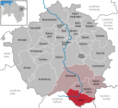 | |
 Lüdder  Lüdder | |
| Coordinates: 52°49′N 10°40′E / 52.817°N 10.667°E | |
| Country | Germany |
| State | Lower Saxony |
| District | Uelzen |
| Municipal assoc. | Aue |
| Subdivisions | 4 |
| Government | |
| • Mayor | Eberhard Siemeke (CDU) |
| Area | |
| • Total | 55.33 km2 (21.36 sq mi) |
| Elevation | 69 m (226 ft) |
| Population (2021-12-31)[1] | |
| • Total | 1,255 |
| • Density | 23/km2 (59/sq mi) |
| Time zone | UTC+01:00 (CET) |
| • Summer (DST) | UTC+02:00 (CEST) |
| Postal codes | 29394 |
| Dialling codes | 05824 |
| Vehicle registration | UE |
Lüder is a municipality in the district of Uelzen, in Lower Saxony, Germany.
Through the area flows a small river of the same name, with its source in the upland bog of the Völzberger Köpfchen[2] and its mouth where it flows into the Fulda.[3]
YouTube Encyclopedic
-
1/3Views:496 4031 8191 195
-
Wer den Wind sät… Was westliche Politik im Orient anrichtet | Michael Lüders | SWR Tele-Akademie
-
Ethno Health - Expertengespräch mit Lüder Schulz
-
Peter Lüder - Speaker
Transcription
References
- ^ "LSN-Online Regionaldatenbank, Tabelle A100001G: Fortschreibung des Bevölkerungsstandes, Stand 31. Dezember 2021" (in German). Landesamt für Statistik Niedersachsen.
- ^ "Lüderquelle (Rechte Lüder)". Google Maps. Google, Inc. Retrieved 8 May 2022.
- ^ "Lüdermündung 36041 Fulda, Germany". Google Maps. Google, Inc. Retrieved 8 May 2022.
Towns and municipalities in Uelzen (district) | ||
|---|---|---|
| International | |
|---|---|
| National | |
This Uelzen (district) location article is a stub. You can help Wikipedia by expanding it. |