
Kumru | |
|---|---|
District and municipality | |
 Map showing Kumru District in Ordu Province | |
 Kumru Location in Turkey | |
| Coordinates: 40°52′28″N 37°15′50″E / 40.87444°N 37.26389°E | |
| Country | Turkey |
| Province | Ordu |
| Government | |
| • Mayor | Yusuf Yalçuva (AKP) |
| Area | 296 km2 (114 sq mi) |
| Elevation | 470 m (1,540 ft) |
| Population (2022)[1] | 28,436 |
| • Density | 96/km2 (250/sq mi) |
| Time zone | TRT (UTC+3) |
| Postal code | 52800 |
| Area code | 0452 |
| Climate | Cfb |
| Website | www |
Kumru is a municipality and district of Ordu Province, Turkey.[2] Its area is 296 km2,[3] and its population is 28,436 (2022).[1] The town lies at an elevation of 470 m (1,542 ft).
YouTube Encyclopedic
-
1/1Views:2 775
-
Köylü Kızı Semra - Ordu / Kumru
Transcription
Geography
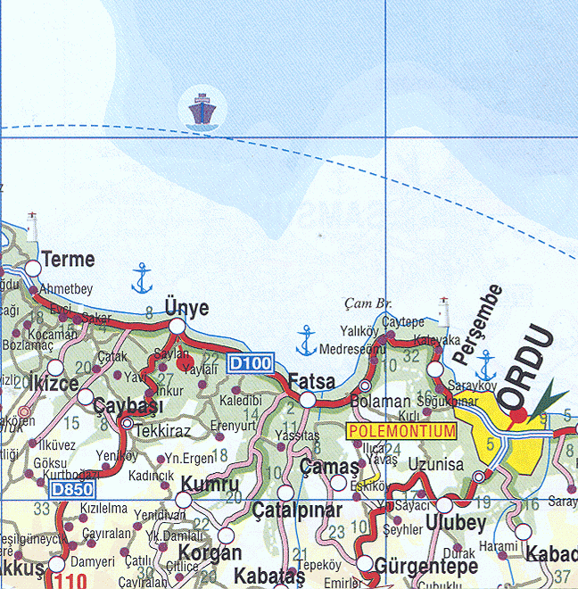
Kumru is a small, remote town sandwiched between two mountains, 33 km inland from the Black Sea coast. Kumru is located approximately thirty-five kilometers southwest of Fatsa. The distance to Ordu is seventy kilometers. It borders four cities and towns: Korgan, Akkuş, Fatsa, Ünye, and Niksar. Ortaca which is locally known as Gebekse is a village of Kumru. Ortaçokdeğirmen which got its name from the mills built on the rivers is another village of Kumru. It is located on the sides of Canik mountains and about 15 minutes to Ericek plateau where mountain strawberry is naturally grown.
Composition
There are 40 neighbourhoods in Kumru District:[4]
- Ağcaalantürk
- Akçadere
- Avdullu
- Ayvalı
- Balı
- Ballık
- Çatılı
- Demircili
- Derbent
- Dereköy
- Divantürk
- Duman
- Ergentürk
- Erikçeli
- Esence
- Eskiçokdeğirmen
- Fatih
- Fizme
- Gökçeli
- Güneycik
- Kadıncık
- Karaağaç
- Karacalar
- Karacalı
- Kayabaşı
- Konaklı
- Kovancılı
- Küçükakçakese
- Kurtuluş
- Ortaca
- Ortaçokdeğirmen
- Samur
- Şenyurt
- Tekkeköy
- Yalnızdam
- Yemişken
- Yeniakçaalan
- Yenidivan
- Yeniergen
- Yukarıdamlalı
References
- ^ a b "Address-based population registration system (ADNKS) results dated 31 December 2022, Favorite Reports" (XLS). TÜİK. Retrieved 19 September 2023.
- ^ Büyükşehir İlçe Belediyesi, Turkey Civil Administration Departments Inventory. Retrieved 19 September 2023.
- ^ "İl ve İlçe Yüz ölçümleri". General Directorate of Mapping. Retrieved 19 September 2023.
- ^ Mahalle, Turkey Civil Administration Departments Inventory. Retrieved 19 September 2023.
External links
- District municipality's official website (in Turkish)
- Kumru State Hospital (in Turkish)
- Road map of Kumru and environs
- Various images of Kumru, Ordu
- Kumru news portal (in Turkish)
- Kumru news website (in Turkish)
Kumru, Ordu in Ordu Province of Turkey | |||||||||||||||||||||||||||
|---|---|---|---|---|---|---|---|---|---|---|---|---|---|---|---|---|---|---|---|---|---|---|---|---|---|---|---|
| Districts |  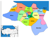 | ||||||||||||||||||||||||||
|
Metropolitan municipalities are bolded. | |||||||||||||||||||||||||||
This article about a Black Sea Region of Turkey location is a stub. You can help Wikipedia by expanding it. |