
| Krassó-Szörény County | |
|---|---|
| County of the Kingdom of Hungary | |
| 1881–1920 | |
 Coat of arms
| |
 | |
| Capital | Lugos |
| Area | |
| • Coordinates | 45°41′N 21°54′E / 45.683°N 21.900°E |
• 1910 | 11,074 km2 (4,276 sq mi) |
| Population | |
• 1910 | 466,147 |
| History | |
• Established | 1881 |
• Treaty of Trianon | 4 June 1920 |
| Today part of | Romania Serbia |
| Lugoj is the current name of the capital | |
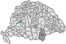
Krassó-Szörény (Hungarian: Krassó-Szörény, Romanian: Caraș-Severin, Serbian: Karaš-Severin or Караш-Северин) was an administrative county (comitatus) of the historic Kingdom of Hungary.[1] Its territory is now mostly located in south-western Romania, with one very small part which is located in Serbia. The capital of the county was Lugos (present-day Lugoj).
Geography

Krassó-Szörény County was located in the Banat region. It shared borders with the Kingdom of Serbia and the Hungarian counties of Temes, Arad and Hunyad. The river Danube formed its southern border, and the river Mureș its northern border. The rivers Bega, Timiș, Bârzava, Caraș, Nera and Cerna flowed through the county. Its area was 11,032 km2 (4,259 sq mi) around 1910.
History
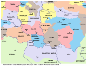
Krassó-Szörény county was formed in 1881 by uniting the counties of Krassó (its center was Lugos/Lugoj) and Szörény (its center was Karánsebes/Caransebeș). Previously, Krassó County had been re-established in 1779, with significantly different borders than in medieval times, while Szörény County had only been established in 1873 (it was the shortest-lived county in the modern Kingdom of Hungary), mostly on the territory of the former Vlach Regiment of the Banat Military Frontier.
In 1920, by the Treaty of Trianon, most of the county was assigned to Romania, with one small part (villages of Banatska Subotica and Dobričevo) which was assigned to the Kingdom of Serbs, Croats and Slovenes. The north of the county (including Lugoj) is now part of the Romanian county of Timiș, except for a 10 km (6.2 mi) wide strip along the Mureș River, which is in Arad County. The rest now forms Caraș-Severin County, except for the city Orșova, which is in Mehedinți County.
Demographics

| Census | Total | Romanian | German | Hungarian | Serbian | Slovak | Croatian | Other or unknown |
|---|---|---|---|---|---|---|---|---|
| 1880[2] | 381,304 | 289,849 (78.35%) | 37,833 (10.23%) | 7,201 (1.95%) | 18,686 (5.05%)[b] | 6,247 (1.69%) | – | 10,117 (2.73%) |
| 1890[3] | 407,635 | 311,335 (76.38%) | 48,058 (11.79%) | 10,879 (2.67%) | 11,862 (2.91%) | 5,723 (1.40%) | 5,018 (1.23%) | 14,760 (3.62%) |
| 1900[4] | 443,001 | 328,371 (74.12%) | 55,256 (12.47%) | 21,439 (4.84%) | 13,138 (2.97%) | 3,831 (0.86%) | 279 (0.06%) | 20,687 (4.67%) |
| 1910[5] | 466,147 | 336,082 (72.10%) | 55,883 (11.99%) | 33,787 (7.25%) | 14,674 (3.15%) | 2,908 (0.62%) | 319 (0.07%) | 22,494 (4.83%) |
| Census | Total | Eastern Orthodox | Roman Catholic | Greek Catholic | Calvinist | Jewish | Other or unknown |
|---|---|---|---|---|---|---|---|
| 1880 | 381,304 | 295,820 (77.58%) | 62,080 (16.28%) | 16,590 (4.35%) | 1,619 (0.42%) | 3,243 (0.85%) | 1,952 (0.51%) |
| 1890 | 407,635 | 306,023 (75.07%) | 73,817 (18.11%) | 18,949 (4.65%) | 3,053 (0.75%) | 3,713 (0.91%) | 2,080 (0.51%) |
| 1900 | 443,001 | 325,613 (73.50%) | 84,748 (19.13%) | 18,262 (4.12%) | 7,792 (1.76%) | 4,375 (0.99%) | 2,211 (0.50%) |
| 1910 | 466,147 | 337,153 (72.33%) | 90,479 (19.41%) | 20,006 (4.29%) | 10,400 (2.23%) | 4,795 (1.03%) | 3,314 (0.71%) |
Subdivisions

In the early 20th century, the subdivisions of Krassó-Szörény county were:
| Districts (járás) | |
|---|---|
| District | Capital |
| Béga | Bálinc (now Balinț) |
| Boksanbánya | Boksanbánya (now Bocșa Montană) |
| Bozovics | Bozovics (now Bozovici) |
| Facsád | Facsád (now Făget) |
| Jám | Jám (now Iam) |
| Karánsebes | Karánsebes (now Caransebeș) |
| Lugos | Lugos (now Lugoj) |
| Maros | Marosberkes (now Birchiș) |
| Oravicabánya | Oravicabánya (now Oravița) |
| Orsova | Orsova (now Orșova) |
| Resicabánya | Resicabánya (now Reșița) |
| Temes | Szákul (now Sacu) |
| Teregova | Teregova (now Teregova) |
| Újmoldova | Újmoldova (now Moldova Nouă) |
| Urban districts (rendezett tanácsú város) | |
| Karánsebes (now Caransebeș) | |
| Lugos (now Lugoj) | |
Notes
References
- ^ Zoltán Gál, The banking functions of the Hungarian urban network in the early 20th century, Centre for Regional Studies, 2006, table 6 [1]
- ^ "Az 1881. év elején végrehajtott népszámlálás főbb eredményei megyék és községek szerint rendezve, II. kötet (1882)". library.hungaricana.hu. Retrieved 28 September 2021.
- ^ "A Magyar Korona országainak helységnévtára (1892)". library.hungaricana.hu. Retrieved 29 September 2021.
- ^ "A MAGYAR KORONA ORSZÁGAINAK 1900". library.hungaricana.hu. Retrieved 29 September 2021.
- ^ "KlimoTheca :: Könyvtár". Kt.lib.pte.hu. Retrieved 29 September 2021.
