
Kornelimünster/Walheim | |
|---|---|
Location of Kornelimünster/Walheim  | |
 Kornelimünster/Walheim  Kornelimünster/Walheim | |
| Coordinates: 50°43′17″N 6°10′49″E / 50.72139°N 6.18028°E | |
| Country | Germany |
| State | North Rhine-Westphalia |
| District | Urban district |
| City | Aachen |
| Area | |
| • Total | 37.03 km2 (14.30 sq mi) |
| Elevation | 240 m (790 ft) |
| Population (2020-12-31)[1] | |
| • Total | 15,289 |
| • Density | 410/km2 (1,100/sq mi) |
| Time zone | UTC+01:00 (CET) |
| • Summer (DST) | UTC+02:00 (CEST) |
| Postal codes | 52076 |

Kornelimünster/Walheim is the southernmost Stadtbezirk (borough) of Aachen, Germany, and borders the Eifel area of North Rhine-Westphalia, as well as Belgium. It became part of Aachen in 1972, after all of the communities surrounding the city were reorganized administratively.[2] The countryside is called Münsterländchen.
YouTube Encyclopedic
-
1/3Views:1 4401 3701 635
-
Driving through Aachen (Germany) from Walheim to Drielandenpunt 20.03.2016 Timelapse x4
-
Driving through Aachen (Germany) from Zentrum to Walheim 20.03.2016 Timelapse x4
-
Vennbahnradweg_Querung Himmelsleiter2
Transcription
Communities


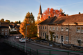
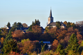
- Kornelimünster, Administrative seat of the district, with historic town center
- Walheim, central business area of the district, and its largest community
- Friesenrath, on the border with the Eifel community of Roetgen
- Hahn, on the Inde River
- Lichtenbusch, German-Belgian border town with a border crossing for A44/E40
- Nütheim
- Oberforstbach, including an industrial park on Pascalstraße (especially for businesses specializing in information technology)
- Schleckheim
- Schmithof on the Vennbahn
- Sief, with border crossing to Raeren (Belgium)
- Eich
Pictures
-
 Chapel in Kornelimünster
 -
 Kornelimünster, street view Napoleonsberg
 -
 Streetview of Friesenrath
 -
 Streetview of Schleckheim
 -
 Streetview of Eich
 -
 Streetview of Hahn
 -
 Streetview of Lichtenbusch
 -
 Streetview of Nütheim
 -
 Streetview of Oberforstbach
 -
 Streetview of Sief
 -
 View of Schmithof
 -
 Walheim church


Landmarks/Attractions

- Kornelimünster's historic city center, with timber-framed structures on the Inde River
- former Kornelimünster Abbey, now the site of the Art of NRW, which is open to the public
- Kornelimünster Abbey gardens
- Provost Kornelimünster Church (originally from 814 to 817 AD)
- Varnenum - Excavations at Kornelimünster of a Gallo-Roman temple system
- former quarry and lime kiln in Walheim and Hahn (with posted information boards)
- Former quarry in Walheim now a large public space with playgrounds, minigolf, barbecue facilities and access to the Vennbahn path
- Historic landmark, St. Stephanus Church and cemetery
- Historic landmark, Maria in the Snow Chapel
- St. Anthony-Chapel, a small church that was destroyed in an earthquake and rebuilt in the 18th century
- Iter and Inde valley
Events

- Historical fairground (Kornelimünster)
- Thanksgiving (Walheim)
- Carnival (Lichtenbusch/Oberforstbach)
- Open air carnival (Kornelimünster)
- Festival of stars (Schleckheim)
Twin towns and sister cities

- Montebourg (France), a sister city of Walheim since 1960, which was carried over to the district after Kornelimünster and Walheim were merged in 1972. Montebourg is a commune in the Manche department (Basse-Normandie) in Normandy in north-western France. It is located southeast of Cherbourg.
References
- ^ "Einwohnerstatistik (xlsx) 31.12.2020". Open Data Portal Aachen. Retrieved 24 September 2021.
- ^ Bünermann, Martin; Köstering, Heinz (1975). Communities and Districts After the Area Community Reform in North Rhine-Westphalia (Die Gemeinden und Kreise nach der kommunalen Gebietsreform in Nordrhein-Westfalen). Köln: German Publishing Community (Deutscher Gemeindeverlag). ISBN 3-555-30092-X.
External links
Districts of Aachen | ||
|---|---|---|