
| Kola | |
|---|---|
 | |
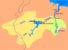 Kola-Tuloma river basins. Kola basin in green | |
| Location | |
| Country | Russia |
| Physical characteristics | |
| Source | |
| • location | Lake Kolozero |
| • elevation | 140 m (460 ft) |
| Mouth | |
• location | Kola Bay |
• coordinates | 68°53′12″N 33°02′07″E / 68.8868°N 33.0353°E |
| Length | 83 km (52 mi) |
| Basin size | 3,850 km2 (1,490 sq mi) |
| Discharge | |
| • average | 40 m3/s (1,400 cu ft/s) |
The Kola (Russian: Кола) is a river on the Kola Peninsula in Murmansk Oblast, Russia. It is 83 kilometres (52 mi) long, and has a drainage basin of 3,850 square kilometres (1,490 sq mi).[1] The river flows out of Lake Kolozero north into the Kola Bay of the Barents Sea, some 10 km south of Murmansk. The neighbouring river Tuloma has its mouth just one kilometer to the west. The average discharge is 40 m3/s, but there are large seasonal variations. Its largest tributaries is Kitza and Orlovka from the right, and Tukhta and Medvezhya from the left. The only town on the river is also called Kola.
References
- ^ "Река КОЛА in the State Water Register of Russia". textual.ru (in Russian).
| International | |
|---|---|
| National | |
| Other | |
This Murmansk Oblast location article is a stub. You can help Wikipedia by expanding it. |
This article related to a river in Russia is a stub. You can help Wikipedia by expanding it. |