Klahr, Pennsylvania | |
|---|---|
| Coordinates: 40°17′52″N 78°30′45″W / 40.29778°N 78.51250°W | |
| Country | United States |
| State | Pennsylvania |
| County | Blair |
| Township | Greenfield |
| Area | |
| • Total | 0.14 sq mi (0.35 km2) |
| • Land | 0.14 sq mi (0.35 km2) |
| • Water | 0.00 sq mi (0.00 km2) |
| Elevation | 1,625 ft (495 m) |
| Population | |
| • Total | 76 |
| • Density | 562.96/sq mi (217.00/km2) |
| Time zone | UTC-5 (Eastern (EST)) |
| • Summer (DST) | UTC-4 (EDT) |
| ZIP Code | 16625 (Claysburg) |
| Area code(s) | 814/582 |
| FIPS code | 42-40072 |
| GNIS feature ID | 2805516[3] |
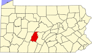
Klahr is an unincorporated community and census-designated place (CDP) in Blair County, Pennsylvania, United States. It was first listed as a CDP prior to the 2020 census.[3]
The CDP is in southwestern Blair County, in the southern part of Greenfield Township. It sits at the head of the valley of Smoky Run, at the base of Spruce Knob, an eastern spur of Blue Knob, the second-highest summit in Pennsylvania. Smoky Run is a southeastward-flowing tributary of Beaverdam Creek, one of the main headwater tributaries of the Frankstown Branch of the Juniata River, part of the Susquehanna River watershed.
Locust Hollow Road is the main street through Klahr, leading north 2 miles (3 km) to Ski Gap and southeast 2.5 miles (4.0 km) to Cotton Town. Claysburg is 5 miles (8 km) by road to the east, and Hollidaysburg is 20 miles (32 km) to the northeast.
YouTube Encyclopedic
-
1/2Views:4 428587
-
Ft. Leavenworth: John Boyd and Air Power Theory
-
Board of Directors Meeting
Transcription
Demographics
| Census | Pop. | Note | %± |
|---|---|---|---|
| 2020 | 76 | — | |
| U.S. Decennial Census[4] | |||
References
- ^ "ArcGIS REST Services Directory". United States Census Bureau. Retrieved October 12, 2022.
- ^ "Census Population API". United States Census Bureau. Retrieved October 12, 2022.
- ^ a b "Klahr Census Designated Place". Geographic Names Information System. United States Geological Survey, United States Department of the Interior.
- ^ "Census of Population and Housing". Census.gov. Retrieved June 4, 2016.


