
Khuan Kalong
ควนกาหลง | |
|---|---|
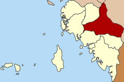 District location in Satun province | |
| Coordinates: 6°50′48″N 100°4′18″E / 6.84667°N 100.07167°E | |
| Country | Thailand |
| Province | Satun |
| Seat | Khuan Kalong |
| Area | |
| • Total | 412.9 km2 (159.4 sq mi) |
| Population (2005) | |
| • Total | 29,538 |
| • Density | 71.5/km2 (185/sq mi) |
| Time zone | UTC+7 (ICT) |
| Postal code | 91130 |
| Geocode | 9103 |
Khuan Kalong (Thai: ควนกาหลง, pronounced [kʰūa̯n kāː.lǒŋ]) is a district (amphoe) of Satun province, southern Thailand.
History
The minor district (king amphoe) Khuan Kalong was established on 1 June 1969 by splitting the three tambons Thung Nui, Pae-ra, and Tha Phae from Mueang Satun district.[1] It was upgraded to a full district on 8 September 1976.[2] On 1 June 1976 the two southwestern tambons of the district were split off to form Tha Phae Minor district. In 1996 the northwestern part was split off to form Manang district
Geography
Neighboring districts are (from the north clockwise) Palian of Trang province; Pa Bon of Phatthalung province; Rattaphum, Hat Yai, Khlong Hoi Khong and Sadao of Songkhla province; and Khuan Don, Tha Phae, La-ngu and Manang of Satun Province.
Administration
The district is divided into three sub-districts (tambons), which are further subdivided into 31 villages (muban). There are no municipal (thesaban) areas, and three tambon administrative organizations (TAO).
| No. | Name | Thai name | Villages | Pop. |
|---|---|---|---|---|
| 1. | Thung Nui | ทุ่งนุ้ย | 12 | 9,720 |
| 2. | Khuan Kalong | ควนกาหลง | 11 | 12,412 |
| 3. | Udai Charoen | อุใดเจริญ | 8 | 7,406 |
References
- ^ ประกาศกระทรวงมหาดไทย เรื่อง แบ่งท้องที่ตั้งเป็นกิ่งอำเภอ (PDF). Royal Gazette (in Thai). 86 (49 ง): 1864. June 3, 1969. Archived from the original (PDF) on March 24, 2012.
- ^ พระราชกฤษฎีกาตั้งอำเภอเลาขวัญ อำเภอคำม่วง อำเภอพิปูน อำเภอศรีเทพ อำเภอนาแห้ว อำเภอส่องดาว อำเภอควนกาหลง อำเภอค่ายบางระจัน อำเภอบ้านตาขุน และอำเภอกุดจับ พ.ศ. ๒๕๑๙ (PDF). Royal Gazette (in Thai). 93 (109 ก special): 31–34. September 8, 1976. Archived from the original (PDF) on September 27, 2007.
External links
This Satun Province location article is a stub. You can help Wikipedia by expanding it. |