
Khorramabad County
Persian: شهرستان خرمآباد | |
|---|---|
County | |
 | |
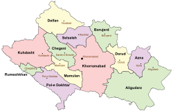 Location of Khorramabad County in Lorestan province (center, pink) | |
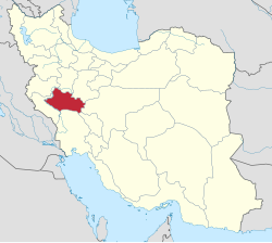 Location of Lorestan province in Iran | |
| Coordinates: 33°21′N 48°31′E / 33.350°N 48.517°E[1] | |
| Country | |
| Province | Lorestan |
| Capital | Khorramabad |
| Districts | Central, Beyranvand, Papi, Zagheh |
| Population (2016)[2] | |
| • Total | 506,471 |
| Time zone | UTC+3:30 (IRST) |
| Khorramabad County can be found at GEOnet Names Server, at this link, by opening the Advanced Search box, entering "9207199" in the "Unique Feature Id" form, and clicking on "Search Database". | |
Khorramabad County (Persian: شهرستان خرمآباد) is in Lorestan province, Iran. Its capital is the city of Khorramabad.[3]
At the 2006 census, the county's population was 509,251 in 113,886 households.[4] The following census in 2011 counted 487,167 people in 128,600 households,[5] by which time Dowreh-e Chegeni and Veysian Districts had been separated from the county to form Dowreh County.[6] At the 2016 census, the county's population was 506,471 in 144,958 households.[2]
YouTube Encyclopedic
-
1/3Views:2 266519391
-
Iran KhorramAbad, Chalan-Chulan historical bridge پل تاريخي چالان چولان خرم آباد ايران
-
What is Khorramabad? Explain Khorramabad, Define Khorramabad, Meaning of Khorramabad
-
آبشار بیشه در لرستان جان و گشتی کوتاه در خرم آباد زیبا
Transcription
Administrative divisions
The population history and structural changes of Khorramabad County's administrative divisions over three consecutive censuses are shown in the following table. The latest census shows four districts, 17 rural districts, and four cities.[2]
| Administrative Divisions | 2006[4] | 2011[5] | 2016[2] |
|---|---|---|---|
| Central District | 417,556 | 445,627 | 463,599 |
| Azna RD | 6,214 | 6,190 | 5,859 |
| Dehpir-e Jonubi RD | 7,479 | 9,659 | 10,258 |
| Dehpir-e Shomali RD | 6,332 | 6,108 | 6,082 |
| Kakasharaf RD | 4,091 | 3,627 | 2,742 |
| Koregah-e Gharbi RD | 45,409 | 50,971 | 42,884 |
| Koregah-e Sharqi RD | 11,294 | 12,456 | 11,759 |
| Robat RD | 8,193 | 8,400 | 10,599 |
| Khorramabad (city) | 328,544 | 348,216 | 373,416 |
| Beyranvand District1 | 11,378 | 10,879 | 12,003 |
| Beyranvand-e Jonubi RD | 6,309 | 5,994 | 6,547 |
| Beyranvand-e Shomali RD | 3,525 | 3,476 | 3,736 |
| Beyranshahr (city)2 | 1,544 | 1,409 | 1,720 |
| Dowreh-e Chegeni District3 | 31,117 | ||
| Dowreh RD | 9,208 | ||
| Kashkan RD | 10,294 | ||
| Teshkan RD | 10,303 | ||
| Sarab-e Dowreh (city) | 1,312 | ||
| Papi District | 16,898 | 13,514 | 12,204 |
| Chamsangar RD | 2,520 | 1,942 | 1,675 |
| Gerit RD | 2,145 | 1,876 | 1,539 |
| Keshvar RD | 1,873 | 1,379 | 1,206 |
| Sepiddasht RD | 5,117 | 3,741 | 3,610 |
| Tang-e Haft RD | 2,046 | 2,031 | 1,257 |
| Sepiddasht (city) | 3,197 | 2,545 | 2,917 |
| Veysian District3 | 13,029 | ||
| Shurab RD | 5,081 | ||
| Veysian RD | 6,131 | ||
| Veysian (city)4 | 1,817 | ||
| Zagheh District | 19,273 | 16,869 | 17,440 |
| Qaedrahmat RD | 7,381 | 6,449 | 6,108 |
| Razan RD | 3,102 | 2,052 | 3,260 |
| Zagheh RD | 5,951 | 5,683 | 5,296 |
| Zagheh (city) | 2,839 | 2,685 | 2,776 |
| Total | 509,251 | 487,167 | 506,471 |
| RD: Rural District 1Formerly Chaghalvandi District[7] 2Formerly Chaghalvandi[7] 3Became a part of Dowreh County[6] 4Formerly Mahmudvand[6] | |||
Wikimedia Commons has media related to Khorramabad County.
References
- ^ OpenStreetMap contributors (25 August 2023). "Khorramabad County" (Map). OpenStreetMap. Retrieved 25 August 2023.
- ^ a b c d "Census of the Islamic Republic of Iran, 1395 (2016)". AMAR (in Persian). The Statistical Center of Iran. p. 15. Archived from the original (Excel) on 12 October 2020. Retrieved 19 December 2022.
- ^ "Approval of the organization and chain of citizenship of the elements and units of the country divisions of Lorestan province, centered in the city of Khorramabad". Lamtakam (in Persian). Ministry of Interior, Political and Defense Commission of the Government Board. 21 June 1369. Archived from the original on 19 January 2024. Retrieved 19 January 2024.
- ^ a b "Census of the Islamic Republic of Iran, 1385 (2006)". AMAR (in Persian). The Statistical Center of Iran. p. 15. Archived from the original (Excel) on 20 September 2011. Retrieved 25 September 2022.
- ^ a b "Census of the Islamic Republic of Iran, 1390 (2011)". Syracuse University (in Persian). The Statistical Center of Iran. p. 15. Archived from the original (Excel) on 19 January 2023. Retrieved 19 December 2022.
- ^ a b c Davodi, Parviz (29 July 1386). "Approval letter regarding the reforms of country divisions in Lorestan province". DOTIC (Laws and Regulations Portal of the Islamic Republic of Iran) (in Persian). Ministry of Interior, Cabinet of Ministers. Archived from the original on 29 September 2015. Retrieved 24 August 2023.
- ^ a b Rahimi, Mohammadreza. "Six changes in the map of country divisions of Lorestan and Sistan and Baluchestan provinces". DOLAT (in Persian). Ministry of Interior, Cabinet of Ministers. Archived from the original on 4 August 2018. Retrieved 16 April 2023.
Lorestan Province, Iran | |||||||||||||||||||||||
|---|---|---|---|---|---|---|---|---|---|---|---|---|---|---|---|---|---|---|---|---|---|---|---|
| Capital |  | ||||||||||||||||||||||
| Counties and cities |
| ||||||||||||||||||||||
| Sights |
| ||||||||||||||||||||||
| populated places | |||||||||||||||||||||||