
Khan Na Yao
คันนายาว | |
|---|---|
 Slider and swimming pool of Siam Park City | |
 Khet location in Bangkok | |
| Country | Thailand |
| Province | Bangkok |
| Seat | Khan Na Yao |
| Khwaeng | 2 |
| Khet established | 21 November 1997 |
| Area | |
| • Total | 25.980 km2 (10.031 sq mi) |
| Population (2017) | |
| • Total | 96,751[2] |
| • Density | 3,724.05/km2 (9,645.2/sq mi) |
| Time zone | UTC+7 (ICT) |
| Postal code | 10230 |
| Geocode | 1043 |
Khan Na Yao (Thai: คันนายาว, pronounced [kʰān nāː jāːw]) is one of the 50 districts (khet) of Bangkok, Thailand. It is bounded by other Bangkok districts (from north clockwise): Bang Khen, Khlong Sam Wa, Min Buri, Saphan Sung, and Bueng Kum.
History
Khan Na Yao was separated from Bueng Kum on 14 October 1997 announcement, effective 21 November 1997, together with Saphan Sung.[3]
Its name means "long paddy-field ridge", describing the geography of the district in the past; Khan Na Yao was an agricultural district. Until now, the rice fields and its ridges are long gone; they are part of the present-day Seri Thai road.
Administration
The district is divided into two sub-districts (khwaeng).
| No. | Name | Thai | Area (km2) |
Map |
|---|---|---|---|---|
1. |
Khan Na Yao | คันนายาว | 12.917 |
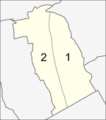
|
2. |
Ram Inthra | รามอินทรา | 13.063
| |
| Total | 25.980
| |||
Places
- Wat Rat Sattha Tham
- Navatanee Golf Course
- Siam Park City
- Fashion Island
- Bangchan Industrial Estate
District council
The District Council for Khan Na Yao has seven members, who each serve four-year terms. Elections were last held on 30 April 2006. The Thai Rak Thai Party won seven seats.
References
- ^ Administrative Strategy Division, Strategy and Evaluation Department, Bangkok Metropolitan Administration (2021). สถิติกรุงเทพมหานครประจำปี 2563 [Bangkok Statistics 2020] (PDF) (in Thai). Retrieved 27 November 2021.
{{cite web}}: CS1 maint: multiple names: authors list (link) - ^ "Population and House Report for Year 2017 (see page 2 for data of this district)". Department of Provincial Administration, Ministry of Internal Affairs. Retrieved 2018-04-01. (Search page)
- ^ ประกาศกระทรวงมหาดไทย เรื่อง เปลี่ยนแปลงพื้นที่เขตบางเขน เขตลาดพร้าว เขตบึงกุ่ม เขตประเวศ และตั้งเขตสายไหม เขตคันนายาว เขตสะพานสูง (PDF). Royal Gazette (in Thai). 114 (พิเศษ 108 ง): 6. 1997-11-18. Archived from the original (PDF) on November 7, 2011.
External links

This article related to the city of Bangkok, Thailand is a stub. You can help Wikipedia by expanding it. |