To install click the Add extension button. That's it.

The source code for the WIKI 2 extension is being checked by specialists of the Mozilla Foundation, Google, and Apple. You could also do it yourself at any point in time.

4,5
Kelly Slayton
Congratulations on this excellent venture… what a great idea!
Alexander Grigorievskiy
I use WIKI 2 every day and almost forgot how the original Wikipedia looks like.
Live Statistics
English Articles
Improved in 24 Hours
Added in 24 Hours
What we do. Every page goes through several hundred of perfecting techniques; in live mode. Quite the same Wikipedia. Just better.
.
Leo
Newton
Brights
Milds

Kawaguchi, Niigata

From Wikipedia, the free encyclopedia

Kawaguchi
川口町
Former municipality
Shinano River and Uono River
Flag of Kawaguchi
Official seal of Kawaguchi
Location of Kawaguchi in Niigata Prefecture
Location of Kawaguchi in Niigata Prefecture
CountryJapan
RegionHokuriku
PrefectureNiigata Prefecture
DistrictKitauonuma District
MergedMarch 31, 2010
(now part of Nagaoka)
Area
 • Total50.03 km2 (19.32 sq mi)
Population
 (2010)
 • Total4,801
Time zoneUTC+09:00 (JST)
Symbols
FlowerPhlox subulata
TreeCherry blossom
10 municipalities merged into Nagaoka City

Kawaguchi (川口町, Kawaguchi-machi) was a town located in Kitauonuma District, Niigata Prefecture, Japan.

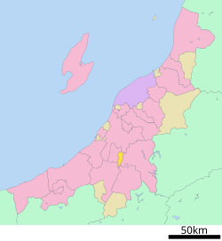
As of 2003, the town had an estimated population of 5,549 and a density of 110.91 persons per km2. The total area was 50.03 km2.

During the 2004 Chūetsu earthquake, Kawaguchi was the only town to report the maximum value of 7 on the Japan Meteorological Agency seismic intensity scale.

On March 31, 2010, Kawaguchi was merged into the expanded city of Nagaoka.[1]

YouTube Encyclopedic

  • 1/3
    Views:
    1 634
    438
    354
  • 2012 長岡市 越後 川口まつり 大花火大会 ダイジェストビデオ 1/2
  • 2012 川口まつり大花火大会 ダイジェストビデオ2/2 復興祈願花火エピセンタ
  • 7月21日 見附まつり花火大会 2012 フェニックス 見附 ダイジェストビデオ2/3

Transcription

Transportation

Railway

JR East - Jōetsu Line
JR East - Iiyama Line
  • Echigo-Kawaguchi

Highway

References

  1. ^ "Archived copy". Archived from the original on 2013-10-04. Retrieved 2010-04-02.{{cite web}}: CS1 maint: archived copy as title (link)

See also

37°16′N 138°52′E / 37.267°N 138.867°E / 37.267; 138.867


This page was last edited on 17 April 2024, at 03:39
Basis of this page is in Wikipedia. Text is available under the CC BY-SA 3.0 Unported License. Non-text media are available under their specified licenses. Wikipedia® is a registered trademark of the Wikimedia Foundation, Inc. WIKI 2 is an independent company and has no affiliation with Wikimedia Foundation.