
Kapaklı | |
|---|---|
District and municipality | |
 Map showing Kapaklı District in Tekirdağ Province | |
 Kapaklı Location in Turkey  Kapaklı Kapaklı (Marmara) | |
| Coordinates: 41°20′N 27°58′E / 41.333°N 27.967°E | |
| Country | Turkey |
| Province | Tekirdağ |
| Government | |
| • Mayor | Mustafa Çetin (AKP) |
| Area | 182 km2 (70 sq mi) |
| Elevation | 185 m (607 ft) |
| Population (2022)[1] | 137,514 |
| • Density | 760/km2 (2,000/sq mi) |
| Time zone | UTC+3 (TRT) |
| Postal code | 59510 |
| Area code | 0282 |
| Website | www |
Kapaklı (Turkish: [kaˈpakɫɯ]; Greek: Κουπέριον) is a municipality and district of Tekirdağ Province, Turkey.[2] Its area is 182 km2,[3] and its population is 137,514 (2022).[1] The district and municipality Kapaklı was created at the 2013 Turkish local government reorganisation from part of the district of Çerkezköy, including the former municipalities Kapaklı and Karaağaç.[4][5]
It is situated in the plains of Eastern Thrace. The distance to Çerkezköy is merely 7 kilometres (4.3 mi) and to Tekirdağ is 60 kilometres (37 mi). The town is quite populated because of its vicinity to industrial sites and Istanbul.
YouTube Encyclopedic
-
1/2Views:2 88214 673
-
GÜLŞEN KONSERİ - TEKİRDAĞ KAPAKLI
-
Yalova-Kapaklı köyü
Transcription
Composition
There are 21 neighbourhoods in Kapaklı District:[6]
- 19 Mayıs
- Adnan Menderes
- Atatürk
- Bahçeağıl
- Bahçelievler
- Cumhuriyet
- Fatih
- İnönü
- İsmetpaşa
- Karaağaç
- Karlı
- Kazım Karabekir
- Mevlana
- Mimar Sinan
- Ömer Halisdemir
- Pınarca
- Uzunhacı
- Vatan
- Yanıkağıl
- Yıldızkent
- Yunus Emre
References
- ^ a b "Address-based population registration system (ADNKS) results dated 31 December 2022, Favorite Reports" (XLS). TÜİK. Retrieved 19 September 2023.
- ^ Büyükşehir İlçe Belediyesi, Turkey Civil Administration Departments Inventory. Retrieved 19 September 2023.
- ^ "İl ve İlçe Yüz ölçümleri". General Directorate of Mapping. Retrieved 19 September 2023.
- ^ "İl İdaresi ve Mülki Bölümler Şube Müdürlüğü İstatistikleri - İl ve İlçe Kuruluş Tarihleri" (PDF) (in Turkish). p. 78. Retrieved 28 September 2023.
- ^ "Law No. 6360". Official Gazette (in Turkish). 6 December 2012.
- ^ Mahalle, Turkey Civil Administration Departments Inventory. Retrieved 19 September 2023.
External links
Wikivoyage has a travel guide for Kapaklı.
Kapaklı in Tekirdağ Province of Turkey | |||||||||||||||||||||||||||
|---|---|---|---|---|---|---|---|---|---|---|---|---|---|---|---|---|---|---|---|---|---|---|---|---|---|---|---|
| Districts |  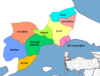 | ||||||||||||||||||||||||||
|
Metropolitan municipalities are bolded. | |||||||||||||||||||||||||||