
| Kanije Eyalet ایالت قنیژه (Ottoman Turkish) Kanizsai ejálet (Hungarian) Kaniški ejalet (Croatian) | |||||||||||
|---|---|---|---|---|---|---|---|---|---|---|---|
| Eyalet of the Ottoman Empire | |||||||||||
| 1600–1690 | |||||||||||
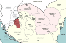 The Kanije Eyalet in 1683 | |||||||||||
| Capital | Kanije (Hungarian: Kanizsa, modern Nagykanizsa) | ||||||||||
| Area | |||||||||||
| • Coordinates | 46°27′N 16°59′E / 46.450°N 16.983°E | ||||||||||
| History | |||||||||||
• Established | 1600 | ||||||||||
• Disestablished | 1690 | ||||||||||
| |||||||||||
| Today part of | Croatia Hungary | ||||||||||

The Kanije Eyalet (Ottoman Turkish: ایالت قنیژه; Eyālet-i Ḳanije[1]) was an administrative territorial entity of the Ottoman Empire formed in 1600 and existing until the 1699 Treaty of Karlowitz. It included parts of present-day Hungary and Croatia
YouTube Encyclopedic
-
1/1Views:636
-
The Ottoman War Fought In Nagykanizsa
Transcription
History
The province of Kanije was established in 1600 after the town of Kanije was captured from Habsburgs. This newly conquered area was joined with territory of Zigetvar Province, which was formed in 1596 from some sanjaks of Budin Province[2] (which had been expanded as a result of the Ottoman territorial gains during the Long War)[3] and Bosnia Province.[4][5] The Kanije Eyalet existed until the capture of Kanije by Habsburg Monarchy in 1690. It was formally ceded to Habsburg Monarchy by the Treaty of Karlowitz in 1699.
Administrative divisions
In 1600, the Kanije Eyalet comprised the:[6]
|
The sanjaks of Kanije Eyalet in the 17th century:[7]
|
Later in the 17th century, it expanded to include the:[8]
|
References
- ^ "Some Provinces of the Ottoman Empire". Geonames.de. Archived from the original on 28 September 2013. Retrieved 25 February 2013.
- ^ Encyclopedia of the Ottoman Empire, p. 96, at Google Books By Gábor Ágoston, Bruce Alan Masters
- ^ Encyclopedia of the Ottoman Empire, p. 256, at Google Books By Gábor Ágoston, Bruce Alan Masters
- ^ Asmir Hasičić, Slavonija u sastavu Osmanskog carstva, Sarajevo, 2004.
- ^ "::: BOSANSKI PASALUK - beglerbegluk ili ejalet :::". www.camo.ch. Archived from the original on 2007-02-28.
- ^ Dr Dušan J. Popović, Srbi u Vojvodini, knjiga I, Novi Sad, 1990, page 201.
- ^ Narrative of travels in Europe, Asia, and Africa in the ..., Volume 1, p. 90, at Google Books By Evliya Çelebi, Joseph von Hammer-Purgstall
- ^ https://www.scribd.com/doc/24799068/Evliya-Celebi-Seyahatnamesi-nden-Secmeler-I Kanije Eyalet
- ^ Sezen, Tahir (2006). Osmanlı yer adları: (alfabetik sırayla) (in Turkish). T.C. Başbakanlık Devlet Arşivleri Genel Müdürlüğü. p. 523. ISBN 978-975-19-3945-6.