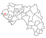
Kamsar | |
|---|---|
Sub-prefecture and city | |
| Coordinates: 10°39′N 14°37′W / 10.650°N 14.617°W | |
| Country | |
| Region | Boke Region |
| Prefecture | Boké Prefecture |
| Government | |
| • Mayor | Chérif Kibola Camara |
Kamsar is a port city in Guinea, West Africa. It is also a Sub-prefecture of Guinea. It is located on the mouth of the Nunez River.
Port Kamsar handles significant part of the world's bauxite production. Ships calling Port Kamsar and going direct to the quay of Guinea Bauxite Company for loading bauxites are limited to length overall (LOA) 229m. Ship length restrictions led to appearance of the new dry bulk carrier categories - Kamsarmax.[1]
YouTube Encyclopedic
-
1/3Views:1 4783042 487
-
Guinee Conakry_ KAMSAR VISITE I : Comment se retrouver facillement a KAMSAR
-
Africa Vlog Guinea Conakry Kamsar / beautiful place for holidays-goers.
-
Vlog:#Guinee Conakry_ Kamsar Visite II-Comment se retrouver facillement a KAMSAR
Transcription
Transport
It has a standard gauge railway line feeding bauxite from the mine at Sangarédi to the port.
The city is served by Kawass Airport.
Climate
Kamsar has a tropical monsoon climate (Am) with little to no rainfall from December to April and heavy to extremely heavy rainfall from June to October with moderate rainfall in May and November.
| Climate data for Kamsar | |||||||||||||
|---|---|---|---|---|---|---|---|---|---|---|---|---|---|
| Month | Jan | Feb | Mar | Apr | May | Jun | Jul | Aug | Sep | Oct | Nov | Dec | Year |
| Daily mean °C (°F) | 26.2 (79.1) |
26.4 (79.6) |
27.9 (82.3) |
28.7 (83.6) |
28.4 (83.2) |
26.8 (80.3) |
25.9 (78.7) |
25.7 (78.3) |
25.8 (78.5) |
26.3 (79.4) |
26.3 (79.4) |
24.9 (76.9) |
26.6 (79.9) |
| Average rainfall mm (inches) | 0 (0) |
0 (0) |
0 (0) |
6 (0.2) |
72 (2.8) |
305 (12.0) |
772 (30.4) |
999 (39.3) |
465 (18.3) |
304 (12.0) |
70 (2.8) |
5 (0.2) |
2,998 (118) |
| Source: Climate-Data.org (rainfall)[2] | |||||||||||||
Hospitals
- Hôpital ANAIM
- Centre de Santé de Kassapô
Places of Worship
- Mosquée CBG
- Église St. Jean Baptiste
- Mosquée Bagataye
- Mosquée Bas-Fond
- Mosquée Siminoune
See also
External links
References
- ^ "What Are Kamsarmax Vessels? Fully Explained And Compared". maritimepage.com. 2022-07-31. Retrieved 2022-12-03.
- ^ "Climate: Kamsar". Climate-Data.org. Retrieved August 8, 2020.


