
Kameyama
亀山市 | |
|---|---|
 Kameyama City Hall | |
 Flag  Seal | |
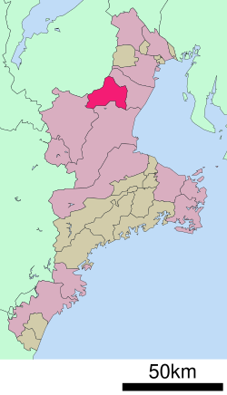 Location of Kameyama in Mie Prefecture | |
 Kameyama | |
| Coordinates: 34°51′21″N 136°27′6″E / 34.85583°N 136.45167°E | |
| Country | Japan |
| Region | Kansai |
| Prefecture | Mie |
| Government | |
| • Mayor | Yoshiyuki Sakurai (since February 2009) |
| Area | |
| • Total | 190.91 km2 (73.71 sq mi) |
| Population (August 2021) | |
| • Total | 49,457 |
| • Density | 260/km2 (670/sq mi) |
| Time zone | UTC+9 (Japan Standard Time) |
| Phone number | 0595-82-1111 |
| Address | 577 Honmaru-cho, Kameyama-shi, Mie-ken 519-0195 |
| Climate | Cfa |
| Website | Official website |
| Symbols | |
| Flower | Japanese iris |
| Tree | Cryptomeria |

Kameyama (亀山市, Kameyama-shi) is a city located in northern Mie Prefecture, Japan. As of 1 August 2021[update], the city had an estimated population of 49,457 in 21,745 households and a population density of 260 persons per km².[1] The total area of the city is 190.91 km2 (73.71 square miles).
YouTube Encyclopedic
-
1/5Views:2 4621 0273469685 348
-
関宿 Sekijuku (Kameyama, Mie, Japan )
-
Cidade de Kameyama
-
Atravessando e descendo a montanha Suzuka sentido a cidade de Kameyama - Mie
-
【Mie】亀山駅 Kameyama Station
-
How the Samurai Lived | Inside a Traditional Japanese Post Town
Transcription
Geography
Kameyama is located in the north-central part of Mie Prefecture. The Suzuka Mountains are in the northwestern part of the city, and the Nunobiki Mountains are in the southwestern part. More than half of the city's area is forest.
Neighboring municipalities
Mie Prefecture
Shiga Prefecture
Climate
Kameyama has a Humid subtropical climate (Köppen Cfa) characterized by warm summers and cool winters with light to no snowfall. The average annual temperature in Kameyama is 15.1 °C (59.2 °F). The average annual rainfall is 1,853.7 mm (72.98 in) with September as the wettest month. The temperatures are highest on average in August, at around 26.7 °C (80.1 °F), and lowest in January, at around 4.3 °C (39.7 °F).[2]
| Climate data for Kameyama (1991−2020 normals, extremes 1979−present) | |||||||||||||
|---|---|---|---|---|---|---|---|---|---|---|---|---|---|
| Month | Jan | Feb | Mar | Apr | May | Jun | Jul | Aug | Sep | Oct | Nov | Dec | Year |
| Record high °C (°F) | 16.9 (62.4) |
21.2 (70.2) |
25.6 (78.1) |
29.9 (85.8) |
32.9 (91.2) |
35.4 (95.7) |
38.3 (100.9) |
37.9 (100.2) |
35.7 (96.3) |
32.7 (90.9) |
25.9 (78.6) |
21.5 (70.7) |
38.3 (100.9) |
| Mean daily maximum °C (°F) | 8.8 (47.8) |
9.6 (49.3) |
13.5 (56.3) |
19.1 (66.4) |
23.5 (74.3) |
26.3 (79.3) |
30.2 (86.4) |
31.7 (89.1) |
27.7 (81.9) |
22.3 (72.1) |
16.8 (62.2) |
11.3 (52.3) |
20.1 (68.1) |
| Daily mean °C (°F) | 4.3 (39.7) |
4.7 (40.5) |
8.0 (46.4) |
13.2 (55.8) |
18.0 (64.4) |
21.6 (70.9) |
25.6 (78.1) |
26.7 (80.1) |
23.0 (73.4) |
17.4 (63.3) |
11.7 (53.1) |
6.6 (43.9) |
15.1 (59.1) |
| Mean daily minimum °C (°F) | 0.1 (32.2) |
0.3 (32.5) |
3.0 (37.4) |
7.9 (46.2) |
12.9 (55.2) |
17.6 (63.7) |
22.1 (71.8) |
22.9 (73.2) |
19.2 (66.6) |
13.0 (55.4) |
6.8 (44.2) |
2.2 (36.0) |
10.7 (51.2) |
| Record low °C (°F) | −5.8 (21.6) |
−6.5 (20.3) |
−4.4 (24.1) |
−1.0 (30.2) |
3.7 (38.7) |
9.6 (49.3) |
14.0 (57.2) |
14.4 (57.9) |
8.1 (46.6) |
1.9 (35.4) |
−1.7 (28.9) |
−5.4 (22.3) |
−6.5 (20.3) |
| Average precipitation mm (inches) | 57.3 (2.26) |
68.8 (2.71) |
120.0 (4.72) |
153.4 (6.04) |
203.0 (7.99) |
255.8 (10.07) |
211.2 (8.31) |
180.8 (7.12) |
284.1 (11.19) |
178.8 (7.04) |
81.3 (3.20) |
59.3 (2.33) |
1,853.7 (72.98) |
| Average precipitation days (≥ 1.0 mm) | 8.1 | 8.7 | 10.9 | 10.1 | 10.7 | 12.6 | 12.1 | 10.3 | 12.1 | 10.0 | 6.8 | 7.5 | 119.9 |
| Mean monthly sunshine hours | 145.6 | 142.9 | 176.3 | 191.1 | 196.4 | 145.1 | 163.9 | 195.1 | 149.8 | 158.1 | 154.3 | 155.3 | 1,973.7 |
| Source: Japan Meteorological Agency[3][2] | |||||||||||||
Demographics
Per Japanese census data,[4] the population of Kameyama has increased slowly over the past 50 years.
| Year | Pop. | ±% |
|---|---|---|
| 1960 | 39,148 | — |
| 1970 | 37,817 | −3.4% |
| 1980 | 40,578 | +7.3% |
| 1990 | 45,045 | +11.0% |
| 2000 | 46,606 | +3.5% |
| 2010 | 51,047 | +9.5% |
History
Kameyama developed as the castle town of Kameyama Castle, which belonged to the Ise-Kameyama Domain under the Tokugawa shogunate. In the early 17th century, the castle town was Kameyama-juku, the forty-sixth post station of Tōkaidō. Seki-juku and Sakashita-juku on the Tōkaidō, also fall within its borders. During the establishment of the modern municipalities system in the early Meiji period, Kamayama-juku was organized into the town of Kameyama within Suzuka District. It was elevated to city status on October 1, 1954.
On January 11, 2005, the town of Seki (also from Suzuka District) was merged into Kameyama.
Government
Kameyama has a mayor-council form of government with a directly elected mayor and a unicameral city council of 18 members. Kameyama contributes one member to the Mie Prefectural Assembly. In terms of national politics, the city is part of Mie 2nd district of the lower house of the Diet of Japan.
Economy
Candles are a traditional product of the city. Sharp Corporation has been operating one of the world's largest LCD factories in the city since January 8, 2004.[citation needed]
Education
Kameyama has eleven public elementary schools and three public middle schools operated by the city government and one public high school operated by the Mie Prefectural Department of Education. There is also one private high school.
Transportation
Railway
Highway
 Higashi-Meihan Expressway
- Ise Expressway
 Shin-Meishin Expressway
 National Route 1
 National Route 25
 National Route 306
Local attractions
International relations
Twin towns — Sister cities
Kameyama is twinned with:
 Gose, Nara, Japan (1998)
- Habikino, Osaka, Japan (1998)
Notable people
- Shiro Hattori - linguist
- Teinosuke Kinugasa - film director
- Kiyoshi Toyoda - baseball player
References
- ^ "Kameyama city official statistics" (in Japanese). Japan.
- ^ a b 気象庁 / 平年値(年・月ごとの値). JMA. Retrieved April 11, 2022.
- ^ 観測史上1~10位の値(年間を通じての値). JMA. Retrieved April 11, 2022.
- ^ Kameyama population statistics
External links
- Kameyama City official website (in Japanese)
| Special city | ||
|---|---|---|
| Cities | ||
| Districts | ||
| International | |
|---|---|
| National | |
| Geographic | |
| Academics | |