
Kalyvia Thorikou
Καλύβια Θορικού | |
|---|---|
 Kalyvia Thorikou Location within the regional unit 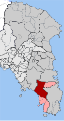 | |
| Coordinates: 37°50′N 23°55′E / 37.833°N 23.917°E | |
| Country | Greece |
| Administrative region | Attica |
| Regional unit | East Attica |
| Municipality | Saronikos |
| Area | |
| • Municipal unit | 70.636 km2 (27.273 sq mi) |
| Elevation | 110 m (360 ft) |
| Population (2021)[1] | |
| • Municipal unit | 15,486 |
| • Municipal unit density | 220/km2 (570/sq mi) |
| Time zone | UTC+2 (EET) |
| • Summer (DST) | UTC+3 (EEST) |
| Postal code | 190 10 |
| Area code(s) | 22990 |
| Vehicle registration | Z |
| Website | www.kalivia.gr |
Kalyvia Thorikou (Greek: Καλύβια Θορικού) is a town and a former municipality in East Attica, Greece. Since the 2011 local government reform it is part of the municipality Saronikos, of which it is the seat and a municipal unit.[2] The municipal unit has an area of 70.636 km2.[3] The town has historically been an Arvanite settlement.[4]
YouTube Encyclopedic
-
1/3Views:9997181 385
-
Καλύβια Θορικού Αττική
-
ΔΗΜΟΣ ΣΑΡΩΝΙΚΟΥ: ΑΓΙΟΣ ΠΕΤΡΟΣ ΣΤΑ ΚΑΛΥΒΙΑ.mpg
-
Grand Resort Lagonissi Hotel - Greece
Transcription
Geography


Kalyvia Thorikou consists of two distinct parts: the main inland town Kalyvia and the coastal settlement, which is also referred to as Lagonisi. Kalyvia proper is situated on the south side of the Mesogaia plain, in the southeastern part of the Attica peninsula. There are several low mountains around Kalyvia Thorikou, including Mount Paneion to its south and Merenta to its northeast. Kalyvia Thorikou is 7 km northeast from the Saronic Gulf coast at Lagonisi, 5 km south of Markopoulo Mesogaias, 6 km northwest of Keratea and 24 km southeast of Athens city centre. The Greek National Road 89 (Gerakas - Koropi - Lavrio - Sounio) passes east of the town.
Notable people
- Athena Manoukian, singer
Sister cities
See also
References
- ^ "Αποτελέσματα Μόνιμου Πληθυσμού κατά δημοτική κοινότητα" (in Greek). Hellenic Statistical Authority. 21 April 2023.
- ^ "ΦΕΚ B 1292/2010, Kallikratis reform municipalities" (in Greek). Government Gazette.
- ^ "Population & housing census 2001 (incl. area and average elevation)" (PDF) (in Greek). National Statistical Service of Greece. Archived from the original (PDF) on 2015-09-21.
- ^ Pantelidis, Nikos; Liosis, Nikos (2019). "Dialectical Modern Greek Influences on Arvanitika". Modern Greek Dialects and Linguistics Theory. National and Kapodistrian University of Athens: 224.
External links
- Official website (in English and Greek)
- news
Places adjacent to Kalyvia Thorikou | |
|---|---|
| International | |
|---|---|
| National | |