Kápolna | |
|---|---|
Village | |
 Immaculate Conception church | |
 Coat of arms | |
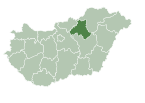
 Kápolna Location of Kápolna in Hungary | |
| Coordinates: 47°45′33″N 20°14′49″E / 47.75917°N 20.24694°E | |
| Country | |
| County | Heves |
| District | Füzesabony |
| First mentioned | 1430 |
| Government | |
| • Mayor | Kálmán Berecz, Dr. (Ind.) |
| Area | |
| • Total | 21.51 km2 (8.31 sq mi) |
| Population (2022) | |
| • Total | 1,468 |
| • Density | 68/km2 (180/sq mi) |
| Time zone | UTC+1 (CET) |
| • Summer (DST) | UTC+2 (CEST) |
| Postal code | 3355 |
| Area code | 36 |
| Website | http://kapolna.hu/ |

Kápolna is a village in Heves County, Hungary, beside of the Tarna River. As of 2022 census, it has a population of 1,468 (see Demographics). The village located beside of the (Nr. 84) Kisterenye–Kál-Kápolna railway line and on the main road 3 and 5,7 km far from the M3 motorway. Although the settlement has its own railway stop, public transport on the railway line ceased on March 3, 2007. The closest train station with public transport in Kál 3,3 km far.
YouTube Encyclopedic
-
1/3Views:2 32612 291341
-
Elhagyatott kápolna a puszta közepén!
-
The Line Kál-Kápolna - Recsk-Parádfürdő (Nr. 84 Part1)
-
Pillanatképek Ürbőpuszta múltjából - A borzasi kápolna története - Előzetes
Transcription
History
A Copper Age copper chisel was found near the village, which shows that the area was already inhabited in early historical times. The name of the village was derived from the noun chapel. The settlement was presumably given this name because at the time of its creation it did not have a church, but only a small chapel. His name appears for the first time in a royal charter issued in 1430 as Kapolna. After the extinction of the Solymosi branch of the Aba family, King Sigismund donated the village to Peter Rozgonyi, Bishop of Eger (1425-1438), who handed it over to the diocese in exchange for an estate. Kápolna remained the property of the Roman Catholic Archdiocese of Eger until 1945. The village was destroyed by the Ottomans, at time of the two siege of Eger in 1552, and 1596. At that time, the village was located east of today's village, on the part now known as Pusztatemplom beach. After the end of Ottoman rule, it was repopulated around 1694, but already between the two branches of the Tarna River. In the 18th century the village began to develop: school, post office, inn, stone bridges, horse changing station, mills, manorial sheep farm and beekeeping established. In the 1760s, Germans, Czechs, and French settled in the village. The present-day monument church was completed in 1784 and the parish in 1789. On February 26–27 in 1849 was the Battle of Kápolna that makes the village famous even today took place as an event of the Hungarian Revolution and War of Independence of 1848–1849. The memorial column erected in memory of those who fell here, it was inaugurated on December 19 in 1869 next to the then main road. This monument was also the first in the country to commemorate the Hungarian Revolution of 1848. The memory of the war is kept in the cemetery by the graves of the defenders from 1849, and the street names of the village. On the 150th anniversary of the Battle of Kápolna, the village commemorated the event that took place here with a sculpture composition erected in the then Kossuth-Dembinszky Memorial Park. The Tobacco Exchange Office was built in 1860, which began operating in 1868. In the second half of 19th century being operated regular medical care, pharmacy and kindergarten. On February 23, 1919 Mihály Károlyi the landowner and the first president of the country distributing his lands among the peasants. The land distribution memorial column placed on 80th anniversary. In the second half of the 20th century opened village library, gymnasium for the school. After 1989 the library functions as a cultural center, new doctor's office and folk museum opened.[1]
Demographics
According the 2022 census, 92.0% of the population were of Hungarian ethnicity, 18.7% were Gypsies, 2,3% were Germans and 8.0% were did not wish to answer. The religious distribution was as follows: 39.3% Roman Catholic, 1.8% Calvinist, 9.9% non-denominational, and 41.8% did not wish to answer. The Gypsies and Germans have a local nationality government. No population in farms.[2]
Population by years:[3]
| Year | 1870 | 1880 | 1890 | 1900 | 1910 | 1920 | 1930 | 1941 |
|---|---|---|---|---|---|---|---|---|
| Population | 1799 | 1860 | 1815 | 1714 | 1771 | 1837 | 1838 | 1767 |
| Year | 1949 | 1960 | 1970 | 1980 | 1990 | 2001 | 2011 | 2022 |
| Population | 1940 | 1899 | 1802 | 1630 | 1520 | 1618 | 1567 | 1468 |
Politics
Mayors since 1990:
- 1990–1998: Mátyás Lendvai (MDF, from 1994 supported by the KDNP too)[4][5]
- 1998–2002: István Molnár (independent)[6]
- 2002–2006: Mátyás Lendvai (independent)[7]
- 2006–: Kálmán Berecz, Dr. (independent)[8][9][10][11]
References
- ^ "History of Kápolna village" (in Hungarian). Retrieved 24 January 2024.
- ^ "Kápolna - Basic Data". ksh.hu. Hungarian Central Statistical Office. Retrieved 24 January 2024.
- ^ "Population number, population density". Hungarian Central Statistical Office. Retrieved 2024-02-22.
- ^ "Kápolna settlement election results" (txt) (in Hungarian). National Election Office. Retrieved 2024-01-24.
- ^ "Kápolna settlement election results" (in Hungarian). National Election Office. Retrieved 2024-01-24.
- ^ "Kápolna settlement election results" (in Hungarian). National Election Office. Retrieved 2024-01-24.
- ^ "Kápolna settlement election results" (in Hungarian). National Election Office. Retrieved 2024-01-24.
- ^ "Kápolna settlement election results" (in Hungarian). National Election Office. Retrieved 2024-01-24.
- ^ "Kápolna settlement election results" (in Hungarian). National Election Office. Retrieved 2024-01-24.
- ^ "Kápolna settlement election results" (in Hungarian). National Election Office. Retrieved 2024-01-24.
- ^ "Kápolna settlement election results" (in Hungarian). National Election Office. Retrieved 2024-01-24.
| Town (1) |
| |
|---|---|---|
| Large village (1) | ||
| Villages (14) | ||