
 Mid-latitude cyclone responsible for the storm complex on January 9, 2024 | |
| Meteorological history | |
|---|---|
| Formed | January 7, 2024 |
| Dissipated | January 12, 2024 |
| Category 1 "Notable" winter storm | |
| Regional Snowfall Index: 2.38 (NOAA) | |
| Maximum snowfall or ice accretion | 21 in (53 cm) in Wolf Creek Pass |
| Tornado outbreak | |
| Tornadoes | 35 |
| Maximum rating | EF3 tornado |
| Duration | January 8–9, 2024 |
| Highest winds | 102 mph (164 km/h) (highest convective wind) |
| Overall effects | |
| Fatalities | 6 (2 tornadic) |
| Injuries | 14+ (14+ tornadic) |
| Damage | $1.7 billion (2024 USD)[1] |
| Areas affected | Northwestern, Midwestern, and Southern United States |
Part of the tornadoes and tornado outbreaks of 2024 and 2023–24 North American winter | |
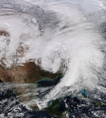
A large and robust storm system unofficially named Winter Storm Finn by The Weather Channel brought widespread impacts to much of the contiguous United States early in January 2024. In the northern United States, heavy snow, hail, and gusty winds affected areas from the Great Plains to New England. In the southern United States, a widespread tornado outbreak along the Gulf Coast caused two fatalities and numerous injuries.
YouTube Encyclopedic
-
1/2Views:1 078 03421 500
-
Is Dyatlov Pass Mystery Finally Solved
-
How 7 Victoria Crosses Were Awarded At The Storming of the Taku Forts (P2)
Transcription
Meteorological synopsis

On January 2, 2024, meteorologists from the Storm Prediction Center began tracking a large upper-level trough forecast to move across the United States, with multiple embedded shortwave perturbations. By January 4, evidence of strong surface cyclogenesis pointed towards an intensifying and negatively tilted trough in the south, with a strong surface-low response to the north. These elements were conducive to strong thunderstorms across the country, with intensifying winter storm potential across the north and discrete supercell formation in the southeast.[2] By January 5 as forecast, a powerful winter storm formed in the Gulf of Alaska from the trough, which dove southwards through British Columbia and the Western United States. The now mid-latitude cyclone then moved eastwards, bringing blizzard conditions to the Rocky Mountains and Great Plains on January 7. Six states recorded whiteout conditions during this time. The storm continued to intensify and further severe weather in the east was forecast—more specifically, strong shortwaves from the initial trough were predicted to become robust and effect the south-southeast portions of the United States, as well as create wind-threats for the east coast.
During the early morning hours of January 8, a powerful mid-level shortwave trough was observed moving east across the Sangre de Cristo Mountains. This feature initiated blizzard conditions and heavy snow across Southeast Colorado, the Raton Mesa of northeast New Mexico and far western Kansas.[3] As the storm moved east on January 8 and 9th, the cyclone remained negatively tilted, and formed a tornado outbreak in the Deep South, whilst portions of Indiana recorded record low pressure. Strong mid-level to low-level flow contributed to extreme weather, allowing storms to mature at the mesoscale, with strong moisture return near the coast, and CAPE values in excess of 500-1000 j/kg. The strongest tornado from the outbreak formed near the coast of Panama City, FL, moving on shore and producing EF3 damage.
As the storm moved into the Northeastern United States on January 9, heavy rain and flooding occurred, with snow falling in Northern New England. Freezing conditions were reported, as well as extreme wind and snow. The system moved northward into Canada on January 10.[4]
Impact
Across the United States, over 600,000 customers lost power and 7,000 flights were cancelled.[5]
Western United States
Due to the winter storm in the Sierra Nevada, chains were required for driving on I-80 and US 50.[6] I-80 was also briefly closed. In Reno, Nevada, around 27,000 customers briefly lost power.[7] Heavy snow also fell in Coconino County, Arizona, with Forest Lakes receiving 14 in (36 cm) of snow. Portions of I-40 and SR 89A shut down due to the snow.[8]
On January 7, in Colorado, I-70 was closed from Watkins, Colorado to the Kansas state line due to the storm.[9] High winds were also reported in the region, with winds in Colorado gusted up to 80 mph (130 km/h), while winds in the state of New Mexico reached 76 mph (122 km/h). Snowfall totals in the state of Colorado reached up to 21 in (53 cm) in Wolf Creek Pass.[4]
Great Plains
As the storm continued on January 8, many highways were closed in Kansas, including significant portions of I-70, K-4, K-149, K-15 and US 56.[10] Visibility in Kansas due to the blizzard dropped as low as 15 feet (4.6 m).[4] Portions of I-80 in Nebraska also closed due to the snowfall.[11] Blizzard conditions also occurred in the Texas Panhandle, where 4 in (10 cm) of snow fell in Dalhart and winds gusted up to 70 mph (110 km/h).[12] Further south, the storm resulted in a leak at NRG Stadium before the 2024 College Football Playoff National Championship.[13]
Midwest and Northeast
Record snowfall fell in Des Moines on January 9, with 8.3 in (21 cm) of snow, with the event total being 11.2 in (28 cm). Portions of Iowa recorded 15 in (38 cm) of snow.[14] Snow was lighter in the Chicago metropolitan area, with a peak of around 3.5 in (8.9 cm).[15] Slushy roads led to two fatalities in the Midwest – one in Wisconsin and one in Michigan.[16]
The storm resulted in flooding across the Northeastern US. The Delaware River in Philadelphia exceeded its all time crest record.[17] The severe storms also produced over 4 in (100 mm) of rain in spots. The storm resulted in 110,000 customers losing power in New York, 70,000 customers losing power in Pennsylvania, 56,000 customers losing power in New Jersey, and 28,000 customers losing power in Maine.[18][16] Dozens of Amtrak trains were cancelled due to the storm.[19] An evacuation order was briefly issued along the Yantic River in Norwich, Connecticut due to a partial dam failure from the heavy rain.[20] The National Park Service shut down parts of Fire Island National Seashore due to flooding.[21] Flooding also resulted in Lodi Public Schools canceling school on January 10.[22] High winds also affected the Northeast, with a peak gust of 95 mph (153 km/h) at Isle au Haut, Maine.[16] Parts of Acadia National Park closed due to the storm, and the park suffered heavy damage.[23] Western New York was hit hard by high winds, with winds gusting to 74 mph (119 km/h) in Dunkirk and 78 mph (126 km/h) in Watertown;[24] the National Weather Service's Buffalo office warned in an Area Forecast Discussion that gusts from the southeast descending from Tug Hill could reach "potentially generational" levels.[25]
Tornado outbreak

Severe weather tore through the southeastern United States on January 8 into January 9th, resulting in 4 fatalities, with 2 of them being tornadic: one each in Alabama and North Carolina. Additional non-tornadic fatalities occurred in the states of Alabama and Georgia. The first January EF3 or stronger tornado in Florida history occurred.[26]
Confirmed tornadoes
| EFU | EF0 | EF1 | EF2 | EF3 | EF4 | EF5 | Total |
|---|---|---|---|---|---|---|---|
| 0 | 13 | 15 | 6 | 1 | 0 | 0 | 35 |
January 8 event
| EF# | Location | County / Parish | State | Start Coord. | Time (UTC) | Path length | Max width |
|---|---|---|---|---|---|---|---|
| EF0 | WNW of Agricola | George | MS | 30°50′09″N 88°34′21″W / 30.8358°N 88.5724°W | 01:25–01:27 | 2.10 mi (3.38 km) | 20 yd (18 m) |
| A weak tornado moved across open fields, uprooting some small softwood trees.[27] | |||||||
| EF0 | SSW of Lucedale | George | MS | 30°52′05″N 88°37′36″W / 30.8681°N 88.6267°W | 01:31–01:32 | 0.19 mi (0.31 km) | 20 yd (18 m) |
| A frame home and mobile home sustained minor damage from a brief tornado.[27] | |||||||
| EF0 | Supreme | Assumption | LA | 29°51′07″N 90°59′19″W / 29.852°N 90.9886°W | 01:42–01:43 | 0.8 mi (1.3 km) | 200 yd (180 m) |
| A brief high-end EF0 tornado caused damage in Supreme. A poorly-anchored and frail mobile home was tossed into a fire station building, and a few other mobile homes had their roofs damaged. Tree and power pole damage also occurred.[28] | |||||||
January 9 event
| EF# | Location | County / Parish | State | Start Coord. | Time (UTC) | Path length | Max width |
|---|---|---|---|---|---|---|---|
| EF1 | W of Eglin Air Force Base | Santa Rosa | FL | 30°30′36″N 87°00′12″W / 30.51°N 87.0034°W | 08:32–08:33 | 0.39 mi (0.63 km) | 75 yd (69 m) |
| This tornado developed over the Escribano Point Wildlife Management Area and moved through wooded areas, snapping trees and tree branches. A wooden sign was ripped out of the ground as well.[29][30] | |||||||
| EF1 | NNW of Shipman | George | MS | 30°54′10″N 88°29′21″W / 30.9028°N 88.4892°W | 09:24–09:25 | 0.21 mi (0.34 km) | 30 yd (27 m) |
| Several pine trees were snapped three to fifteen feet (0.9 to 5 m) above ground level as a result of this brief tornado.[29][27] | |||||||
| EF0 | ESE of Tanner Williams | Mobile | AL | 30°42′13″N 88°19′49″W / 30.7035°N 88.3304°W | 09:47–09:51 | 2.99 mi (4.81 km) | 20 yd (18 m) |
| Minor tree damage occurred along the path of this tornado.[31] | |||||||
| EF0 | Western Mobile | Mobile | AL | 30°38′23″N 88°14′37″W / 30.6396°N 88.2435°W | 09:56–09:58 | 1.48 mi (2.38 km) | 20 yd (18 m) |
| A weak tornado touched down in the western part of Mobile, where a business sustained roof damage, a brick wall was knocked over, and fencing was downed. An RV was rolled and trees were downed as well.[31] | |||||||
| EF1 | Santa Rosa Beach to SSE of Freeport | Walton | FL | 30°20′46″N 86°13′54″W / 30.346°N 86.2317°W | 10:29–10:33 | 10.99 mi (17.69 km) | 220 yd (200 m) |
| A tornadic waterspout formed over the Gulf of Mexico and moved ashore at Santa Rosa Beach, where roofs were damaged, trees were downed, and a weather station recorded a 106 mile-per-hour wind gust. The tornado crossed Choctawhatchee Bay and moved ashore again south of Freeport, partially unroofing a few homes and snapping trees before dissipating.[32] | |||||||
| EF1 | ENE of Spanish Fort to SSE of Stapleton | Baldwin | AL | 30°41′43″N 87°49′09″W / 30.6953°N 87.8193°W | 10:33–10:36 | 2.8 mi (4.5 km) | 50 yd (46 m) |
| This tornado tore sections of roofing off of multiple homes and downed trees, with the most intense tree damage occurring along SR 59. Fencing was damaged and knocked over as well.[29][30] | |||||||
| EF0 | ENE of Fairhope to N of Silverhill | Baldwin | AL | 30°33′13″N 87°50′10″W / 30.5537°N 87.8361°W | 10:38–10:45 | 5.09 mi (8.19 km) | 20 yd (18 m) |
| Tree limbs were downed and some trees were uprooted by this weak tornado.[29][30] | |||||||
| EF1 | SSE of Eucheeanna | Walton | FL | 30°35′14″N 86°01′27″W / 30.5872°N 86.0243°W | 10:48–10:49 | 0.78 mi (1.26 km) | 160 yd (150 m) |
| A mobile home was damaged, an open air shed collapsed, and trees were snapped or uprooted by this brief tornado.[32] | |||||||
| EF0 | E of Ponce de Leon | Holmes | FL | 30°42′44″N 85°52′04″W / 30.7121°N 85.8679°W | 11:03–11:08 | 0.96 mi (1.54 km) | 100 yd (91 m) |
| Trees were downed, some of which landed on vehicles, homes, and other structures.[32] | |||||||
| EF3 | Lower Grand Lagoon to Western Panama City | Bay | FL | 30°08′18″N 85°45′09″W / 30.1384°N 85.7526°W | 11:31–11:37 | 5.22 mi (8.40 km) | 400 yd (370 m) |
| A powerful tornadic waterspout formed over the Gulf of Mexico and moved onshore at Panama City Beach, striking Lower Grand Lagoon. A beachfront home was leveled after it was ripped from its raised wooden pier foundation, a three-story home was tipped over and left leaning against a neighboring house, and multiple other homes and condominiums had roofs and exterior walls torn off. A small breakfast restaurant collapsed, other businesses were damaged, and multiple apartment buildings were unroofed and sustained collapse of numerous second floor walls. Power poles were snapped, boats were tossed around, and several large metal boat storage warehouses were severely damaged at Pirate's Cove Marina, one of which was left with its structural beams severely mangled. The tornado then weakened as it struck Upper Grand Lagoon, causing less intense damage to some homes and a metal building. It continued across St. Andrews Bay and moved back onshore in the western part of Panama City. Several homes had roof and exterior damage, a business lost a large section of its roof, and a large truck was overturned in this area before the tornado dissipated.[29][32] | |||||||
| EF0 | St. Andrews State Park | Bay | FL | 30°07′56″N 85°44′43″W / 30.1322°N 85.7452°W | 11:31 | 0.22 mi (0.35 km) | 50 yd (46 m) |
| This was probably a satellite tornado of the Lower Grand Lagoon EF3 tornado. An antenna and some tree limbs received minimal damage.[32] | |||||||
| EF2 | Lynn Haven to NNW of Youngstown | Bay | FL | 30°14′N 85°38′W / 30.24°N 85.64°W | 11:43–11:55 | 13.05 mi (21.00 km) | 600 yd (550 m) |
| After the Lower Grand Lagoon EF3 tornado dissipated, the same supercell produced this tornado that touched down in Lynn Haven, initially downing trees and causing minor roof damage in town. It strengthened to high-end EF2 intensity as it moved to the northeast and impacted neighborhoods along the shores of Deer Point Lake, where several frame homes had roof and exterior wall loss, and one house had its entire second story removed. Mobile homes were heavily damaged or destroyed, one of which was ripped from its anchors and thrown into a tree. An RV, a metal storage shed, and multiple garages were destroyed as well. The tornado then weakened as it moved to the northeast, inflicting less intense damage to houses and mobile homes and snapping many trees before it dissipated near Youngstown.[29][32] | |||||||
| EF1 | SE of Dothan | Houston | AL | 31°08′06″N 85°21′19″W / 31.135°N 85.3554°W | 11:53–11:55 | 1.24 mi (2.00 km) | 225 yd (206 m) |
| Several homes sustained roof damage and many trees were snapped.[32] | |||||||
| EF1 | N of Fountain to SE of Alford | Bay, Calhoun, Jackson | FL | 30°30′49″N 85°23′42″W / 30.5135°N 85.3949°W | 12:03–12:19 | 9.80 mi (15.77 km) | 450 yd (410 m) |
| Many trees were snapped or uprooted as this tornado moved through wooded areas. A few homes and mobile homes had roof damage, and several barns and small sheds were damaged as well.[32] | |||||||
| EF0 | Eastern Palmetto | Fulton | GA | 33°31′27″N 84°38′39″W / 33.5242°N 84.6442°W | 12:12–12:13 | 1.56 mi (2.51 km) | 75 yd (69 m) |
| A tornado downed trees and overturned semi-truck trailers at a warehouse.[33] | |||||||
| EF2 | S of Marianna to ESE of Bascom | Jackson | FL | 30°42′36″N 85°13′39″W / 30.71°N 85.2276°W | 12:25–12:43 | 16.50 mi (26.55 km) | 600 yd (550 m) |
| This strong tornado formed south of Marianna and crossed I-10, where a semi-truck was flipped and numerous trees were snapped or uprooted, one of which fell on and destroyed a mobile home. Several other mobile homes and a frame home had roofing torn off in this area as well. The tornado then damaged the roof of a shed before it strengthened and crossed US 90 at the southeastern outskirts of Marianna, where it struck an RV park. Many RVs were thrown and destroyed at this location, and a few smaller permanent buildings were destroyed as well. A nearby pawn shop was partially unroofed, a gas station was damaged, and some metal storage buildings had their doors blown in and roofs peeled back in this area as well. A church near the RV park had damage to its gables, and a large cinder-block outbuilding on the property collapsed. The tornado then moved through a residential area, where multiple frame homes had their roofs torn off and a few suffered some collapse of exterior walls. Additional frame homes were heavily damaged in the Blue Spring subdivision farther to the northeast, where one home was largely destroyed and a car was flipped. The tornado weakened as it continued through rural areas to the northeast of Marianna, where the roof of a church collapsed, a couple of barns were damaged or destroyed, several mobile homes had minor damage, and many trees were snapped or uprooted. The tornado dissipated near Bascom. Seven people were injured at the RV park.[29][32] | |||||||
| EF1 | Western DeFuniak Springs | Walton | FL | 30°44′00″N 86°09′23″W / 30.7333°N 86.1565°W | 13:06 | 0.35 mi (0.56 km) | 200 yd (180 m) |
| This tornado struck the DeFuniak Springs Airport, where a few airplane hangars were damaged. A business had its metal roof blown off, a metal carport was destroyed, and fencing was toppled. Many trees were snapped or uprooted.[32] | |||||||
| EF2 | SW of Graceville, FL to Cottonwood, AL to NW of Gordon, AL | Jackson (FL), Houston (AL) | FL, AL | 30°52′03″N 85°34′48″W / 30.8676°N 85.5799°W | 13:50–14:22 | 35.66 mi (57.39 km) | 1,000 yd (910 m) |
| 1 death – This large, long-tracked tornado developed over remote swampland, initially damaging trees, an outbuilding, and a double-wide mobile home as it moved to the northeast. It passed near Graceville and destroyed a pair of 90-foot-tall (27 m) concrete silos. Some homes suffered considerable roof damage in this area, a couple of outbuildings were heavily damaged or destroyed, and a mobile home had its windows blown out. The tornado then inflicted minor roof damage to a small business before it crossed the Florida–Alabama state line and moved through rural areas outside of Madrid. A large McLane Company warehouse had multiple exterior walls blown out in this area. Several houses, mobile homes, and outbuildings had roofing material torn off, a few power poles were snapped, and countless trees were snapped or uprooted along this segment of the path as well. The tornado strengthened as it approached Cottonwood, completely destroying an anchored mobile home. The tornado then moved directly through Cottonwood, where a two-story house had its roof torn off, several other homes and businesses had major roof damage, and one business in the downtown area sustained total collapse of its front masonry wall. A couple of churches also had roof and window damage, a metal building had its wall panels removed, and a cinder-block Moose Lodge building was completely destroyed as the tornado exited town. Significant damage continued to the northeast of Cottonwood as many large hardwood trees were snapped and a mobile home was destroyed, resulting in a fatality. Damage along the remainder of the path mostly consisted of downed trees, though a couple of homes suffered roof damage before tornado dissipated near Gordon.[29][32] | |||||||
| EF2 | Callaway | Bay | FL | 30°08′30″N 85°35′27″W / 30.1417°N 85.5907°W | 14:03–14:05 | 0.88 mi (1.42 km) | 150 yd (140 m) |
| A brief, but strong low-end EF2 tornado heavily damaged or ripped the roofs off of three homes in Callaway. A manufactured home was also damaged.[29][32] | |||||||
| EF2 | S of Arlington to NE of Morgan | Early, Calhoun | GA | 31°23′N 84°47′W / 31.38°N 84.78°W | 14:46–15:07 | 22.02 mi (35.44 km) | 800 yd (730 m) |
| A strong tornado touched down and passed near Arlington, overturning several center-pivot irrigation systems and completely destroying a small, unreinforced concrete block home. A two-story home in this area was shifted off its foundation, a new brick home suffered major roof damage, and a house at the edge of the damage path had minor damage. Numerous trees were snapped as the tornado moved to the northeast near Morgan, and a railroad crossing gate along US 82 was damaged. It then crossed SR 234, causing roof damage to a frame home, damaging a double-wide mobile home, destroying a small outbuilding, and overturning some additional irrigation systems before dissipating.[29][32] | |||||||
| EF0 | E of Callaway | Leon | FL | 30°23′16″N 84°35′22″W / 30.3879°N 84.5895°W | 15:32–15:34 | 0.96 mi (1.54 km) | 50 yd (46 m) |
| A weak tornado damaged trees.[32] | |||||||
| EF1 | E of Newton to N of Catawba | Catawba, Iredell | NC | 35°39′26″N 81°09′24″W / 35.6571°N 81.1568°W | 16:27–16:33 | 9.08 mi (14.61 km) | 250 yd (230 m) |
| 1 death – This high-end EF1 tornado touched down in Catawba County south of Claremont, breaking branches and uprooting large trees. As it tracked northeastward, it reached its peak intensity as it hit the Fox Hollow subdivision at the east edge of Claremont, seriously damaging numerous manufactured homes, a few of which were mostly destroyed. One person was killed when a mobile home was rolled and four others were injured, two of them seriously. The tornado crossed the Catawba River into Iredell County, where it snapped numerous trees. It dissipated after it crossed I-40.[29][34] | |||||||
| EF1 | N of Nicholls | Coffee, Bacon | GA | 31°31′00″N 82°39′52″W / 31.5166°N 82.6644°W | 17:55–18:05 | 7.27 mi (11.70 km) | 400 yd (370 m) |
| The tornado began near SR 32 and moved northeastward, tracking across areas north of Nicholls. Barns and outbuildings were heavily damaged or destroyed, a mobile home had its porch roof torn off, and many trees were snapped or uprooted, one of which landed on and damaged a pump house. A metal power pole was partially bent over, a flag pole was snapped, a yard tractor was tossed, and an empty semi-truck trailer was overturned. A manufactured home was severely damaged and had its carport torn off shortly before the tornado dissipated.[35][29] | |||||||
| EF1 | S of Claxton | Evans | GA | 32°08′24″N 81°54′44″W / 32.1399°N 81.9121°W | 18:43–18:50 | 4.78 mi (7.69 km) | 200 yd (180 m) |
| Hundreds of trees were uprooted or snapped by this tornado, and a large metal outbuilding was damaged. A boat stored inside the outbuilding was moved. A center-pivot irrigation system and shed were also largely destroyed.[36][37] | |||||||
| EF1 | SW of Lake Murray of Richland | Lexington | SC | 34°03′06″N 81°21′17″W / 34.0518°N 81.3548°W | 19:10–19:16 | 3.28 mi (5.28 km) | 150 yd (140 m) |
| Numerous trees were uprooted or snapped. One person suffered minor injuries when a large tree fell onto the roof of a home.[38][39] | |||||||
| EF2 | Bamberg | Bamberg | SC | 33°16′22″N 81°02′37″W / 33.2729°N 81.0435°W | 19:13–19:16 | 2.15 mi (3.46 km) | 500 yd (460 m) |
| This strong tornado moved directly through downtown Bamberg, where multiple historic but frail brick buildings suffered major structural damage. The upper floors of several of the buildings were completely destroyed, and multiple front walls collapsed outward, leaving streets in downtown Bamberg covered in bricks and masonry. A barrel factory also sustained major damage, including collapse of multiple walls and a large section of its roof. Debris from the barrel factory was thrown into the town's water tower, while a dumpster and pieces of heavy equipment near the facility were tossed. A small, poorly-built home on stilts collapsed, other homes in town had roof and window damage, and a mobile home was rolled into a tree. A metal garage building was unroofed and had its doors blown out, the Bamberg County Magistrate Office had minor roof damage, and a semi-trailer was overturned. Siding was torn off a Hardee's, and many trees were snapped or uprooted in town.[40] | |||||||
| EF1 | NW of Westchase | Hillsborough | FL | 28°06′22″N 82°38′45″W / 28.1061°N 82.6458°W | 20:58–21:02 | 0.5 mi (0.80 km) | 75 yd (69 m) |
| A number of homes in a subdivision had their screened-in pool enclosures damaged or destroyed, and trees and tree limbs were snapped.[41][42] | |||||||
| EF0 | St. Petersburg | Pinellas | FL | 29°45′10″N 82°38′25″W / 29.75276°N 82.64026°W | 21:23 | 0.001 mi (1.6 m) | 10 yd (9.1 m) |
| An apartment building had some of its roofing material blown off as a result of this very brief, weak tornado.[43] | |||||||
| EF0 | SSW of Bayard | Duval | FL | 30°07′30″N 81°31′54″W / 30.125°N 81.5317°W | 22:08–22:10 | 0.23 mi (370 m) | 30 yd (27 m) |
| A brief tornado touched down within the Jacksonville metropolitan area. Several homes had their rain gutters and window screens damaged, and several trees and large limbs were knocked down.[29][44] | |||||||
| EF1 | SSE of Askin | Craven | NC | 35°11′46″N 77°03′22″W / 35.196°N 77.0561°W | 00:03–00:11 | 5.05 mi (8.13 km) | 125 yd (114 m) |
| An agricultural building had metal roofing torn off, while a house and an outbuilding sustained shingle damage. Multiple trees were snapped along the path as well. [45] | |||||||
| EF1 | Harkers Island (1st Tornado) | Carteret | NC | 34°41′36″N 76°33′33″W / 34.6933°N 76.5592°W | 01:09–01:11 | 0.25 mi (0.40 km) | 75 yd (69 m) |
| This tornado, which occurred simultaneously with the tornado listed below, likely originated as a tornadic waterspout over Back Sound before moving inland. A house suffered major roof damage and had one of its exterior walls blown out, while a wooden 2x4 was speared through the front wall of another house that had its windows shattered. Several other homes sustained minor roof shingle damage, a power pole was snapped, and a metal storage shed was lofted and thrown.[46][29] | |||||||
| EF0 | Harkers Island (2nd Tornado) | Carteret | NC | 34°41′54″N 76°34′44″W / 34.6982°N 76.579°W | 01:09–01:13 | 3.24 mi (5.21 km) | 60 yd (55 m) |
| This tornado, which occurred simultaneously with the tornado listed above, likely originated as a tornadic waterspout over Back Sound before moving inland. One house sustained considerable roof damage, while multiple other houses and a few storage sheds had shingles blown off. Skirting was torn from a mobile home, and many trees were damaged or toppled over.[46][29] | |||||||
See also
Notes
- ^ a b All dates are based on the local time zone where the tornado touched down; however, all times are in Coordinated Universal Time for consistency.
References
- ^ [=all-disasters Billion Dollar Weather Events], NOAA
- ^ "SPC Severe Weather Event Review for Tuesday January 09, 2024". www.spc.noaa.gov. Retrieved 2024-01-16.
- ^ Smith. "Storm Prediction Center Mesoscale Discussion 11". www.spc.noaa.gov. National Weather Service. Retrieved 14 January 2024.
- ^ a b c Winter Storm Finn Spread Snow, Strong Winds Through The Plains, Midwest (RECAP), Weather Underground, January 10, 2024
- ^ Winter’s Fury: Bomb Cyclones Finn and Gerri Impact Millions Nationwide Devastation and Resilience, Tidal Basin Group, January 10, 2024
- ^ Powerful winter storm brought heavy snow to the Sierra, rain in the valley, CBS News, January 6, 2023
- ^ Winter weather batters both US coasts; Sierra snow shuts down I-80; East Coast storm into Monday, AP News, January 6, 2024
- ^ Sunday storm brings nearly 11 inches of snow to Flagstaff airport, Arizona Daily Sun
- ^ I-70 east of Denver closed, Colorado State Patrol: "SE Colorado is closed" as winter storm stifles travel, CBS Colorado, January 8, 2024
- ^ Kansans warned against travel as snow continues closures of state roadways, WIBW, January 9, 2024
- ^ Interstate 80 in central Nebraska shut down due to whiteout conditions, KLKNTV, January 8, 2024
- ^ Blizzard pummels Texas Panhandle, snarling traffic with inches of snow, Chron, January 9, 2024
- ^ Heavy rains cause a leak in Houston's NRG Stadium roof before CFP national championship game, Houston Chronicle, January 8, 2024
- ^ Did Tuesday's snowfall in central Iowa set a record? And how cold will it get this weekend?, Des Moines Register, January 10, 2024
- ^ How much snow did Chicago get? Snow totals so far today from winter storm, CBS Chicago, January 9, 2024
- ^ a b c East Coast residents struggle with flooding, power outages after storms ripped across U.S., NY1, January 10, 2024
- ^ https://www.foxweather.com/weather-news/power-outages-east-coast-river-flooding-high-wind
- ^ Parts of the Northeast and South are recovering after a huge, deadly winter storm, NPR, January 10, 2024
- ^ Amtrak cancellations continue after powerful storm hits the region, NBC Philadelphia, January 9, 2024
- ^ Evacuation order lifted along Yantic River in Norwich, Bozrah after inspection of leaking dam, Storm Team 4 NY, January 10, 2024
- ^ Storm Damage Closes Three Boardwalks At National Park On Fire Island, Patch, January 11, 2024
- ^ Winter Storm Updates: Tri-State copes with damage, severe flooding in parts, ABC7NY, January 10, 2024
- ^ Acadia National Park suffers significant damage from storm, Fox23Maine, January 11, 2024
- ^ Howe, Steve (January 10, 2024). "See the top wind gust speeds from NY storm". Democrat and Chronicle. Retrieved January 14, 2024.
- ^ "Area Forecast Discussion". National Weather Service Buffalo, New York. January 9, 2024. Archived from the original on January 14, 2024. Retrieved January 14, 2024.
- ^ Deadly storms sweep across South with extensive tornado damage, Fox Weather, January 9, 2024
- ^ a b c NWS Damage Survey for 01/08/24 through 01/09/24 Severe Weather and Tornado Event (Public Information Statement). Mobile, Alabama: National Weather Mobile, AL. January 10, 2024. Retrieved January 15, 2024 – via Iowa Environmental Mesonet.
- ^ National Weather Service in New Orleans, Louisiana. "Public Information Statement". mesonet.agron.iastate.edu. Retrieved 9 January 2024.
- ^ a b c d e f g h i j k l m n o Various National Weather Service offices (2024). "Damage Assessment Toolkit" (Interactive map and database). DAT. National Oceanic and Atmospheric Administration.
- ^ a b c NWS Damage Survey for 01/08/24 through 01/09/24 Severe Weather and Tornado Event (Public Information Statement). Mobile, Alabama: National Weather Mobile, AL. January 11, 2024. Retrieved January 10, 2024 – via Iowa Environmental Mesonet.
- ^ a b NWS Damage Survey for 01/08/24 through 01/09/24 Severe Weather and Tornado Event Update One (Public Information Statement). Mobile, Alabama: National Weather Mobile, AL. January 13, 2024. Retrieved January 15, 2024 – via Iowa Environmental Mesonet.
- ^ a b c d e f g h i j k l m n ...Summary of NWS Damage Surveys for 1/9/2024 Tornado Outbreak... (Public Information Statement). Tallahassee, Florida: National Weather Tallahassee, FL. January 22, 2024. Retrieved February 10, 2024 – via Iowa Environmental Mesonet."January 2024 Tornado Outbreak". www.weather.gov. National Weather Service Tallahassee FL. Retrieved 10 February 2024.
- ^ NWS Damage Survey for 01/09/24 Tornado Event (Public Information Statement). Peachtree City, Georgia: National Weather Peachtree City, GA. January 13, 2024. Retrieved January 15, 2024 – via Iowa Environmental Mesonet.
- ^ NWS Damage Survey for 01/09/24 Claremont NC Tornado (Public Information Statement). Greer, South Carolina: National Weather Service Greenville-Spartanburg, SC. January 11, 2024. Retrieved January 11, 2024 – via Iowa Environmental Mesonet.
- ^ NWS Damage Survey for Coffee & Bacon County EF1 Tornado (Public Information Statement). Jacksonville, Florida: National Weather Service Jacksonville, FL. January 10, 2024. Retrieved January 10, 2024 – via Iowa Environmental Mesonet.
- ^ NWS Damage Survey for 1/9/24 Tornado Event (Public Information Statement). Charleston, South Carolina: National Weather Service Charleston, SC. January 10, 2024. Retrieved January 10, 2024 – via Iowa Environmental Mesonet.
- ^ NWS Damage Survey for 1/9/24 Tornado Event (Public Information Statement). Charleston, South Carolina: National Weather Service Charleston, SC. January 11, 2024. Retrieved January 11, 2024 – via Iowa Environmental Mesonet.
- ^ NWS Damage Survey for 01/09/24 Tornado Event (Public Information Statement). Columbia, South Carolina: National Weather Service Columbia, SC. January 10, 2024. Retrieved January 10, 2024 – via Iowa Environmental Mesonet.
- ^ NWS Damage Survey for 01/09/24 Tornado Event (Public Information Statement). Columbia, South Carolina: National Weather Service Columbia, SC. January 11, 2024. Retrieved January 11, 2024 – via Iowa Environmental Mesonet.
- ^ National Weather Service in Columbia, South Carolina (10 January 2024). "Bamberg EF-2 Tornado in Bamberg County, SC" (Public Information Statement). Iowa Environmental Mesonet. National Oceanic and Atmospheric Administration. Archived from the original on 11 January 2024. Retrieved 11 January 2024.
- ^ NWS Damage Survey for 01/09/2024 Oldsmar Tornado and Fruitville Straight Line Wind Event (Public Information Statement). Ruskin, Florida: National Weather Service Tampa Bay/Ruskin, FL. January 10, 2024. Retrieved January 10, 2024.
- ^ NWS Damage Survey for 01/09/2024 Tornado and Straight-Line Wind Event (Public Information Statement). Ruskin, Florida: National Weather Service Tampa Bay/Ruskin, FL. January 11, 2024. Retrieved January 12, 2024.
- ^ NWS Damage Survey for 01/09/2024 Southern Pinellas County Tornado (Public Information Statement). Ruskin, Florida: National Weather Service Tampa Bay/Ruskin, FL. January 10, 2024. Retrieved January 10, 2024 – via Iowa Environmental Mesonet.
- ^ NWS Damage Survey for Bartram Park Tornado Event (Public Information Statement). Jacksonville, Florida: National Weather Service Jacksonville, FL. January 10, 2024. Retrieved January 10, 2024 – via Iowa Environmental Mesonet.
- ^ NWS Damage Survey for 1/9/24 Tornado Event Update # 4 (Public Information Statement). Newport, North Carolina: National Weather Service Newport/Morehead City, NC. January 11, 2024. Retrieved January 11, 2024 – via Iowa Environmental Mesonet.
- ^ a b NWS Damage Survey for 1/9/24 Tornado Event (Public Information Statement). Newport, North Carolina: National Weather Service Newport/Morehead City, NC. January 10, 2024. Retrieved January 10, 2024 – via Iowa Environmental Mesonet.