
Iranduba | |
|---|---|
Municipality | |
| Municipality of Iranduba | |
 Iranduba near Solimões River | |
 Flag  Seal | |
| Nickname: "Cidade das Chaminés" ("City of Chimneys") | |
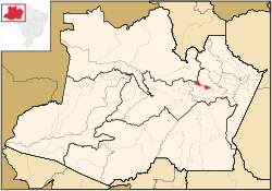 Location of Jutaí in the State of Amazonas | |
| Coordinates: 03°17′06″S 60°11′09″W / 3.28500°S 60.18583°W | |
| Country | |
| Region | North |
| State | |
| Emancipated | 1981 |
| Government | |
| • Mayor | Raymundo Nonato (PMDB) |
| Area | |
| • Total | 2,215.033 km2 (855.229 sq mi) |
| Elevation | 92 m (302 ft) |
| Population (2020) | |
| • Total | 49,011 |
| • Density | 18.94/km2 (49.1/sq mi) |
| [1] | |
| Time zone | UTC−4 (AMT) |
| Area code | +55 92 |
| HDI (2000) | 0.694 – medium[2] |
| Website | www.iranduba.am.gov.br |
Iranduba is a municipality located in the Brazilian state of Amazonas.
The population of Iranduba in 2020 was 49,011 and its area is 2,215 km2,[3] making it the smallest municipality in Amazonas in terms of area.
YouTube Encyclopedic
-
1/1Views:1 985
-
CACHOEIRA DO CASTANHO, MANAUS, IRANDUBA, AMAZONAS
Transcription
Geography
The municiaplity is located south and west of Manaus on the right bank of the Rio Negro and the left bank of the Solimões River. It is connected to Manaus by the Manaus Iranduba Bridge, a cable-stayed bridge which opened in 2011.
The municipality contains about 21% of the Rio Negro Right Bank Environmental Protection Area, a 1,140,990 hectares (2,819,400 acres) sustainable use conservation unit that controls use of an area of Amazon rainforest along the Rio Negro above the junction with the Solimões River.[4] It also contains about 80% of the Rio Negro Sustainable Development Reserve, a 103,086 hectares (254,730 acres) sustainable use conservation unit created in 2008 in an effort to stop deforestation in the area, which is threatened due to its proximity to Manaus.[5]
References
- ^ IBGE 2020
- ^ [1] Archived 2009-10-03 at the Wayback Machine - UNDP
- ^ IBGE - "Archived copy". Archived from the original on 2007-01-09. Retrieved 2014-08-03.
{{cite web}}: CS1 maint: archived copy as title (link) - ^ APA Margem Direita do Rio Negro (in Portuguese), ISA: Instituto Socioambiental, retrieved 2016-06-26
- ^ RDS do Rio Negro (in Portuguese), ISA: Instituto Socioambiental, retrieved 2016-06-27
Capital: Manaus | ||||||||||||||
| Mesoregion Centro Amazonense |
|  | ||||||||||||
| Mesoregion Norte Amazonense |
| |||||||||||||
| Mesoregion Sudoeste Amazonense |
| |||||||||||||
| Mesoregion Sul Amazonense |
| |||||||||||||
| International | |
|---|---|
| National | |
This article about a location in the Brazilian state of Amazonas is a stub. You can help Wikipedia by expanding it. |