
| Indiana Territory's at-large congressional district | |
|---|---|
| Obsolete district | |
| Created | 1805, as a non-voting delegate was granted by Congress |
| Eliminated | 1816, as a result of statehood |
| Years active | 1805–1816 |
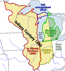
The Indiana Territory's at-large congressional district encompassed the entire area of the Indiana Territory.
A delegate to the United States Congress was elected from this district.
The territory was created from portions of the Northwest Territory leading up to the State of Ohio achieving statehood.
YouTube Encyclopedic
-
1/3Views:6 344 43864882 895
-
American Empire
-
Election 2016 Debate - NM 2nd Congressional District
-
The 55 States of America: U.S. Territories Explained
Transcription
The United States is, shockingly, a bunch of states that are united. It was just 13 to start with, but as time marched on, the border marked west, bringing us to today and the 48 contiguous states plus Alaska and Hawaii. They're usually drawn in these little boxes, not to to scale because Hawaii is in the middle of a vast ocean of deadly nothing-ness, and Alaska is monstrous. Unlike other unions, where members can leave if they so choose, statehood is eternal. Even for you, Texas. Now, how the federal government works is a story for another time, but at the moment, all you need know is that Congress, where national laws are written is made of representatives who are sent from the states. Now, there are some non-state gaps not visible on this map. The first is Washington D.C., the nation's capital. which is a stateless limbo land between Maryland and Virginia. As D.C. is a city without a state, it puts her under the control of Congress. Meaning all the other states get the final say on how D.C. is run, while she doesn't get a vote in anything. It didn't matter when the District of Columbia was basically uninhabited, but since more people live in D.C. now than do in a couple of states it's an uncomfortable arrangement. The other gaps on this map are the American Indian reservations. which are numerous. The United States kind of administers them while sort of treating them as foreign nations which means you could draw the state boundaries to look like this because the reservations are kind of apart from those states. But the American Indian reservations are such a full of asterisks (O' so sensitive situation) it's also better as a story for another time. Gaps aside, the continent (and Hawaii) is mostly straight-forward. But there's more than just these United States. When the U.S. ran out of lands to manifest destiny, she learned from the best and teritorified a whole bunch of islands. First up: Puerto Rico - an organized, unincorporated territory of the U.S. This means she's self-governing(to some extent) and that all the U.S. constitution doesn't automatically apply on the island. Now, 3.7 million people live in Puerto Rico which is 91% of the people living on U.S. Territorial islands and more people than live in 21 of the states. And, the U.S. treats Puerto Rico as a state in almost all but name which possibly soon she will be anyway bringing the number of stars to a nice, even, 51? But Puerto Rico isn't the only organized, unincorporated territory. There's also Guam, which was acquired in the Spanish-American war, along with Puerto Rico, there's the Northern Mariana Islands, taken from Japan during World War II, and the U.S. Virgin Islands taken from nobody -- Denmark sold her. The people in these territories are American citizens. In most ways, the territories are just like D.C. Congress can override their local governments and they don't have representation because no state-tation. But otherwise, it's America. Actually, the territories and D.C. do get to elect congressional representatives who attend all of the meetings but just can't vote in any of them. which is either the worst job in the world or the best job in the world depending on the kind of person who gets it. Also, since votes for president are based on state population, citizens in the territories can't vote. Which as mentioned in a previous video leads to the weird situation that Americans who live in foreign countries can vote for president in the state where they last lived. While Americans who live in America, just in a territory, cannot. Along with these unincorporated organized territories there are also unincorporated unorganized territories. Actually, quite a few. They are Howland Island, Navassa Island, Wake Island, Jarvis Island, Johnston Atoll, Kingman Reef, Midway Reef, Serranilla Bank and Bajo Nuevo Bank. Most of these were acquired under the delightfully named Guano Islands Act when the U.S. decided she wanted a bunch of islands filled with bird poop. No, really, the U.S. just straight up wrote a law to declare those islands were now hers. Unorganized, in this system, means there's no local government on these islands because no one lives in these places. Some of them are barley above the water line. Now, the weird category is unorganized incorporated territories of which there is one: the Palmyra Atoll. claimed by the U.S. after the totally peaceful annexation of Hawaii. They're currently an uninhabited nature reserve. But, incorporated means the U.S. constitution applies here. To who? The Palmyra Atoll is like that question about a tree falling in the forest. If there are no people for the constitution to apply to, does the constitution still apply? Yes. This means if a foreigner gives birth on this uninhabited strip and doesn't die from the nature, their child would be an American citizen. Now, this category is empty. It's where territories go before they become states. When basically the Constitution fully applies and it was last occupied by Hawaii. We've gone full circle but there is one territory we've left out -- American Samoa: home to 55,000 people. Uniquely, American Samoans don't get to be citizens but instead are American Nationals. They can live in the states but can't vote in presidential elections Unless they go through the immigration process like any foreigner. Even though in all other ways, they're indistinguishable from citizens. This is unique to American Samoa and there seems to be no reason for it other than that Congress has gotten around to updating the system. American Samoa is in the no-government category, like it's lord of the flies over there, which it obviously isn't. So American Samoa with it's organized government needs to go over here and Puerto Rico, essentially a state, needs to go over here and the empty Palmyra Atoll needs to go over here. But, don't hold your breath for the paperwork to make it's way through Congress any time soon. So, that's all the territories of the United States, but there is one final thing to talk about: three tiny nations -- Palu, the Marshall Islands and the Federated States of Micronesia. The last has a convenient domain name: .fm -- first choice of quality podcasts everywhere. *hint, hint; click, click* These are separate countries with UN seats and everything but they have a "Compact of Free Association" with the United States. The deal is that the U.S. provide economic support and military defense to the compact nations in return for being allowed to build military bases there. Also, compact citizens can live and work in the United States and vice versa. The Americans wanting to live abroad: you have three easy options. So, that's America: 50 states, many reservations, one district, lots of islands territories, some even with people and three tiny associated countries.
List of delegates representing the district
The territory sent one non-voting delegate to the United States House of Representatives.
| Delegate | Party | Years | Cong ress |
Electoral history |
|---|---|---|---|---|
 Benjamin Parke (Vincennes) |
Federalist | December 12, 1805 – March 1, 1808 |
9th 10th |
Elected in 1805. Re-elected September 3, 1807.[1] Resigned to serve on the staff of Governor of Indiana Territory.[2][3][4] |
| Vacant | March 1, 1808 – October 22, 1808 |
10th | ||
 Jesse Burgess Thomas (Lawrenceburg) |
Democratic-Republican | October 22, 1808 – March 3, 1809 |
Elected October 22, 1808 to finish the vacant term.[5] Moved to Illinois Territory. | |
| Vacant | March 4, 1809 – November 27, 1809 |
11th | ||
 Jonathan Jennings (Charlestown) |
Democratic-Republican | November 27, 1809 – December 11, 1816 |
11th 12th 13th 14th |
Elected in 1809.[6] Re-elected in 1811.[7] Re-elected in 1812.[8] Re-elected August 1, 1814.[9] Retired to become Governor of Indiana when statehood achieved. |
The area of Indiana Territory was reduced in 1805 by the creation of Michigan Territory, and again in 1809 by the creation of Illinois Territory.
Indiana becomes a state of the Union
On December 11, 1816, Indiana was admitted into the Union as a state.
See also
- United States congressional delegations from Northwest Territory
- List of United States congressional districts
References
- ^ A New Nation Votes
- ^ William Wesley Woollen (1975). Biographical and Historical Sketches of Early Indiana. Mid-American Frontier (reprint of 1883 ed.). New York: Arno Press. p. 384. OCLC 1218324.
- ^ "Parke, Benjamin". Federal Judicial Center. Retrieved November 27, 2017.
- ^ "Parke, Benjamin, (1777 – 1835)". Biographical Directory of Congress. United States Congress. Retrieved November 28, 2017.
- ^ A New Nation Votes
- ^ A New Nation Votes
- ^ A New Nation Votes
- ^ A New Nation Votes
- ^ A New Nation Votes
- "Our Campaigns - Container Detail Page". www.ourcampaigns.com. Retrieved September 16, 2020.
This United States Congress–related article is a stub. You can help Wikipedia by expanding it. |