To install click the Add extension button. That's it.

The source code for the WIKI 2 extension is being checked by specialists of the Mozilla Foundation, Google, and Apple. You could also do it yourself at any point in time.

4,5
Kelly Slayton
Congratulations on this excellent venture… what a great idea!
Alexander Grigorievskiy
I use WIKI 2 every day and almost forgot how the original Wikipedia looks like.
Live Statistics
English Articles
Improved in 24 Hours
Added in 24 Hours
What we do. Every page goes through several hundred of perfecting techniques; in live mode. Quite the same Wikipedia. Just better.
.
Leo
Newton
Brights
Milds

From Wikipedia, the free encyclopedia

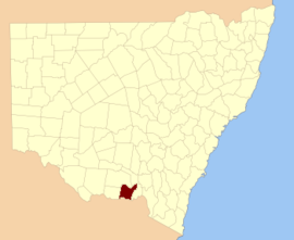
Map_of_Hume_County_(NSW)_Australia

Hume County is one of the 141 cadastral divisions of New South Wales. It contains the town of Culcairn.

Hume County was named in honour of the explorer Hamilton Hume (1797-1873).[1]

Parishes within this county

A full list of parishes found within this county; their current LGA and mapping coordinates to the approximate centre of each location is as follows:

Parish LGA Coordinates
Billabong Forest Federation Council 35°44′54″S 146°18′04″E / 35.74833°S 146.30111°E / -35.74833; 146.30111 (Billabong Forest)
Brocklesby Greater Hume Shire Council 35°47′54″S 146°39′04″E / 35.79833°S 146.65111°E / -35.79833; 146.65111 (Brocklesby)
Buckargingah Greater Hume Shire Council 35°29′54″S 147°09′04″E / 35.49833°S 147.15111°E / -35.49833; 147.15111 (Buckargingah)
Bulgandry Greater Hume Shire Council 35°35′12″S 146°38′19″E / 35.58667°S 146.63861°E / -35.58667; 146.63861 (Bulgandry)
Bungowannah Greater Hume Shire Council 36°00′54″S 146°48′04″E / 36.01500°S 146.80111°E / -36.01500; 146.80111 (Bungowannah)
Buraja Federation Council 35°52′54″S 146°24′04″E / 35.88167°S 146.40111°E / -35.88167; 146.40111 (Buraja)
Burrangong Federation Council 35°27′54″S 146°22′04″E / 35.46500°S 146.36778°E / -35.46500; 146.36778 (Burrangong)
Burrangong Federation Council 35°29′54″S 146°22′04″E / 35.49833°S 146.36778°E / -35.49833; 146.36778 (Burrangong)
Burrumbuttock Greater Hume Shire Council 35°48′54″S 146°47′04″E / 35.81500°S 146.78444°E / -35.81500; 146.78444 (Burrumbuttock)
Castlestead Greater Hume Shire Council 35°48′54″S 146°54′04″E / 35.81500°S 146.90111°E / -35.81500; 146.90111 (Castlestead)
Collendina Federation Council 35°58′54″S 146°14′04″E / 35.98167°S 146.23444°E / -35.98167; 146.23444 (Collendina)
Comer Greater Hume Shire Council 35°29′54″S 147°01′04″E / 35.49833°S 147.01778°E / -35.49833; 147.01778 (Comer)
Comer Greater Hume Shire Council 35°32′54″S 146°59′04″E / 35.54833°S 146.98444°E / -35.54833; 146.98444 (Comer)
Corowa Federation Council 35°57′44″S 146°21′44″E / 35.96222°S 146.36222°E / -35.96222; 146.36222 (Corowa)
Creighton Greater Hume Shire Council 35°42′54″S 147°01′04″E / 35.71500°S 147.01778°E / -35.71500; 147.01778 (Creighton)
Gibson Greater Hume Shire Council 35°39′54″S 146°37′04″E / 35.66500°S 146.61778°E / -35.66500; 146.61778 (Gibson)
Goombargana Greater Hume Shire Council 35°42′54″S 146°37′04″E / 35.71500°S 146.61778°E / -35.71500; 146.61778 (Goombargana)
Gordon Federation Council 35°38′54″S 146°19′04″E / 35.64833°S 146.31778°E / -35.64833; 146.31778 (Gordon)
Granville Federation Council 35°39′54″S 146°25′34″E / 35.66500°S 146.42611°E / -35.66500; 146.42611 (Granville)
Gray Federation Council 35°50′54″S 146°16′04″E / 35.84833°S 146.26778°E / -35.84833; 146.26778 (Gray)
Henty Greater Hume Shire Council 35°29′54″S 147°04′04″E / 35.49833°S 147.06778°E / -35.49833; 147.06778 (Henty)
Henty Greater Hume Shire Council 35°35′54″S 147°00′04″E / 35.59833°S 147.00111°E / -35.59833; 147.00111 (Henty)
Hindmarsh Greater Hume Shire Council 35°42′54″S 146°43′04″E / 35.71500°S 146.71778°E / -35.71500; 146.71778 (Hindmarsh)
Hovell Greater Hume Shire Council 35°52′54″S 146°45′04″E / 35.88167°S 146.75111°E / -35.88167; 146.75111 (Hovell)
Howlong Federation Council 35°57′54″S 146°39′04″E / 35.96500°S 146.65111°E / -35.96500; 146.65111 (Howlong)
Kentucky Federation Council 35°51′54″S 146°32′04″E / 35.86500°S 146.53444°E / -35.86500; 146.53444 (Kentucky)
Lowes Federation Council 35°46′54″S 146°25′04″E / 35.78167°S 146.41778°E / -35.78167; 146.41778 (Lowes)
Mahonga Forest Federation Council 35°31′54″S 146°29′04″E / 35.53167°S 146.48444°E / -35.53167; 146.48444 (Mahonga Forest)
Mahonga Federation Council 35°31′54″S 146°33′04″E / 35.53167°S 146.55111°E / -35.53167; 146.55111 (Mahonga)
Moorwatha Greater Hume Shire Council 35°55′00″S 146°44′59″E / 35.91667°S 146.74972°E / -35.91667; 146.74972 (Moorwatha)
Morebringer Greater Hume Shire Council 35°53′54″S 146°37′04″E / 35.89833°S 146.61778°E / -35.89833; 146.61778 (Morebringer)
Morven Greater Hume Shire Council 35°44′54″S 147°04′04″E / 35.74833°S 147.06778°E / -35.74833; 147.06778 (Morven)
Osborne Federation Council 35°37′54″S 146°31′04″E / 35.63167°S 146.51778°E / -35.63167; 146.51778 (Osborne)
Piney Range Greater Hume Shire Council 35°44′54″S 146°49′04″E / 35.74833°S 146.81778°E / -35.74833; 146.81778 (Piney Range)
Quat Quatta Federation Council 35°56′54″S 146°33′04″E / 35.94833°S 146.55111°E / -35.94833; 146.55111 (Quat Quatta)
Rand Federation Council 35°29′54″S 146°27′04″E / 35.49833°S 146.45111°E / -35.49833; 146.45111 (Rand)
Richmond Federation Council 35°46′54″S 146°32′04″E / 35.78167°S 146.53444°E / -35.78167; 146.53444 (Richmond)
Richmond Federation Council 35°44′54″S 146°30′04″E / 35.74833°S 146.50111°E / -35.74833; 146.50111 (Richmond)
Round Hill Greater Hume Shire Council 35°37′54″S 147°01′04″E / 35.63167°S 147.01778°E / -35.63167; 147.01778 (Round Hill)
Ryan Greater Hume Shire Council 35°35′54″S 146°44′04″E / 35.59833°S 146.73444°E / -35.59833; 146.73444 (Ryan)
Sandy Ridges Federation Council 35°53′54″S 146°16′04″E / 35.89833°S 146.26778°E / -35.89833; 146.26778 (Sandy Ridges)
Sherwyn Greater Hume Shire Council 35°38′54″S 146°50′04″E / 35.64833°S 146.83444°E / -35.64833; 146.83444 (Sherwyn)
Stitt Greater Hume Shire Council 35°37′54″S 146°56′04″E / 35.63167°S 146.93444°E / -35.63167; 146.93444 (Stitt)
Thugga Greater Hume Shire Council 35°05′54″S 147°07′04″E / 35.09833°S 147.11778°E / -35.09833; 147.11778 (Thugga)
Walbundrie Greater Hume Shire Council 35°39′54″S 146°44′04″E / 35.66500°S 146.73444°E / -35.66500; 146.73444 (Walbundrie)
Walla Walla Greater Hume Shire Council 35°43′54″S 146°54′04″E / 35.73167°S 146.90111°E / -35.73167; 146.90111 (Walla Walla)
Wilson Federation Council 35°32′54″S 146°19′04″E / 35.54833°S 146.31778°E / -35.54833; 146.31778 (Wilson)

References

  1. ^ "Hume County". Geographical Names Register (GNR) of NSW. Geographical Names Board of New South Wales. Edit this at Wikidata
This page was last edited on 4 May 2023, at 12:26
Basis of this page is in Wikipedia. Text is available under the CC BY-SA 3.0 Unported License. Non-text media are available under their specified licenses. Wikipedia® is a registered trademark of the Wikimedia Foundation, Inc. WIKI 2 is an independent company and has no affiliation with Wikimedia Foundation.