
| Hoxne | |
|---|---|
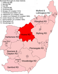 Location within East Suffolk, 1894 | |
| History | |
| • Created | 1894 |
| • Abolished | 1934 |
| • Succeeded by | Hartismere Rural District |
| Status | Rural district |
Hoxne Rural District was a rural district within the administrative county of East Suffolk between 1894 and 1934. It was created out of the earlier Hoxne rural sanitary district.[1] It was named after the historic hundred of Hoxne, whose boundaries it closely matched. The hundred, in turn, took its name from the village of Hoxne.
In 1934, under a County Review Order, Hoxne Rural District was abolished and its parishes transferred to Hartismere Rural District, and in 1974 to Mid Suffolk district. 3 parishes went into the new Blyth Rural District.
Statistics
| Year | Area[2] | Population [3] |
Density (pop/ha) | |
|---|---|---|---|---|
| acres | ha | |||
| 1911 | 52,842 | 21,385 | 10,408 | 0.49 |
| 1921 | 9,631 | 0.45 | ||
| 1931 | 9,045 | 0.42 | ||
Parishes
Parishes which would be transferred to Hartismere RD: Athelington, Bedfield, Bedingfield, Brundish, Denham, Fressingfield, Horham, Hoxne, Laxfield, Mendham, Metfield, Monk Soham, Southolt, Stradbroke, Syleham, Tannington, Weybread, Wilby, Wingfield, Worlingworth.
Transferred to Blyth RD: Badingham, Dennington, Saxtead
References
- ^ "Hoxne RD through time: Census tables with data for the Local Government District". A Vision of Britain through Time. GB Historical GIS / University of Portsmouth. Retrieved 9 July 2017.
- ^ "Hoxne RD through time: Population Statistics: Area (acres)". A Vision of Britain through Time. GB Historical GIS / University of Portsmouth. Retrieved 9 July 2017.
- ^ "Hoxne RD through time: Population Statistics: Total Population". A Vision of Britain through Time. GB Historical GIS / University of Portsmouth. Retrieved 9 July 2017.
52°18′N 1°17′E / 52.30°N 1.28°E
| Pre-1974 |
| ||||||
|---|---|---|---|---|---|---|---|
| Post-1974 | |||||||