
Horath | |
|---|---|
Location of Horath within Bernkastel-Wittlich district 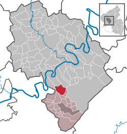 | |
 Horath  Horath | |
| Coordinates: 49°48′41.70″N 06°59′9.48″E / 49.8115833°N 6.9859667°E | |
| Country | Germany |
| State | Rhineland-Palatinate |
| District | Bernkastel-Wittlich |
| Municipal assoc. | Thalfang am Erbeskopf |
| Government | |
| • Mayor (2020–24) | Jan Steffes |
| Area | |
| • Total | 11.89 km2 (4.59 sq mi) |
| Elevation | 440 m (1,440 ft) |
| Population (2021-12-31)[1] | |
| • Total | 407 |
| • Density | 34/km2 (89/sq mi) |
| Time zone | UTC+01:00 (CET) |
| • Summer (DST) | UTC+02:00 (CEST) |
| Postal codes | 54497 |
| Dialling codes | 06504 |
| Vehicle registration | WIL |
Horath is an Ortsgemeinde – a municipality belonging to a Verbandsgemeinde, a kind of collective municipality – in the Bernkastel-Wittlich district in Rhineland-Palatinate, Germany.
Geography
Location
The municipality lies in the Hunsrück, in a hollow in the Dhron valley. Horath belongs to the Verbandsgemeinde of Thalfang am Erbeskopf, whose seat is in the municipality of Thalfang.
Neighbouring municipalities
Horath borders in the east on the municipality of Morbach (outlying centre of Haag), in the south on the municipalities of Merschbach and Gräfendhron, in the west on the municipalities of Berglicht and Neumagen-Dhron (outlying centre of Papiermühle) and in the north on the municipality of Piesport (outlying centre of Niederemmel).
History
Local finds from Hallstatt and La Tène times are displayed at the Trier Rhenish State Museum. The village had its first documentary mention in a pledge document from Count Heinrich at Salm issued on 1 December 1281. As a result of the turmoil of the French Revolution, Horath lay under French rule beginning about 1800. In 1814 it was assigned to the Kingdom of Prussia at the Congress of Vienna. Since 1947, it has been part of the then newly founded state of Rhineland-Palatinate.
Politics
Municipal council
The council is made up of 6 council members, who were elected by majority vote at the municipal election held on 7 June 2009, and the honorary mayor as chairman.[2]
Coat of arms
The municipality's arms might be described thus: Argent a cross gules surmounted by a two-handled jug Or.
Economy and infrastructure
Horath is a rural residential community. There are small businesses serving local demands.
Established businesses
In the Drahtwerk Horath (wireworks), however, Horath has an important industrial business as well.
References
External links
- Municipality’s official webpage (in German)
- Horath in the collective municipality’s Web pages (in German)

| International | |
|---|---|
| National | |
This Bernkastel-Wittlich location article is a stub. You can help Wikipedia by expanding it. |