
Hassa | |
|---|---|
District and municipality | |
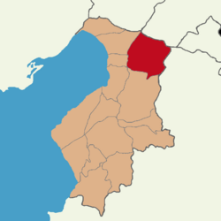 Map showing Hassa District in Hatay Province | |
 Hassa Location in Turkey | |
| Coordinates: 36°47′58″N 36°31′04″E / 36.79944°N 36.51778°E | |
| Country | Turkey |
| Province | Hatay |
| Government | |
| • Mayor | Mehmet Karataş (AKP) |
| Area | 520 km2 (200 sq mi) |
| Elevation | 430 m (1,410 ft) |
| Population (2022)[1] | 56,675 |
| • Density | 110/km2 (280/sq mi) |
| Time zone | TRT (UTC+3) |
| Postal code | 31700 |
| Area code | 0326 |
| Website | www |
Hassa is a municipality and district of Hatay Province, Turkey.[2] Its area is 520 km2,[3] and its population is 56,675 (2022).[1] It is on the eastern side of the Nur (Amanos) Mountains, looking towards the city of Gaziantep. It is on the Antakya-Malatya road. In the late 19th and early 20th century, Hassa was part of the Adana Vilayet of the Ottoman Empire. Hassa was a district in Cebel-i Bereket Province from 1923 to 1933 and then a part of Gaziantep Province until 1939.
Hassa is an olive-growing district. The trees were first brought there by Ottoman governor Derviş Paşa in the late 19th century. Hassa was heavily damaged by powerful earthquakes in February 2023 and subsequent aftershocks.[4] The same year it recorded the hottest temparature so far in Turkey as of 2023 at 50 °C (122 °F)[5]
YouTube Encyclopedic
-
1/1Views:4 449
-
Hassa Tarihi | 1500'lü Yıllarda Hassa'da ki Yerleşim Yerleri | Kargılık Nahiyesi
Transcription
Composition
There are 39 neighbourhoods in Hassa District:[6]
- 15 Kasım
- Akbez
- Akkülek
- Aktepe
- Ardıçlı
- Arpalıuşağı
- Aşağıkarafakılı
- Bademli
- Bintaş
- Buhara
- Çay
- Çınarbaşı
- Dedemli
- Demrek
- Dervişpaşa
- Eğribucak
- Gazeluşağı
- Girne
- Gülkent
- Gülpınar
- Güvenç
- Hacılar
- Haydarlar
- Katranlık
- Koruhüyük
- Küreci
- Mazmanlı
- Sapanözü
- Söğüt
- Sugediği
- Tepebaşı
- Tiyek
- Yeni
- Yeniyapan
- Yoluklar
- Yukarıbucak
- Yukarıkarafakılı
- Yuvalı
- Zeytinoba
References
- ^ a b "Address-based population registration system (ADNKS) results dated 31 December 2022, Favorite Reports" (XLS). TÜİK. Retrieved 19 September 2023.
- ^ Büyükşehir İlçe Belediyesi, Turkey Civil Administration Departments Inventory. Retrieved 19 September 2023.
- ^ "İl ve İlçe Yüz ölçümleri". General Directorate of Mapping. Retrieved 19 September 2023.
- ^ "Hatay'da ağır yıkımın bilançosu..." [The result of the heavy destruction in Hatay...] (in Turkish). Iskenderun.org. 2023-04-08.
- ^ "Turkey sets new national temperature record, soaring to 50 degrees celsius". Gazete Duvar. 2023-08-15. Retrieved 2023-11-30.
- ^ Mahalle, Turkey Civil Administration Departments Inventory. Retrieved 19 September 2023.
Hassa, Hatay in Hatay Province of Turkey | |||||||||||||||||||||||||||
|---|---|---|---|---|---|---|---|---|---|---|---|---|---|---|---|---|---|---|---|---|---|---|---|---|---|---|---|
| Districts |  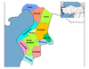 | ||||||||||||||||||||||||||
|
Metropolitan municipalities are bolded. | |||||||||||||||||||||||||||
This article about a Mediterranean Region of Turkey location is a stub. You can help Wikipedia by expanding it. |