
Hartselle, Alabama | |
|---|---|
 The Hartselle Downtown Commercial Historic District was added to the National Register of Historic Places on April 22, 1999. | |
 Flag  Seal | |
| Nickname: The City of Southern Hospitality | |
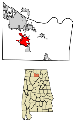 Location in Morgan County, Alabama | |
| Coordinates: 34°26′25″N 86°56′25″W / 34.44028°N 86.94028°W | |
| Country | United States |
| State | Alabama |
| County | Morgan |
| Established | 1869 |
| Government | |
| • Mayor | Randy Garrison |
| Area | |
| • Total | 16.73 sq mi (43.33 km2) |
| • Land | 16.64 sq mi (43.10 km2) |
| • Water | 0.09 sq mi (0.23 km2) 0.07% |
| Elevation | 673 ft (205 m) |
| Population | |
| • Total | 15,455 |
| • Density | 928.79/sq mi (358.62/km2) |
| Time zone | UTC-6 (CST) |
| • Summer (DST) | UTC-5 (CDT) |
| ZIP code | 35640 |
| Area code | 256 |
| FIPS code | 01-33448 |
| GNIS feature ID | 2403812[2] |
| Website | www |
Hartselle is the second largest city in Morgan County, Alabama, United States, 13 miles (21 km) south of Decatur. It is part of the Decatur Metropolitan Area and the Huntsville-Decatur Combined Statistical Area.
As of the 2020 census, the population of the city was 15,455.[3] Hartselle was founded in 1869 with the arrival of the South and North Alabama Railroad. It takes its name from George Hartsell, one of the railroad's owners. The post office opened in 1873. It was formally incorporated on March 1, 1875.[4] Most of the oldest buildings were destroyed by a disastrous fire in 1916.
YouTube Encyclopedic
-
1/4Views:1 873933570538
-
Hartselle Alabama Downtown drive
-
The New Farmer's Market | Hartselle, Alabama
-
111 McGovern Road Hartselle Alabama House For Sale
-
Hartselle, Alabama Oct, 2012
Transcription
Geography
Hartselle is located in western Morgan County at 34°26′25″N 86°56′25″W / 34.44028°N 86.94028°W (34.440383, -86.940385).[5] It is in the north-central part of the state along Interstate 65, which runs from south to north through the easternmost parts of the city, with access from exits 325 and 328. Via I-65, Huntsville is 34 miles (55 km) northeast (via a connection to I-565), and Birmingham is 70 miles (110 km) south. U.S. Route 31 is the main north-south highway through the center of town, leading north 13 miles (21 km) to Decatur, the Morgan county seat, and south 20 miles (32 km) to Cullman. Alabama State Route 36, Main Street, is the main east-west route through downtown, leading east 23 miles (37 km) to Lacey's Spring and west the same distance to Moulton.
According to the U.S. Census Bureau, the city of Hartselle has a total area of 16.7 square miles (43 km2), of which 0.1 square miles (0.26 km2), or 0.53%, are water.[1]
Demographics
| Census | Pop. | Note | %± |
|---|---|---|---|
| 1880 | 226 | — | |
| 1890 | 596 | 163.7% | |
| 1900 | 670 | 12.4% | |
| 1910 | 1,374 | 105.1% | |
| 1920 | 2,009 | 46.2% | |
| 1930 | 2,204 | 9.7% | |
| 1940 | 2,584 | 17.2% | |
| 1950 | 3,429 | 32.7% | |
| 1960 | 5,000 | 45.8% | |
| 1970 | 7,355 | 47.1% | |
| 1980 | 8,858 | 20.4% | |
| 1990 | 10,795 | 21.9% | |
| 2000 | 12,019 | 11.3% | |
| 2010 | 14,255 | 18.6% | |
| 2020 | 15,455 | 8.4% | |
| U.S. Decennial Census[6] | |||
2000 census
At the 2000 census there were 12,019 people, 4,816 households, and 3,534 families living in the city. The population density was 809.0 inhabitants per square mile (312.4/km2). There were 5,170 housing units at an average density of 348.0 per square mile (134.4/km2). The racial makeup of the city was 92.25% White, 5.16% Black or African American, 0.63% Native American, 0.31% Asian, 0.02% Pacific Islander, 0.33% from other races, and 1.31% from two or more races. 1.29% of the population were Hispanic or Latino of any race.[7]
Of the 4,814 households 35.5% had children under the age of 18 living with them, 59.1% were married couples living together, 10.9% had a female householder with no husband present, and 26.6% were non-families. 24.4% of households were one person and 11.2% were one person aged 65 or older. The average household size was 2.49 and the average family size was 2.97.
The age distribution was 25.5% under the age of 18, 7.7% from 18 to 24, 29.3% from 25 to 44, 23.5% from 45 to 64, and 14.0% 65 or older. The median age was 37 years. For every 100 females, there were 92.3 males. For every 100 females age 18 and over, there were 88.8 males.
The median household income was $40,461 and the median family income was $47,685. Males had a median income of $40,211 versus $24,124 for females. The per capita income for the city was $20,727. About 6.6% of families and 8.6% of the population were below the poverty line, including 8.8% of those under age 18 and 11.9% of those age 65 or over.
2010 census
At the 2010 census there were 14,255 people, 5,678 households, and 4,128 families living in the city. The population density was 956.7 inhabitants per square mile (369.4/km2). There were 6,076 housing units at an average density of 407.8 per square mile (157.5/km2). The racial makeup of the city was 91.5% White, 4.3% Black or African American, 0.8% Native American, 0.4% Asian, 0.0% Pacific Islander, 1.3% from other races, and 1.7% from two or more races. 2.5% of the population were Hispanic or Latino of any race.[8]
Of the 5,678 households 33.7% had children under the age of 18 living with them, 57.2% were married couples living together, 11.2% had a female householder with no husband present, and 27.3% were non-families. 24.4% of households were one person and 10.7% were one person aged 65 or older. The average household size was 2.51 and the average family size was 2.97.
The age distribution was 25.4% under the age of 18, 7.5% from 18 to 24, 26.2% from 25 to 44, 26.8% from 45 to 64, and 14.2% 65 or older. The median age was 38.7 years. For every 100 females, there were 93.2 males. For every 100 females age 18 and over, there were 93.7 males.
The median household income was $47,306 and the median family income was $57,585. Males had a median income of $47,343 versus $28,855 for females. The per capita income for the city was $21,746. About 9.4% of families and 11.7% of the population were below the poverty line, including 12.8% of those under age 18 and 14.9% of those age 65 or over.
2020 census
| Race | Num. | Perc. |
|---|---|---|
| White (non-Hispanic) | 13,380 | 86.57% |
| Black or African American (non-Hispanic) | 709 | 4.59% |
| Native American | 63 | 0.41% |
| Asian | 89 | 0.58% |
| Pacific Islander | 8 | 0.05% |
| Other/Mixed | 757 | 4.9% |
| Hispanic or Latino | 449 | 2.91% |
As of the 2020 United States census, there were 15,455 people, 5,518 households, and 3,930 families residing in the city.
Notable people
- Jill Alper, electoral strategist
- Wilford S. Bailey, former NCAA president and former Auburn University president
- Scott Beason, member of Alabama Senate from 2006 to 2014
- Jay Burleson, filmmaker
- William Bradford Huie, journalist, editor, publisher and author
- Don Logan, former chairman of Time Warner Media and Communications Group, owner of Bass Anglers Sportsman Society
- Mortal Treason, Christian metal band
- Harold Raley, American hispanist
- Tommy Ed Roberts, businessman and legislator
- Destin Sandlin, YouTuber and USAF engineer
- John Sparkman, congressman, senator, and 1952 vice-presidential nominee
- Steve Woodard, former MLB pitcher
- Robert H. York, U.S. Army lieutenant general[10]
References
- ^ a b "2021 U.S. Gazetteer Files". United States Census Bureau. Retrieved April 26, 2022.
- ^ a b U.S. Geological Survey Geographic Names Information System: Hartselle, Alabama
- ^ a b "Hartselle city, Alabama: 2020 DEC Redistricting Data (PL 94-171)". U.S. Census Bureau. Retrieved April 26, 2022.
- ^ on, Best Books (June 3, 2018). Alabama; a Guide to the Deep South. Best Books on. ISBN 9781623760014. Retrieved June 3, 2018 – via Google Books.
- ^ "US Gazetteer files: 2010, 2000, and 1990". United States Census Bureau. February 12, 2011. Retrieved April 23, 2011.
- ^ "U.S. Decennial Census". Census.gov. Retrieved June 6, 2013.
- ^ "U.S. Census website". United States Census Bureau. Retrieved January 31, 2008.
- ^ "U.S. Census website". United States Census Bureau. Retrieved August 5, 2015.
- ^ "Explore Census Data". data.census.gov. Retrieved December 17, 2021.
- ^ Sternberg, Ben; Straus, Jack M. (January 1991). "Death Notice, Robert Howard York". Assembly. West Point, NY: Association of Graduates, United States Military Academy. pp. 157–159 – via Google Books.
External links
Municipalities and communities of Morgan County, Alabama, United States | ||
|---|---|---|
| Cities |  | |
| Towns | ||
| Unincorporated communities | ||
| Ghost town | ||
| Former city | ||
| Former town | ||
| Footnotes | ‡This populated place also has portions in an adjacent county or counties | |
| International | |
|---|---|
| National | |
| Geographic | |