
Hanover | |
|---|---|
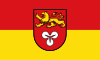 Flag  Coat of arms | |
 | |
| Country | Germany |
| State | Lower Saxony |
| Capital | Hanover |
| Government | |
| • District admin. | Steffen Krach (SPD) |
| Area | |
| • Total | 2,290 km2 (880 sq mi) |
| Population (31 December 2021)[1] | |
| • Total | 1,157,541 |
| • Density | 510/km2 (1,300/sq mi) |
| Time zone | UTC+01:00 (CET) |
| • Summer (DST) | UTC+02:00 (CEST) |
| Vehicle registration | H |
| Website | www |
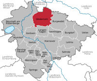
Hanover Region (German: Region Hannover) is a district in Lower Saxony, Germany. It is bounded by (from the north and clockwise) the districts of Heidekreis, Celle, Gifhorn, Peine, Hildesheim, Hamelin-Pyrmont, Schaumburg and Nienburg.
The Hanover Region district has a unique legal status among the districts of Lower Saxony. It includes the city of Hanover (the state capital) which has the same privileges as a city that is not part of a district. As a consequence, the district is much larger in population than any other district of the state. Its administrative body is the regional parliament (Regionsparlament), headed by the regional president (Regionspräsident), which since 2021 is Steffen Krach (SPD). The members of the regional parliament are elected once every five years and the regional president is elected also every five years in local elections.
YouTube Encyclopedic
-
1/5Views:3 36235070 91938 364419
-
Educating the Future: International School Hannover Region
-
Places to see in ( Hannover - Germany ) Erlebnis Zoo Hannover
-
D-Day Why was the casualty rate so high on Omaha compared to the other beaches? Normandy 6 June 1944
-
History: Seven Years' War
-
Lower Saxony
Transcription
History
The city of Hanover was not part of the district until 2001, when the old Hanover District (Landkreis Hannover) and the city then known officially as District-free City of Hanover (kreisfreie Stadt Hannover)[citation needed] were merged in order to form the new Hanover Region district, not to be confused with the former governmental district of Hanover (Regierungsbezirk Hannover).
During World War II, Hanover was the headquarters (Hauptquartier) of Military District XI (Wehrkreis XI), which was responsible for Braunschweig, Anhalt, and part of Hanover. It was also the garrison town for the 71st Infantry Division of the German Army.
Geography
The district surrounds the city of Hanover and includes the outskirts of its metropolitan area. The Leine river enters the district in the south, runs through Hanover and leaves to the north. In the northwest is the Steinhuder Meer, a lake with an area of 32 km2 (12 sq mi), within the region known as the Hanoverian Moor Geest.
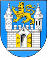
Coat of arms
The coat of arms was granted on May 1, 2003. The cloverleaf is from the arms of the city of Hanover. The lion was the heraldic animal of the Welfen family, which ruled the region from the Middle Ages until 1866.
Towns and municipalities

Towns
| Town | Capital | Area (km2) | Population (2015) | Location |
|---|---|---|---|---|
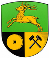
| Barsinghausen
|
Barsinghausen | 102.65 km2 | 33,608 |
|
| Burgdorf
|
Burgdorf | 112.26 km2 | 30,147 |
|
| Burgwedel
|
Burgwedel | 151.96 km2 | 20,654 |
|
| Garbsen
|
Garbsen | 79.31 km2 | 60,590 |
|
| Gehrden
|
Gehrden | 42.97 km2 | 14,624 |
|
| Hanover
|
Hanover | 204.01 km2 | 532,163 |
|
| Hemmingen
|
Hemmingen | 31.65 km2 | 18,793 |
|
| Laatzen
|
Laatzen | 34.05 km2 | 40,939 |
|
| Langenhagen
|
Langenhagen | 71.99 km2 | 53,323 |
|
| Lehrte
|
Lehrte | 127 km2 | 43,639 |
|
| Neustadt am Rübenberge
|
Neustadt am Rübenberge | 357 km2 | 43,931 |
|
| Pattensen
|
Pattensen | 67 km2 | 14,324 |
|
| Ronnenberg
|
Ronnenberg | 37.78 km2 | 23,752 |
|
| Seelze
|
Seelze | 54 km2 | 33,283 |
|
| Sehnde
|
Sehnde | 103.44 km2 | 23,489 |
|
| Springe
|
Springe | 159.78 km2 | 28,682 |
|
| Wunstorf
|
Wunstorf | 126.60 km2 | 41,251 |
|


Municipalities
| Municipalities | Capital | Area /km2 | Population (2015) | Location |
|---|---|---|---|---|
| Isernhagen
|
Isernhagen | 59.72 km2 | 23,792 |
|
| Uetze
|
Uetze | 140.56 km2 | 20,103 |
|
| Wennigsen
|
Wennigsen | 53.78 km2 | 14,036 |
|
| Wedemark
|
Wedemark | 173 km2 | 29,358 |
|


- Election results for the Regional Assembly since 2001
| Parties and voter associations | Prozent 2021 |
Sitze 2021 |
Prozent 2016 |
Sitze 2016 |
Prozent 2011 |
Sitze 2011 |
Prozent 2006 |
Sitze 2006 |
Prozent 2001 |
Sitze 2001 | |
|---|---|---|---|---|---|---|---|---|---|---|---|
| SPD | Sozialdemokratische Partei Deutschlands | 29,9 | 25 | 32,3 | 26 | 36,4 | 31 | 39,7 | 33 | 42,4 | 37 |
| CDU | Christlich Demokratische Union Deutschlands | 26,2 | 22 | 29,0 | 24 | 31,0 | 26 | 35,2 | 30 | 36,2 | 31 |
| Grüne | Bündnis 90/Die Grünen | 21,3 | 18 | 13,6 | 12 | 19,0 | 16 | 10,9 | 9 | 9,1 | 8 |
| FDP | Freie Demokratische Partei | 6,5 | 5 | 5,4 | 5 | 3,1 | 3 | 7,3 | 6 | 6,3 | 5 |
| AfD | Alternative für Deutschland | 5,1 | 4 | 10,1 | 9 | – | – | – | – | – | – |
| Linke | Die Linke | 3,6 | 3 | 4,8 | 4 | 2,5 | 3 | – | – | 1,4 | 1 |
| Tierschutz | Partei Mensch Umwelt Tierschutz | 1,7 | 1 | – | – | – | – | – | – | – | – |
| PARTEI | Partei für Arbeit, Rechtsstaat, Tierschutz, Elitenförderung und basisdemokratische Initiative | 1,6 | 1 | 0,9 | 1 | – | – | – | – | – | – |
| Basis | Grassroots Democratic Party of Germany (Basisdemokratische Partei Deutschland) | 1,0 | 1 | – | – | – | – | – | – | – | – |
| Piraten | Piratenpartei Deutschland | 0,9 | 1 | 1,6 | 1 | 3,0 | 2 | – | – | – | – |
| HAN | The Hanoverians | 0,8 | 1 | 1,9 | 2 | 2,7 | 2 | – | – | – | – |
| FW | Free Voters (Freie Wähler) | 0,8 | 1 | – | – | – | – | – | – | – | – |
| Volt | Volt Deutschland | 0,6 | 1 | – | – | – | – | – | – | – | – |
| BF | BürgerForum | – | – | – | – | 1,1 | 1 | 1,1 | 1 | – | – |
| BSG | Bündnis für Soziale Gerechtigkeit | – | – | – | – | 0,6 | 0 | 0,7 | 1 | – | – |
| REP | Die Republikaner | – | – | – | – | – | – | 1,5 | 1 | 1,4 | 1 |
| Sonstige | 0,2 | 0 | 1,5 | 0 | 1,6 | 0 | 3,8 | 3 | 3,1 | 1 | |
| Gesamt | 100 % | 84 | 100 % | 84 | 100 % | 84 | 100 % | 84 | 100 % | 84 | |
| Voter turnout | 54,7 % | 54,6 % | 49,7 % | 47,0 % | 52,3 % | ||||||
Inhabitants
| Year | Residents[2] |
|---|---|
| 2001 | 1,122,038 |
| 2005 | 1,128,543 |
| 2010 | 1,132,130 |
| 2015 | 1,144,481 |
| 2017 | 1,153,063 |
| 2018 | 1,157,624 |
See also
References
Further reading
- Official Map of the Region and State Capital Hannover
- Regional archive (in German)
- Hannover Umzüge (in German)
- Landesamt für Statistik Niedersachsen (in German)
External links
Towns and municipalities in Hanover Region | ||
|---|---|---|
 | ||
| Region | |
|---|---|
| Urban districts | |
| Rural districts |
|
52°25′12″N 9°43′12″E / 52.42000°N 9.72000°E
| International | |
|---|---|
| National | |