
12°39′0″N 10°35′30″E / 12.65000°N 10.59167°E
| Designations | |
|---|---|
| Official name | Nguru Lake (and Marma Channel) complex |
| Designated | 2 October 2000 |
| Reference no. | 1039[1] |
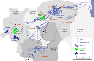
The Hadejia-Nguru wetlands in Yobe State in northern Nigeria, which include Nguru Lake, are ecologically and economically important. They are threatened by reduced rainfall in recent years, a growing population and upstream dam construction.
Geography
The wetlands lie in the Yobe-Komadugu sub-basin of the Chad Basin. They are formed where the Hadejia and Jama'are rivers meet lines of ancient sand dunes in a northeast–southwest alignment and break into numerous channels. They are drained by the Yobe River, which flows east towards Lake Chad. They lie between Sudanian Savanna to the south and the drier Sahel to the north. Some of the land is permanently flooded, while other parts are flooded only in the wet season (August and September).[2] Annual rainfall ranges between 200 and 600 mm, during the period late May–September.[3] At one time the wetlands may have covered up to 3,000 km2. Between 1964 and 1971 over 2,000 km2 were flooded. By 1983 less than 900 km2 were flooded, and less than 300 km2 were flooded in the drought year of 1984.[4]
Ecology

The Hadejia-Nguru wetlands are on the List of Ramsar wetlands of international importance. Nguru Lake and the Marma Channel complex (58,100 ha) are designated a Ramsar Site. The wetlands are important for waterbirds, both for breeding species and for wintering and passage Palearctic waterbirds. The estimated waterbird population varies between 200,000 and 325,000. 377 bird species have been seen in the wetlands, including occasional sightings of the near-threatened pallid harrier and great snipe species.[3]
The Bade-Nguru Wetlands sector of the Chad Basin National Park covers 938 km2 of the wetlands.[5] Parts of the wetlands are protected by five Forest Reserves, a Wildlife Sanctuary and a Ramsar Site. With reduced flooding and increasing population, the environment is degrading and there is growing competition between humans and wildlife. Farmers set out poison to kill the crop-destroying Quelea quelea, in the process killing non-target species. Marginal land is now coming under cultivation and tree cover in the forest reserves is being depleted.[3]
Economy
The area supports about 1.5 million farmers, herders and fishermen.[6] The wetlands support wet-season rice farming, flood-recession agriculture and dry-season farming using irrigation. Crops include peppers and wheat. The wetlands support fishermen, who often also farm, and provide fuel wood and leaves used for making mats and ropes. The lands are also grazed by Fulani cattle.[2]
Issues
The wetlands have suffered from increasingly severe droughts in recent years. Since the 1980s, the use of small gasoline-powered irrigation pumps has increased the land that can be used for farming, causing conflicts with the cattle herders and disputes over land ownership.[2]
Dams have threatened the viability of the wetlands, particularly the Tiga Dam and the Challawa Gorge Dam, which now control most of the water flow in the Hadejia river and have reduced seasonal flooding and overall water supply. It is estimated that the Tiga dam on the Kano river has reduced flooding by about 350 km2.[4] A dam was built on the Hadejia river just upstream from the wetlands for irrigation purposes, completed in 1972, which has also affected flooding. The proposed Kafin Zaki Dam on the Jama'are river could pose a further threat.[2] Due to these changes, large areas of farming and grazing land and important fish ponds have either dried up along channels blocked by invasive Typha grass, or have been flooded.[6][7]
See also
External links
- G.E. Hollis, W.M. Adams & M. Aminu-Kano The Hadejia-Nguru Wetlands-Environment, Economy and Sustainable Development of a Sahelian Floodplain Wetland. 1993. (Contents page)
References
- ^ "Nguru Lake (and Marma Channel) complex". Ramsar Sites Information Service. Retrieved 25 April 2018.
- ^ a b c d "Irrigation potential in Africa: A basin approach - The Hadejia-Nguru wetlands". United Nations Food and Agriculture Organization. Retrieved 2009-10-04.
- ^ a b c "Important Bird Area factsheet: Hadejia-Nguru wetlands, Nigeria". BirdLife International. Archived from the original on 2015-09-24. Retrieved 2012-02-14.
- ^ a b "FISH SPECIES DIVERSITY IN THE MAJOR NATURAL LAKES, WETLANDS AND THEIR INFLOWING RIVERS". United Nations Food and Agriculture Organization. Retrieved 2009-10-04.
- ^ "Chad Basin National Park". Nigeria National Park Service. Archived from the original on 2011-07-27. Retrieved 2010-11-03.
- ^ a b "WOW Demonstration Project: Hadeija Nguru Wetlands, Nigeria". Wings over Wetlands. Retrieved 2009-10-04.
- ^ "Typha Grass". Hadejia Emirate Web site. Archived from the original on October 20, 2007. Retrieved 2014-05-25.