
Höfen | |
|---|---|
 Coat of arms | |
Location of Höfen  | |
 Höfen  Höfen | |
| Coordinates: 46°43′N 7°33′E / 46.717°N 7.550°E | |
| Country | Switzerland |
| Canton | Bern |
| District | Thun |
| Area | |
| • Total | 4.62 km2 (1.78 sq mi) |
| Elevation | 705 m (2,313 ft) |
| Highest elevation (Stockbeissern) | 833 m (2,733 ft) |
| Lowest elevation | 641 m (2,103 ft) |
| Population (Dec 2011) | |
| • Total | 444 |
| • Density | 96/km2 (250/sq mi) |
| Time zone | UTC+01:00 (Central European Time) |
| • Summer (DST) | UTC+02:00 (Central European Summer Time) |
| Postal code(s) | 3631 |
| SFOS number | 0930 |
| Surrounded by | Niederstocken, Oberstocken, Reutigen, Zwieselberg, Amsoldingen, Übeschi and Pohlern |
| Website | www SFSO statistics |
Höfen is a former municipality in the administrative district of Thun in the canton of Bern in Switzerland. On 1 January 2014 the former municipalities of Höfen, Niederstocken and Oberstocken merged into the new municipality of Stocken-Höfen.[1]
YouTube Encyclopedic
-
1/2Views:1 188309
-
Burgen und Schlösser der Schweiz - Burg Stocken (Jagdburg), Höfen - Kanton Bern
-
Tschernobil Belastung viel weniger auf Demeter Höfen
Transcription
Geography
Before the merger, Höfen had a total area of 4.6 km2 (1.8 sq mi).[2] Of this area, 3.42 km2 (1.32 sq mi) or 74.2% is used for agricultural purposes, while 0.74 km2 (0.29 sq mi) or 16.1% is forested. Of the rest of the land, 0.27 km2 (0.10 sq mi) or 5.9% is settled (buildings or roads), 0.1 km2 (25 acres) or 2.2% is either rivers or lakes and 0.08 km2 (20 acres) or 1.7% is unproductive land.[3]
Of the built up area, housing and buildings made up 2.8% and transportation infrastructure made up 2.8%. 14.5% of the total land area is heavily forested and 1.5% is covered with orchards or small clusters of trees. Of the agricultural land, 23.9% is used for growing crops and 48.2% is pastures, while 2.2% is used for orchards or vine crops. All the water in the municipality is in lakes. Of the unproductive areas, 1.7% is unproductive vegetation.[3]
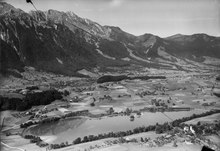
The lake Uebeschisee is located partially in the former municipality.
Demographics
Höfen had a population (as of 2011) of 444.[2] As of 2007[update], 2.1% of the population was made up of foreign nationals. Over the last 10 years the population has decreased at a rate of -3.5%. Most of the population (as of 2000[update]) speaks German (98.7%), with French being second most common ( 0.3%) and Rhaeto-romance being third ( 0.3%).
In the 2007 election the most popular party was the SVP which received 49.6% of the vote. The next three most popular parties were the Green Party (12.3%), the SPS (11.6%) and the local small left-wing parties (10.7%).
The age distribution of the population (as of 2000[update]) is children and teenagers (0–19 years old) make up 29.4% of the population, while adults (20–64 years old) make up 59.3% and seniors (over 64 years old) make up 11.3%. The entire Swiss population is generally well educated. In Höfen about 77.7% of the population (between age 25-64) have completed either non-mandatory upper secondary education or additional higher education (either university or a Fachhochschule).
Höfen has an unemployment rate of 0.92%. As of 2005[update], there were 65 people employed in the primary economic sector and about 26 businesses involved in this sector. 9 people are employed in the secondary sector and there are 3 businesses in this sector. 56 people are employed in the tertiary sector, with 10 businesses in this sector.[2] The historical population is given in the following table:[4]
| year | population |
|---|---|
| 1764 | 184 |
| 1850 | 456 |
| 1900 | 342 |
| 1930 | 291 |
| 1950 | 341 |
| 2000 | 398 |
References
- ^ Nomenklaturen – Amtliches Gemeindeverzeichnis der Schweiz (in German) accessed 13 December 2014
- ^ a b c "Key figures: Regional portraits 2013: Communes" (2013) Swiss Federal Statistical Office pages 1917–1918, accessed 12 October 2015
- ^ a b Swiss Federal Statistical Office-Land Use Statistics 2009 data (in German) accessed 25 March 2010
- ^ Höfen in German, French and Italian in the online Historical Dictionary of Switzerland.
External links
- Official website of the municipality in (in German)
- Höfen, Thun in German, French and Italian in the online Historical Dictionary of Switzerland.