
| Gucha - Migori Kuja | |
|---|---|
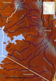 Gucha River (center left) | |
| Location | |
| Country | Kenya |
| Physical characteristics | |
| Source | |
| • location | Nyamira County |
| • coordinates | 0°33′50″S 34°59′38″E / 0.563813°S 34.993856°E |
| Mouth | Lake Victoria |
• location | Migori County |
• coordinates | 0°54′18″S 34°08′38″E / 0.905°S 34.144°E |
| Length | 149[1] km (93 mi) |
| Basin size | 6,900[1][2] km2 (2,700 sq mi) |
| Discharge | |
| • average | 58[1] m3/s (2,000 cu ft/s) |
| Basin features | |
| Tributaries | |
| • left | Sare River, Oyani River, Migori River, Ongoche River |
| • right | Riana River |
Gucha River, referred to as the River Kuja by Luo community originates in the highlands of Kiabonyoru in Nyamira County passing through the heart of Gucha District running west through Migori country where it is joins the Migori River and flows as the Kuja-Migori River into Lake Victoria.
As it runs across the Gusii Land part of it becomes the Mogonga River, known for its deadly effects when it floods. Mogonga and Gucha are almost equal in size and they meet just 1 mile before flowing through the Ogembo Town center.
The Gucha-Migori river changed its course near its mouth in 2001-2002, moving north to its present location.[1]
About 45 km from Migori, the Gogo Falls dam was completed in 1956 with a hydropower capacity of 2MW, connected to the Kenyan national grid.[2] The dam is operated by Kenya Electricity Generating Company (Kengen).[3] In 2014, Kenyan government announced an upgrade to the dam, to increase capacity to 12MW, regulate flow to prevent flooding, and allow irrigation of approximately 25,000ha.[4] As of February 2016, the Orango irrigation intake and canals have been built downstream of the dam for the use of Okenge and Owiro farmers in Migori County, but construction of distributary channels have been delayed.[5]
The Gogo Falls archaeological site is located near the dam.
YouTube Encyclopedic
-
1/3Views:2 0941 136399
-
Musa Ka Musallah (Winter Survival)
-
Musa ka Musallah Winter Expedition Jan 2017
-
husam musa yellow river publishing
Transcription
References
- ^ a b c d WRMA and JICA (July 2014). "Appendix 3-4 Gucha Migori River Basin Integrated Flood Management Plan Draft" (PDF). Archived from the original (PDF) on 4 December 2016. Retrieved 4 December 2016.
- ^ a b Lake Basin Development Authority (June 2008). "PROPOSAL FOR A FEASIBILITY STUDY ON KUJA RIVER MULTIPURPOSE PROJECT" (PDF). Archived from the original (PDF) on 2016-12-04. Retrieved 4 December 2016.
- ^ "HYDRO POWER STATIONS". www.kengen.co.ke. Archived from the original on 17 April 2016. Retrieved 4 December 2016.
- ^ "Government to boost energy capacity of Gogo Falls". Standard Digital News. February 2014. Retrieved 4 December 2016.
- ^ "Endless wait for irrigation water dampens Nyatike farmers' hopes". Kenya News Agency. February 2016. Archived from the original on 20 December 2016. Retrieved 4 December 2016.