
Grodno Region
| |
|---|---|
From the top to bottom-right: Mir Castle Complex, St. Francis Xavier Cathedral, Sviack Palace, Vawkavysk District, Devil's Lake | |
 Flag  Coat of arms | |
 | |
| Country | Belarus |
| Administrative center | Grodno |
| Largest cities | Grodno - 373,547[1] Lida - 101,616 Slonim - 49,441 |
| Districts | 17 Cities: 12 Urban localities: 21 |
| City districts | 2 |
| Government | |
| • Chairman | Vladimir Karanik[2] |
| Area | |
| • Total | 25,118.07 km2 (9,698.14 sq mi) |
| Highest elevation | 323 m (1,060 ft) |
| Lowest elevation | 80 m (260 ft) |
| Population (2023)[3] | |
| • Total | 998,600 |
| • Density | 40/km2 (100/sq mi) |
| GDP | |
| • Total | Br 23.4 billion (€6.9 billion) |
| • Per capita | Br 22,600 (€6,300) |
| ISO 3166 code | BY-HR |
| HDI (2021) | 0.805[5] very high · 3rd |
| Website | www |
 | |


Grodno Region or Hrodna Region,[7] also known as Grodno Oblast or Hrodna Voblasts (Belarusian: Гродзенская вобласць, romanized: Hrodzienskaja voblasć; Russian: Гродненская область, romanized: Grodnenskaya oblast; Polish: Obwód Grodzieński), is one of the regions of Belarus. Its administrative center, Grodno, is the largest city in the region.
Located in western Belarus, it lies on the Neman River. The region borders Minsk Region to the east, Brest Region to the south, Poland (Podlaskie Voivodeship) to the west and Vitebsk Region and Lithuania (Alytus and Vilnius counties) to the north. Grodno's existence is attested to from 1127. Two castles dating from the 14th to 18th centuries are located here on the steep right bank of the Nemen. One of the city's surviving masterpieces is the 12th century Orthodox Church of St Boris & St Gleb (Kalozhskaya Church), which is the second oldest in Belarus.
YouTube Encyclopedic
-
1/3Views:7932 7642 540
-
Welcome to Grodno Region. Mosty, the Town of Bridges
-
Western Belarus Sightseeing - Grodno Region - 2017
-
A History of Grodno - Final Bastion of the Commonwealth
Transcription
History
This region comprised the westernmost "borderlands" of the Early East Slavs (tribal union Dregoviches?) on the lands of the Balts in the 6th-9th centuries CE. In the 12th-14th centuries it formed part of the area sometimes known as Black Ruthenia, which the rulers of Lithuania fully incorporated into the Grand Duchy of Lithuania (GDL) in the 13th century.
In 1413, the area around the town of Grodno, part of the Duchy of Trakai, was transformed into newly established Trakai Voivodeship. Per the Union of Horodło, Grodno became the seat of Grodno County. In 1441, Magdeburg Law charter was granted to the capital by Casimir IV Jagiellon Grand Duke of Lithuania and future King of Poland. In 1444, Grodno received its coat of arms from Casimir's hands as well as substantial trading privileges.
The strong economic development of the area continued during the reign of Casimir's son - Duke Alexander Jagiellon of Lithuania (r. 1492–1506), who founded the first solid bridge over the Neman River as well as the Monastery of the Order of Saint Augustine and the Monastery of the Polish Ordo Fratrum Minorum. Later, Bona Sforza, Queen consort of Poland and Grand Duchess consort of Lithuania between 1518 and 1548, established her royal residence in Grodno. According to medieval surveys, Grodno had 35 streets and 700 houses in 1558.
The golden age of Grodno came with the reign of Stephen Báthory, King of Poland from 1576 to 1586. During his reign, Grodno became a royal headquarters and began to host sessions of Polish–Lithuanian Commonwealth Senate and Parliament. In 1580, on the king's order, the castle of Grodno was rebuilt in Renaissance style of architecture by Scoto di Parma.
At the beginning of the 17th century, Grodno, one of the most developed and important cities in Polish–Lithuanian Commonwealth, was traditionally recognized as the third capital of the commonwealth. Deterioration of the province's status began with the Livonian War of 1558 to 1583, which pitted the Polish–Lithuanian Commonwealth and the Swedish Empire in a lengthy and exhausting military conflict against the Tsardom of Russia. Between 1765 and 1780, the province regained some of its previous status when Antoni Tyzenhaus, the Treasurer of the Grand Duchy of Lithuania and Administrator of Polish Royal Estates, governed the capital and the province. Tyzenhaus fostered around 50 new commercial endeavours in the region with the building of manufactures, mills and workshops.
As part of the Polish-Lithuanian Commonwealth forming the Grand Duchy's Trakai Voivodship, and due to subsequent Partitions of Poland, the whole of the Grodno region was finally annexed by the Russian Empire by the end of 1795. The city of Grodno then became a seat for the Grodno Governorate.
During World War I the governorate was occupied by Germany. German troops entered Grodno city on 3 September 1915, plundering the Library of Dominicans Order. During the German occupation, Polish citizens of Grodno region were persecuted and had restricted civil rights. Towards the end of the war, the Belarusian People's Republic (BNR) declared its independence from Soviet Russia in March 1918 in Minsk. Grodno was the site of the last stand of the BNR's Council (Rada). Soon, the council was forced to flee as Soviet troops invaded the region and the city in 1919. The same year the Polish–Soviet War broke out; it continued until 1921.
Under the terms of Peace Treaty of Riga the region and the city returned to Second Polish Republic which claimed rights to this territory as a successor to Polish–Lithuanian Commonwealth and as a victorious side of the Polish–Soviet War. By 1939, the Grodno city had 60,000 inhabitants, with Poles and Jews accounting for 60% and 37% of the population, respectively. During Polish rule Grodno was centre of Grodno County in Białystok Voivodeship, but some parts of present Grodno Region was in the voivodeships of Nowogródek and Wilno.
After World War II started, on 17 September 1939, the Grodno area was invaded by Soviet Union and incorporated by force to the Soviet Union as part of the Byelorussian Soviet Socialist Republic. Grodno was located in the newly established Belastok Region. Thousands were imprisoned or deported to Siberia or Kazakhstan.[why?] In the early summer of 1941 the region fell under Nazi German occupation. In November 1941, German occupants established the Grodno Ghetto for Jewish citizens of Grodno and rest of the region population. In 1942, after a year of severe persecution and planned starvation of ghetto inhabitants, 10,000 Jews from Grodno were deported to the German concentration camp of Auschwitz-Birkenau and murdered there. Next year, in 1943, survivors of remaining 17,000 of ghetto inhabitants were again deported to Auschwitz-Birkenau as well as to Treblinka extermination camp and Białystok Ghetto. Although on 13 March 1943, German troops reported the end of extermination and described Grodno city as judenrein, around 50 Jews survived the extermination, also hidden by non-Jewish families. Polish and Soviet underground acted in the region. Villages like Dziarečyn, which originally had large Jewish populations, were greatly reduced.
As a result of Joseph Stalin's policy of expansion to the west, it was decided during the Yalta Conference that the Polish eastern border shall be set along the so-called "original" Curzon Line. Based on this decision, the left-bank part of Grodno town would be kept within the borders of Poland. It is actually not clear till today, how the original Curzon Line near Grodno has been moved by around 20 km to the west. When the so-called "mistake" (today regarded rather as sabotage within British ministry structures) became obvious to negotiators, Stalin refused to correct the mistaken line. Despite multiple and desperate appeals from Polish citizens of Grodno, the whole Grodno region, (including ethically Polish till today) Sapotskin Triangle, was incorporated to the Soviet Belarus and many Poles emigrated or were expelled.[citation needed]
In 1944, Belastok Region was dissolved and Grodno Region established.
Since 1991, the Grodno Region constitutes one of six regions of independent Belarus.
Heritage and tourism
Main tourist attractions in the region are numerous old architectural constructions such as castles in Mir, Lida, Novogrudok. A part of Białowieża Forest is situated here, but the tourist excursions start from the Brest Region part of the National Park. Zhyrovichy Monastery is also a destination for religious travellers. The Mir Castle Complex and Belovezhskaya Pushcha National Park are UNESCO World Heritage Sites. There are such objects of Belarusian Cultural heritage list, as the Church of Saint Anthony of Padua in Kamienka, St. Francis Xavier Cathedral, St Andrew's Church in Slonim, Church of the Holy Trinity in Hyervyaty, etc.
There are about 45 travel agencies in Grodno Region, half of them provide agent activity, the other half are tour operators.[8][9]
Demographics
The province covers an area of 25,100 km2 and has a population of 1,065,100, giving a population density of 42/km2.[10] About 63.5% live in cities and towns, while 36.5% live in rural areas. Females account for 53% of the region's population and men 47%. There are about 310,000 children under 19, and about 240,000 people aged over 60.
Nowadays, Belarusians account for 62.3% of the population. The region is a home to significant minority populations.
Demographics 1930
- Poles (60.5%)
- Jews (37.5%)
- Belarusians (0.5%)
- Russians (0.5%)
- Ukrainians (0.2%)
- Lithuanians (0.2%)
- Tatars (0.2%)
- Lithuanians (0.2%)
- other nationalities (0.2%)
Demographics 2002
- Belarusians (62.3%)
- Poles (24.8%),
- Russians (10%),
- Ukrainians (1.8%),
- Jews (0.4%),
- Tatars (0.2%),
- Lithuanians (0.2%),
- other nationalities (0.4%).
Whereas Belarus as a whole is primarily Russian Orthodox, Grodno Region has two major religions, Roman Catholic and Russian Orthodox. There are 449 religious communities and 18 denominations, 2 Russian Orthodox eparchial districts, 1 Orthodox nun sorority, 2 Catholic monk brotherhoods, 1 Catholic nun sorority, 2 Orthodox and 4 Catholic monasteries, 165 Orthodox and 169 Catholic churches. The Catholic minority[citation needed] is made up mostly[citation needed] of Poles, although the identifier "Pole" has also been historically applied to Catholic Belarusians.
There are a number on national minority associations: 6 Polish, 6 Lithuanian, 4 Jewish, 1 Ukrainian, 1 Russian, 1 Tatar, 1 Georgian, 1 Chuvash.
-
 Belarusians in the region>90%80–90%70–80%60–70%50–60%40–50%<40%
 -
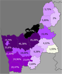 Poles in the region>50%30–50%20–30%10–20%5–10%2–5%<2%
 -
 Russians in the region>10%8–10%5–8%<5%


Administrative subdivisions
The Grodno Region is subdivided into 17 districts (rajons), 194 selsoviets, 12 cities, 6 city municipalities, and 21 urban-type settlements.
Districts of Grodno Region
Cities and towns

Population of cities and towns in Grodno Region:[3][11]
| English | Belarusian | Pop. (2023) | Pop. (2018) |
|---|---|---|---|
| Grodno | Гродна | 358,717 | 373,547 |
| Lida | Ліда | 103,915 | 101,616 |
| Slonim | Слонім | 49,113 | 49,441 |
| Vawkavysk | Ваўкавыск | 41,991 | 44,004 |
| Smarhon | Смаргонь | 35,781 | 37,527 |
| Novogrudok | Навагрудак | 28,021 | 29,424 |
| Ashmyany | Ашмяны | 16,870 | 16,875 |
| Shchuchyn | Шчучын | 15,653 | 15,475 |
| Masty | Масты | 14,683 | 15,838 |
| Astravyets | Астравец | 14,805 | 10,878 |
| Skidzyelʹ | Скідзель | 9,742 | 10,713 |
| Byarozawka | Бярозаўка | 9,657 | 10,311 |
| Dzyatlava | Дзятлава | 7,881 | 7,624 |
| Iwye | Іўе | 7,243 | 7,702 |
| Svislach | Свiслач | 6,098 | 6,426 |
Economy

In 2016, Grodno Region produced 10.9% of industrial output of Belarus.[12] The biggest company was a nitrogen fertilizer producer Grodno Azot (16% of regional industrial output).[13] In 2017, the biggest taxpayer of the region was Grodno tobacco factory.[14]
Average salary (before income tax) in the region in 2017 was 700 BYN, or lower than average salary in Belarus (820 BYN). The highest salary in the region was recorded in Grodno (810 BYN).[15]
Unemployment rate in 2017 was estimated at 4.4%, but only 0.8% of population of employable age was registered as unemployed.[16]
See also
- Second Polish Republic’s Nowogródek Voivodeship (1919-1939)
- Second Polish Republic’s Białystok Voivodeship (1919–1939)
- Second Polish Republic’s Wilno Voivodeship (1926–39)
References
- ^ "Численность населения по г. Гродно и районам Гродненской области на 1 января каждого года с 1996 по 2019гг./Population of Grodno and rayons of the Grodno Region" (in Russian). grodno.belstat.gov.by. 1 January 2019.
- ^ "Лукашенко принял решение назначить Караника губернатором Гродненской области, областные депутаты поддержали". 22 August 2020.
- ^ a b "Численность населения на 1 января 2023 г. и среднегодовая численность населения за 2022 год по Республике Беларусь в разрезе областей, районов, городов, поселков городского типа". belsat.gov.by. Archived from the original on 17 April 2023. Retrieved 17 October 2023.
- ^ "Gross domestic product and gross regional product by regions and Minsk city in 2023". www.belstat.gov.by.
- ^ "Sub-national HDI - Area Database - Global Data Lab". hdi.globaldatalab.org. Retrieved 2018-09-13.
- ^ Highest point: Zamkovaya Mountain
Lowest point: Spot were the Neman
crosses the country's border - ^ Official transliteration from Belarusian language (2007)
- ^ Ministry of Sports and Tourism of the Republic of Belarus. (2011). "Number of organizations engaged in tourist activities in 2010 in Belarus". Land of Ancestors. National Statistical Committee of the Republic of Belarus. Retrieved 9 October 2013.
- ^ Ministry of Sports and Tourism of the Republic of Belarus. (2011). "Number of organisations engaged in tourist activities in Belarus by region". Land of Ancestors. National Statistical Committee of the Republic of Belarus. Retrieved 9 October 2013.
- ^ "Main Geographic Characteristics of the Republic of Belarus. Territory and population density of Belarus by region as of January 1, 2011". Land of Ancestors. The Scientific and Production State Republican Unitary Enterprise “National Cadastre Agency” of the State Property Committee of the Republic of Belarus. 2011. Retrieved 24 September 2013.
- ^ "Численность населения по городам Гродненской области на 1 января 2018 года/Population of citiea and towns of the Grodno Region on the 1st of January 2018" (in Russian). www.belstat.gov.by. 1 January 2018.
- ^ Industry of Belarus [Промышленность Республики Беларусь]. — Minsk: National Statistics Committee of Belarus, 2017. — P. 39.
- ^ "Промышленность". Archived from the original on 2013-12-27. Retrieved 2019-06-26.
- ^ "Самым крупным налогоплательщиком в Гродненской области стала табачная фабрика "Неман"". Archived from the original on 2019-06-26. Retrieved 2019-06-26.
- ^ Regions of the Republic of Belarus [Регионы Республики Беларусь]. — Vol. 1. — Minsk: National Statistics Committee of Belarus, 2018. — P. 191—194.
- ^ Regions of the Republic of Belarus [Регионы Республики Беларусь]. — Vol. 1. — Minsk: National Statistics Committee of Belarus, 2018. — P. 165—168.
External links
- Grodno Regional Executive Committee Archived 2006-05-16 at the Wayback Machine, in Belarusian, Russian, English and Chinese
| Districts (raiony) |  | |
|---|---|---|
| District centres | ||
| Cities and towns | ||
| National | |
|---|---|
| Geographic | |
53°45′N 25°20′E / 53.750°N 25.333°E