
Groß Pankow | |
|---|---|
 Coat of arms | |
Location of Groß Pankow (Prignitz) within Prignitz district  | |
 Groß Pankow  Groß Pankow | |
| Coordinates: 53°07′00″N 12°03′00″E / 53.11667°N 12.05000°E | |
| Country | Germany |
| State | Brandenburg |
| District | Prignitz |
| Subdivisions | 18 Ortsteile |
| Government | |
| • Mayor (2016–24) | Marco Radloff[1] |
| Area | |
| • Total | 248.79 km2 (96.06 sq mi) |
| Elevation | 60 m (200 ft) |
| Population (2021-12-31)[2] | |
| • Total | 3,746 |
| • Density | 15/km2 (39/sq mi) |
| Time zone | UTC+01:00 (CET) |
| • Summer (DST) | UTC+02:00 (CEST) |
| Postal codes | 16928; 19348 |
| Dialling codes | 033983 |
| Vehicle registration | PR |
| Website | www.grosspankow.de |


Groß Pankow (Prignitz) is a municipality in Prignitz district, Brandenburg, Germany. The municipality was formed in 2001 from the union of municipalities of the former Amt of Groß Pankow/Prignitz and some in Amt Pritzwalk-Land. Amt Groß Pankow/Prignitz was then dissolved.[3]
From 1815 to 1945, the constituent localities of Groß Pankow were part of the Prussian Province of Brandenburg. From 1952 to 1990, they were part of the Bezirk Potsdam of East Germany.
Groß Pankow is connected via German Federal Highway B 189 to the cities of Pritzwalk, Perleberg, Wittenberge and Magdeburg.


YouTube Encyclopedic
-
1/3Views:2 5885514 195
-
PERLEBERG OLD TOWN & ABANDONED SOVIET ARMY BARRACKS BRANDENBURG GERMANY EUROPE
-
Quitzow Stadt Perleberg Kreis Prignitz 8.8.2013
-
Tour Brandenburg - Von Perleberg bis Wittstock ("...viele Perlen...")
Transcription
Geography
The municipality has 39 villages in 18 districts[4] with the populations given in parentheses (As of March 1, 2010)[5]
|
|
Demography
-
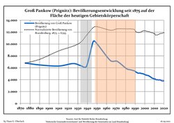
Development of population since 1875 within the current Boundaries (Blue Line: Population; Dotted Line: Comparison to Population development in Brandenburg state; Grey Background: Time of Nazi Germany; Red Background: Time of communist East Germany)
-
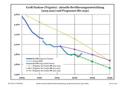
Recent Population Development and Projections (Population Development before Census 2011 (blue line); Recent Population Development according to the Census in Germany in 2011 (blue bordered line); Official projections for 2005-2030 (yellow line); for 2017-2030 (scarlet line); for 2020-2030 (green line)


|
|
|
Personalities

- Carl von Karstedt (1811-1888), conservative Reichstag deputy, born in Kleinlinde
- Erhard Hübener (1881-1958), DDP and LDPD politician, born in Tacken
- Richard Kackstein (1903-1966), national socialist politician, born in Triglitz
- Joachim Wüstenberg (1908-1993), hygienist in Gelsenkirchen, born in Klenzenhof
References
- ^ Landkreis Prignitz Wahl der Bürgermeisterin / des Bürgermeisters, accessed 2 July 2021.
- ^ "Bevölkerungsentwicklung und Flächen der kreisfreien Städte, Landkreise und Gemeinden im Land Brandenburg 2021" (PDF). Amt für Statistik Berlin-Brandenburg (in German). June 2022.
- ^ Amtsblatt für Brandenburg - Gemeinsames Ministerialblatt für das Land Brandenburg, 13. Jahrgang, Nummer 25, 19. Juni 2002, p.607 PDF Archived 2014-02-22 at the Wayback Machine.
- ^ Hauptsatzung der Gemeinde Groß Pankow (Prignitz) vom 2. April 2009 PDF[permanent dead link]
- ^ "Grosspankow.de - Einwohnerzahlen".
- ^ Detailed data sources are to be found in the Wikimedia Commons.Population Projection Brandenburg at Wikimedia Commons
Towns and municipalities in Prignitz | ||
|---|---|---|
 | ||
| International | |
|---|---|
| National | |
This Brandenburg location article is a stub. You can help Wikipedia by expanding it. |