
Gotvand County
Persian: شهرستان گتوند | |
|---|---|
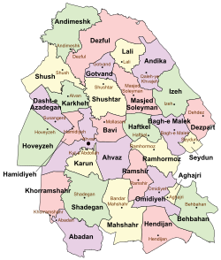 Location of Gotvand County in Khuzestan province (top center, purple) | |
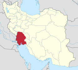 Location of Khuzestan province in Iran | |
| Coordinates: 32°17′N 48°49′E / 32.283°N 48.817°E[1] | |
| Country | |
| Province | Khuzestan |
| Capital | Gotvand |
| Districts | Central, Aghili |
| Population (2016)[2] | |
| • Total | 65,468 |
| Time zone | UTC+3:30 (IRST) |
Gotvand County (Persian: شهرستان گتوند) is in Khuzestan province, Iran. Its capital is the city of Gotvand.[3]
YouTube Encyclopedic
-
1/2Views:438759
-
Iran Anar valley, Gotvand county, Nature & Tourism attractions طبيعت و گردشگري دره انار گتوند
-
Iran Razi village, Ramian county, Nature & People lifestyle طبيعت و زندگي مردم روستاي رضي راميان
Transcription
Demographics
Population
At the time of the 2006 National Census, the county's population was 58,311 in 11,440 households.[4] The following census in 2011 counted 64,951 people in 14,975 households.[5] At the 2016 census, the county's population was 65,468 in 16,901 households.[2]
Administrative divisions
Gotvand County's population history and administrative structure over three consecutive censuses are shown in the following table.
| Administrative Divisions | 2006[4] | 2011[5] | 2016[2] |
|---|---|---|---|
| Central District | 40,206 | 44,703 | 46,210 |
| Jannat Makan RD | 16,029 | 3,791 | 4,757 |
| Kiyaras RD | 2,749 | 4,291 | 4,568 |
| Gotvand (city) | 21,428 | 22,822 | 24,216 |
| Jannat Makan (city) | 6,020 | 5,360 | |
| Saleh Shahr (city)[a] | 7,779 | 7,309 | |
| Aghili District | 18,105 | 19,416 | 18,853 |
| Aghili-ye Jonubi RD | 7,690 | 8,120 | 7,673 |
| Aghili-ye Shomali RD | 10,415 | 4,036 | 3,708 |
| Somaleh (city) | 1,606 | 1,784 | |
| Torkalaki (city) | 5,654 | 5,688 | |
| Total | 58,311 | 64,951 | 65,468 |
| RD = Rural District | |||
See also
![]() Media related to Gotvand County at Wikimedia Commons
Media related to Gotvand County at Wikimedia Commons
Notes
References
- ^ OpenStreetMap contributors (31 July 2023). "Gotvand County" (Map). OpenStreetMap. Retrieved 31 July 2023.
- ^ a b c "Census of the Islamic Republic of Iran, 1395 (2016)". AMAR (in Persian). The Statistical Center of Iran. p. 06. Archived from the original (Excel) on 21 October 2020. Retrieved 19 December 2022.
- ^ Aref, Mohammad Reza (12 December 2013). "Divisional changes and reforms in Khuzestan province". Laws and Regulations Portal of the Islamic Republic of Iran (in Persian). Ministry of Interior, Political and Defense Commission. Archived from the original on 5 June 2022. Retrieved 9 August 2023.
- ^ a b "Census of the Islamic Republic of Iran, 1385 (2006)". AMAR (in Persian). The Statistical Center of Iran. p. 06. Archived from the original (Excel) on 20 September 2011. Retrieved 25 September 2022.
- ^ a b "Census of the Islamic Republic of Iran, 1390 (2011)". Syracuse University (in Persian). The Statistical Center of Iran. p. 06. Archived from the original (Excel) on 18 January 2023. Retrieved 19 December 2022.
- ^ Davodi, Parviz (18 September 1386). "The transformation of the village of Shahrak-e Shahid Chamran from Jannat Makan Rural District in the Central District of Gotvand County in Khuzestan province to Saleh Shahr". Qavanin (in Persian). Ministry of Interior, Political and Defense Commission. Archived from the original on 31 July 2023. Retrieved 31 July 2023.

| Capital | |||||||||||||||||||||
|---|---|---|---|---|---|---|---|---|---|---|---|---|---|---|---|---|---|---|---|---|---|
| Districts |
| ||||||||||||||||||||
This Khuzestan province location article is a stub. You can help Wikipedia by expanding it. |