
Gmina Czarny Dunajec
Czarny Dunajec Commune | |
|---|---|
 Flag  Coat of arms | |
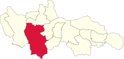 Location of Gmina Czarny Dunajec in Nowy Targ County. | |
 Gmina Czarny Dunajec Location of Gmina Czarny Dunajec in Lesser Poland Voivodeship.  Gmina Czarny Dunajec Gmina Czarny Dunajec (Lesser Poland Voivodeship) | |
| Coordinates (Czarny Dunajec): 49°26′22″N 19°51′15″E / 49.43944°N 19.85417°E | |
| Country | |
| Voivodeship | Lesser Poland |
| County | Nowy Targ |
| Seat | Czarny Dunajec |
| Government | |
| • Wójt | Marcin Ratułowski |
| Area | |
| • Total | 218.34 km2 (84.30 sq mi) |
| Population (2020) | |
| • Total | 22,592[1] |
| • Density | 103.47/km2 (268.0/sq mi) |
| Website | http://www.czarny-dunajec.pl |
Gmina Czarny Dunajec is a rural gmina (administrative district) in Nowy Targ County, Lesser Poland Voivodeship, in southern Poland, on the Slovak border. Its seat is the village of Czarny Dunajec, which lies approximately 13 kilometres (8 mi) west of Nowy Targ and 70 km (43 mi) south of the regional capital Kraków.
The gmina covers an area of 218.34 square kilometres (84.3 sq mi), and as of 2020 its total population is 22,592.[1]
YouTube Encyclopedic
-
1/3Views:7 085468958
-
Gmina Czarny Dunajec z lotu ptaka.
-
Prezentacja Gminy Czarny Dunajec
-
Czarny Dunajec - ul. Kmietowicza w strone lasu
Transcription
Villages
Gmina Czarny Dunajec contains the villages and settlements of Chochołów, Ciche, Czarny Dunajec, Czerwienne, Dział, Koniówka, Odrowąż, Piekielnik, Pieniążkowice, Podczerwone, Podszkle, Ratułów, Stare Bystre, Wróblówka and Załuczne.
Neighbouring gminas
Gmina Czarny Dunajec is bordered by the gminas of Biały Dunajec, Jabłonka, Kościelisko, Nowy Targ, Poronin, Raba Wyżna and Szaflary. It also borders Slovakia.
References
- ^ a b GUS. "Ludność. Stan i struktura ludności oraz ruch naturalny w przekroju terytorialnym (stan w dniu 31.12.2020)". stat.gov.pl (in Polish). Retrieved 2021-06-23.
| Seat | ||
|---|---|---|
| Other villages | ||
| Urban gminas |
|  |
|---|---|---|
| Urban-rural gminas | ||
| Rural gminas | ||