

Glenelg, Mars (or Glenelg Intrigue) is a location on Mars near the Mars Science Laboratory (Curiosity rover) landing site (Bradbury Landing) in Gale Crater marked by a natural intersection of three kinds of terrain.[1][2]
YouTube Encyclopedic
-
1/1Views:2 084
-
Planet Mars: Five Views on What Is Known - 1993 Educational Documentary - WDTVLIVE42
Transcription
Name
The location was named Glenelg by NASA scientists for two reasons: all features in the immediate vicinity were given names associated with Yellowknife in northern Canada, and Glenelg is the name of a geological feature there. Furthermore, the name is a palindrome, and as the Curiosity rover is planned to visit the location twice (once coming, and once going) this was an appealing feature for the name.[3] The original Glenelg is a village in Scotland which on 20 October 2012 had a ceremony, including a live link to NASA, to celebrate their "twinning" with Glenelg on Mars.[4]
The trek to Glenelg will send the rover 400 m (1,300 ft) east-southeast of its landing site. One of the three types of terrain intersecting at Glenelg is layered bedrock, which is attractive as the first drilling target.[citation needed]
Images
-

First-year and first-mile traverse map of the Curiosity rover on Mars (1 August 2013) (3-D).
-

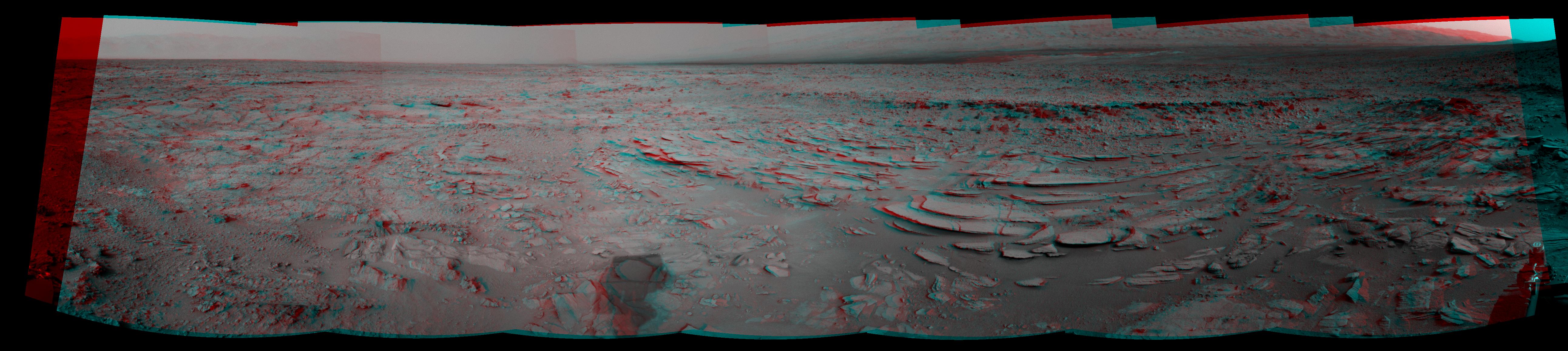
Curiosity's view of the Glenelg Area – where three terrains merge (19 September 2012).
-

-

-

"Shaler" rock outcrop near the Glenelg Area on Mars - as viewed by the MastCam on the Curiosity rover (7 December 2012).


![Curiosity's view of the "Shaler" rock outcrop (foreground) near the Glenelg Area [NNW/left; West/center; SSW/right] (7 December 2012) (3-D).](/wikipedia/commons/thumb/2/2f/PIA16551-MarsCuriosityRover-ShalerOutcrop-20121207.jpg/im824-1024px-PIA16551-MarsCuriosityRover-ShalerOutcrop-20121207.jpg)
![Curiosity's view of rocks looking from "Rocknest" toward "Point Lake" on the way to the Glenelg Area [East/center] (26 November 2012; white balanced) (raw color).](/wikipedia/commons/thumb/9/9a/PIA16453-MarsCuriosityRover-RocknestPanorama-20121126.jpg/im824-1024px-PIA16453-MarsCuriosityRover-RocknestPanorama-20121126.jpg)

See also
- Aeolis Mons
- Aeolis Palus
- Aeolis quadrangle
- Bedrock
- Composition of Mars
- Geology of Mars
- List of rocks on Mars
- Rock outcrop
- Timeline of Mars Science Laboratory
- Water on Mars
References
- ^ Mars Curiosity Rover First Road Trip Planned, archived from the original on 20 August 2012
- ^ NASA Curiosity Team Pinpoints Site for First Drive 08.17.12
- ^ Marlow, Jeffrey (23 August 2012). "Glenelg: From the Scottish Highlands to Mars".
- ^ Holgate, Alastair. "Glenelg Scotland, twinned with Mars". The Glenelg and Arnisdale Tourist Information Guide. Glenelg and Arnisdale Tourist Information. Archived from the original on 28 April 2016.
External links
| General |  | |
|---|---|---|
| Instruments | ||
| Features | ||
| Sites | ||
| Rocks | ||
| Related | ||
| Geography | |||||||||||
|---|---|---|---|---|---|---|---|---|---|---|---|
| Astronomy |
| ||||||||||
| Exploration |
| ||||||||||
| Related | |||||||||||