
Georgios Karaiskakis
Γεώργιος Καραϊσκάκης | |
|---|---|
 Georgios Karaiskakis Location within the region 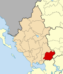 | |
| Coordinates: 39°10′N 21°11′E / 39.167°N 21.183°E | |
| Country | Greece |
| Administrative region | Epirus |
| Regional unit | Arta |
| Area | |
| • Municipality | 463.9 km2 (179.1 sq mi) |
| • Municipal unit | 174.2 km2 (67.3 sq mi) |
| Population (2021)[1] | |
| • Municipality | 5,278 |
| • Density | 11/km2 (29/sq mi) |
| • Municipal unit | 1,978 |
| • Municipal unit density | 11/km2 (29/sq mi) |
| Time zone | UTC+2 (EET) |
| • Summer (DST) | UTC+3 (EEST) |
| Postal code | 470 48 |
| Vehicle registration | ΑΤ |
Georgios Karaiskakis (Greek: Γεώργιος Καραϊσκάκης) is a municipality in the regional unit of Arta, Greece, named after Georgios Karaiskakis, a leader of the Greek War of Independence. The seat of the municipality is in Ano Kalentini.[2]
YouTube Encyclopedic
-
1/3Views:6 40630 2821 346
-
Η Αράχωβα Βοιωτίας από ψηλά - Traditional village of Arachova, drone video
-
90 ΧΡΟΝΙΑ ΠΑΟΚ. ΝΟΣΤΑΛΓΩΝΤΑΣ ΤΟ ΜΕΛΛΟΝ. Ολόκληρο το βίντεο. (+English subtitles)
-
To Grow Greek Tourism Online στη Σαντορίνη
Transcription
Municipality
The present municipality Georgios Karaiskakis was formed at the 2011 local government reform by the merger of the following 3 former municipalities, that became municipal units:[2]
- Georgios Karaiskakis
- Irakleia
- Tetrafylia
The municipality has an area of 463.889 km2, the municipal unit 174.179 km2.[3]
References
- ^ "Αποτελέσματα Απογραφής Πληθυσμού - Κατοικιών 2021, Μόνιμος Πληθυσμός κατά οικισμό" [Results of the 2021 Population - Housing Census, Permanent population by settlement] (in Greek). Hellenic Statistical Authority. 29 March 2024.
- ^ a b "ΦΕΚ A 87/2010, Kallikratis reform law text" (in Greek). Government Gazette.
- ^ "Population & housing census 2001 (incl. area and average elevation)" (PDF) (in Greek). National Statistical Service of Greece. Archived from the original (PDF) on 2015-09-21.
| Regional unit of Arta | 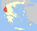 | |
|---|---|---|
| Regional unit of Ioannina | ||
| Regional unit of Preveza | ||
| Regional unit of Thesprotia | ||
| ||
This Epirus location article is a stub. You can help Wikipedia by expanding it. |