


Melbourne, the capital city of Victoria, Australia, is situated on the southeastern fringe of the Australian landmass and in the southern central part of the state. Melbourne covers an urbanised area (generally excluding nearby rural areas) of approximately 2,453 km2–larger than that of Sydney, Greater London and Mexico City,[1] with population density roughly around 16 people per hectare on average.[1][2][3]
The city itself is situated in a region of alpine forests known as the High Country. The city and metropolitan areas of Melbourne also spans along the lower stretches of the Yarra River. Towards eastern Melbourne is the low-lying mountain ranges known as Dandenong Ranges, 35 km east of the city.
YouTube Encyclopedic
-
1/3Views:8652 230 741283 283
-
COVID 19 and Geography - What it means for Melbourne
-
Geography Now! Australia
-
Sydney and Melbourne Compared
Transcription
Geology
Geologically, it is built on the conclusion of Quaternary lava flows to the west, Silurian mudstones to the east, and Holocene sand accumulation to the southeast along Port Phillip. The southeastern suburbs are situated on the Selwyn fault which transects Mount Martha and Cranbourne.
Topography

Melbourne extends along the Yarra River towards the Yarra Valley and the Dandenong Ranges to the east. It extends northward through the undulating bushland valleys of the Yarra's tributaries—Moonee Ponds Creek (toward Tullamarine Airport), Merri Creek, Darebin Creek and Plenty River—to the outer suburban growth corridors of Craigieburn and Whittlesea. The western part of the metropolitan area lies within the Victorian Volcanic Plain Grasslands biome.[4][5] The southeastern suburbs (from Frankston) are situated within the Gippsland Plains Grassy Woodland zone.[6]
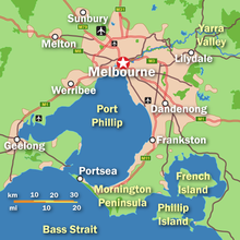
The city reaches south-east through Dandenong to the growth corridor of Pakenham towards West Gippsland, and southward through the Dandenong Creek valley, the Mornington Peninsula and the city of Frankston taking in the peaks of Olivers Hill, Mount Martha and Arthurs Seat, extending along the shores of Port Phillip as a single conurbation to reach the exclusive suburb of Portsea and Point Nepean.
In the west, it extends along the Maribyrnong River and its tributaries north towards Sunbury and the foothills of the Macedon Ranges, and along the flat volcanic plain country towards Melton in the west, Werribee at the foothills of the You Yangs granite ridge and Geelong as part of the greater metropolitan area to the south-west.
Coast
Melbourne's major bayside beaches are located in the south-eastern suburbs along the shores of Port Phillip Bay, in areas like Port Melbourne, Albert Park, St Kilda, Elwood, Brighton, Sandringham, Mentone and Frankston although there are beaches in the western suburbs of Altona and Williamstown. The nearest surf beaches are located 85 kilometres (53 mi) south-west of the Melbourne CBD in the back-beaches of Rye, Sorrento and Portsea.[7][8]
See also

References
- ^ a b "Australian cities among the largest and least densely settled in the world". architectureau.com. 20 April 2017. Retrieved 6 May 2020.
- ^ Mees, Paul (22 November 2009). "We can keep our leafy suburbs and still save the planet". The Age. Retrieved 14 June 2020.
- ^ "How big is Melbourne?". The Melbourne Urbanist. 25 March 2010. Retrieved 14 June 2020.
- ^ Victorian Volcanic Plains by Greening Australia. Retrieved 3 September 2022.
- ^ Biodiversity of the Western Volcanic Plains - The Western Volcanic Plains State of Victoria (Department of Education). Retrieved 3 September 2022.
- ^ Gippsland Red Gum Grassy Woodland and Associated Native Grassland Environment Protection and Biodiversity Conservation Act 1999. Retrieved 6 September 2022.
- ^ Russell, Mark (2 January 2006). "Life's a beach in Melbourne". Sydney Morning Herald. Retrieved 29 September 2008.
- ^ "BEACH REPORT 2007–08" (PDF). epa.vic.gov.au. Archived from the original (PDF) on 1 October 2008. Retrieved 29 September 2008.