
Gais | |
|---|---|
| Gemeinde Gais Comune di Gais | |
 Neuhaus Castle | |
 Coat of arms | |
Location of Gais  | |
 Gais Location of Gais in Italy  Gais Gais (Trentino-Alto Adige/Südtirol) | |
| Coordinates: 46°50′N 11°57′E / 46.833°N 11.950°E | |
| Country | Italy |
| Region | Trentino-Alto Adige/Südtirol |
| Province | South Tyrol (BZ) |
| Frazioni | Lanebach (Lana di Gais), Mühlbach (Riomolino), Tesselberg (Montassilone) and Uttenheim (Villa Ottone) |
| Government | |
| • Mayor | Christian Gartner (SVP) |
| Area | |
| • Total | 60.3 km2 (23.3 sq mi) |
| Elevation | 841 m (2,759 ft) |
| Population (Nov. 2010)[2] | |
| • Total | 3,162 |
| • Density | 52/km2 (140/sq mi) |
| Demonym(s) | German:Gaiser Italian: di Gais |
| Time zone | UTC+1 (CET) |
| • Summer (DST) | UTC+2 (CEST) |
| Postal code | 39030 |
| Dialing code | 0474 |
| Website | Official website |

Gais (Italian pronunciation: [ˈɡais]; German pronunciation: [ˈgaɪ̯s]) is a comune (municipality) and a village in South Tyrol in northern Italy, located about 60 kilometres (37 mi) north-east of the city of Bolzano.
YouTube Encyclopedic
-
1/5Views:5 8776 9101 2894 849403
-
What to do in BRUNECK, ITALY with Tourismuszukunft!!
-
Südtirol unter Eis - Eine Spurensuche
-
Marco Bonatta - Photography - Image Stock Sample of South Tyrol
-
Bruneck / Brunico in Pustertal - local south tyrolian commercial center walk in HD
-
Alto Adige gennaio 2011
Transcription
Geography
As of 30 November 2010, it had a population of 3,162 and an area of 60.3 km2 (23.3 sq mi).[3]
Gais is one of the three communes of South Tyrol whose name, for the reason of sounding "romantic", remained unchanged by the early 20th century renaming programme which aimed at replacing mostly German place names with Italianised versions, the other two being Plaus and Lana.[4]
Gais borders the following municipalities: Bruneck, Sand in Taufers, Pfalzen, Percha, and Mühlwald.
Frazioni
The municipality of Gais contains the frazioni (subdivisions, mainly villages and hamlets) Lanebach (Lana di Gais), Mühlbach (Riomolino), Tesselberg (Montassilone) and Uttenheim (Villa Ottone).
History
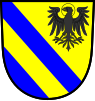
Coat-of-arms
The emblem is party per bend or and azure with two bendlets azure; the remaining field represents a sable eagle with a halo and the head facing left. The eagle symbolizes John the Evangelist which the parish church is dedicated and the two azure bendlets the two castles Kehlburg and Neuhaus. The emblem was adopted in 1956.[5]
International relations
Twin towns — Sister cities
Gais is twinned with:
 Coburg, Germany
Society
Linguistic distribution
According to the 2011 census, 97.05% of the population speak German, 2.65% Italian and 0.29% Ladin as first language.[6]
Demographic evolution

References
- ^ "Superficie di Comuni Province e Regioni italiane al 9 ottobre 2011". Italian National Institute of Statistics. Retrieved 16 March 2019.
- ^ "Popolazione Residente al 1° Gennaio 2018". Italian National Institute of Statistics. Retrieved 16 March 2019.
- ^ All demographics and other statistics: Italian statistical institute Istat.
- ^ Olt, Reinhard (28 September 2000). "Am Eisack (Isarco) und an der Etsch (Adige) Namen in Südtirol wecken nationale Leidenschaften". Frankfurter Allgemeine Zeitung.
- ^ Heraldry of the World: Gais
- ^ "Volkszählung 2011/Censimento della popolazione 2011". astat info. Provincial Statistics Institute of the Autonomous Province of South Tyrol (38): 6–7. June 2012. Retrieved 2012-06-14.
External links
- (in German and Italian) Homepage of the municipality
![]() Media related to Gais, South Tyrol at Wikimedia Commons
Media related to Gais, South Tyrol at Wikimedia Commons

| International | |
|---|---|
| National | |
| Geographic | |