
Furubira
古平町 | |
|---|---|
Town | |
 Furubira Town hall | |
 Flag  Emblem | |
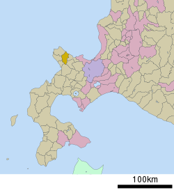 Location of Furubira in Hokkaido (Shiribeshi Subprefecture) | |
 Furubira Location in Japan | |
| Coordinates: 43°16′N 140°38′E / 43.267°N 140.633°E | |
| Country | Japan |
| Region | Hokkaido |
| Prefecture | Hokkaido (Shiribeshi Subprefecture) |
| District | Furubira |
| Government | |
| • Mayor | Junji Homma |
| Area | |
| • Total | 188.41 km2 (72.75 sq mi) |
| Population (30 September 2016) | |
| • Total | 3,265 |
| • Density | 17/km2 (45/sq mi) |
| Time zone | UTC+09:00 (JST) |
| City hall address | 40-4 Hama-machi, Furubira, Furubira-gun, Hokkaido 046-0192 |
| Website | www |
Furubira (古平町, Furubira-chō) is a town located in Shiribeshi Subprefecture, Hokkaido, Japan. As of September 2016, the town had an estimated population of 3,265, and a density of 17 persons per km2. The total area is 188.41 square kilometres (72.75 sq mi).[1][2]
Geography
Furubira occupies the eastern end of the north coast of the Shakotan Peninsula facing the Sea of Japan. The town is largely built around the Furubira River, which runs from the highlands of the Shakotan Peninsula into the sea.[1]
Neighboring municipalities
History
Furubira was established as one of many Pacific herring fishing settlements in the region at the beginning of the Edo period (1603 – 1868). The town was formally incorporated in 1902.[1]
Economy
Manganese was once mined at the head of the Furubira River; mining ceased in the town in 1984. The mine was located at Inakuraishi.
The Port of Furubira, located near Cape Maruyama, is an active fishing port. Shrimp, Alaska pollack, and saltwater clams are a mainstay of the economy. The Furubira River provides irrigation for the production of rice, potatoes, and soybeans. Beef, pork, and poultry are also raised in the town.[1]
Education
Hokkaido Furubira High School closed in 2012.
- Furubira Elementary School
- Furubira Junior High School
References
- ^ a b c d "古平(町)" [Furubira]. Nihon Daihyakka Zensho (Nipponika) (in Japanese). Tokyo: Shogakukan. 2013. OCLC 153301537. Archived from the original on 25 August 2007. Retrieved 22 July 2013.
- ^ 人口と世帯 [Population and households] (in Japanese). Furubira, Hokkaido, Japan: Town of Furubira. 2013. Retrieved 28 August 2013.
External links
 Media related to Furubira, Hokkaidō at Wikimedia Commons
- Official Website (in Japanese)
| ||||||||||||
| ||||||||||||
| ||||||||||||
| ||||||||||||
| ||||||||||||
| ||||||||||||
| ||||||||||||
| ||||||||||||
| ||||||||||||
| ||||||||||||
| ||||||||||||
| ||||||||||||
| ||||||||||||
| ||||||||||||
| International | |
|---|---|
| National | |
This Hokkaidō location article is a stub. You can help Wikipedia by expanding it. |