To install click the Add extension button. That's it.

The source code for the WIKI 2 extension is being checked by specialists of the Mozilla Foundation, Google, and Apple. You could also do it yourself at any point in time.

4,5
Kelly Slayton
Congratulations on this excellent venture… what a great idea!
Alexander Grigorievskiy
I use WIKI 2 every day and almost forgot how the original Wikipedia looks like.
Live Statistics
English Articles
Improved in 24 Hours
Added in 24 Hours
What we do. Every page goes through several hundred of perfecting techniques; in live mode. Quite the same Wikipedia. Just better.
.
Leo
Newton
Brights
Milds

Flinders County

From Wikipedia, the free encyclopedia

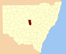
Flinders County is one of the 141 Cadastral divisions of New South Wales. It is located to the south west of the Bogan River.

Flinders County was named in honour of the navigator, hydrographer, and scientist Matthew Flinders (1774-1814).[1]

Parishes within this county

A full list of parishes found within this county; their current LGA and mapping coordinates to the approximate centre of each location is as follows:

Parish LGA Coordinates
Babego Bogan Shire 31°57′54″S 146°32′04″E / 31.96500°S 146.53444°E / -31.96500; 146.53444 (Babego)
Babinda Bogan Shire 31°57′54″S 146°30′04″E / 31.96500°S 146.50111°E / -31.96500; 146.50111 (Babinda)
Balgay Bogan Shire 32°07′54″S 147°00′04″E / 32.13167°S 147.00111°E / -32.13167; 147.00111 (Balgay)
Barrow Bogan Shire 31°51′54″S 146°30′04″E / 31.86500°S 146.50111°E / -31.86500; 146.50111 (Barrow)
Bebri Bogan Shire 31°49′54″S 146°38′04″E / 31.83167°S 146.63444°E / -31.83167; 146.63444 (Bebri)
Belah Lachlan Shire 32°08′54″S 147°10′04″E / 32.14833°S 147.16778°E / -32.14833; 147.16778 (Belah)
Birrigan Bogan Shire 31°37′54″S 146°50′04″E / 31.63167°S 146.83444°E / -31.63167; 146.83444 (Birrigan)
Boree Bogan Shire 31°33′54″S 146°42′04″E / 31.56500°S 146.70111°E / -31.56500; 146.70111 (Boree)
Budgery Bogan Shire 31°33′54″S 146°34′04″E / 31.56500°S 146.56778°E / -31.56500; 146.56778 (Budgery)
Budtha Bogan Shire 32°02′54″S 147°09′04″E / 32.04833°S 147.15111°E / -32.04833; 147.15111 (Budtha)
Bulbodny Lachlan Shire 32°14′54″S 147°10′04″E / 32.24833°S 147.16778°E / -32.24833; 147.16778 (Bulbodny)
Bulga Bogan Shire 31°43′39″S 146°23′59″E / 31.72750°S 146.39972°E / -31.72750; 146.39972 (Bulga)
Bumbaldry Lachlan Shire 32°23′54″S 147°07′04″E / 32.39833°S 147.11778°E / -32.39833; 147.11778 (Bumbaldry)
Burra Lachlan Shire 32°23′54″S 147°00′04″E / 32.39833°S 147.00111°E / -32.39833; 147.00111 (Burra)
Cameron Bogan Shire 32°19′37″S 146°44′07″E / 32.32694°S 146.73528°E / -32.32694; 146.73528 (Cameron)
Condon Bogan Shire 31°45′54″S 146°34′04″E / 31.76500°S 146.56778°E / -31.76500; 146.56778 (Condon)
Coolibah Bogan Shire 31°55′54″S 146°56′04″E / 31.93167°S 146.93444°E / -31.93167; 146.93444 (Coolibah)
Crowie Bogan Shire 31°57′54″S 146°36′04″E / 31.96500°S 146.60111°E / -31.96500; 146.60111 (Crowie)
Cumbine Bogan Shire 32°06′28″S 146°30′25″E / 32.10778°S 146.50694°E / -32.10778; 146.50694 (Cumbine)
Currajong Bogan Shire 32°04′21″S 146°52′02″E / 32.07250°S 146.86722°E / -32.07250; 146.86722 (Currajong)
Delby Bogan Shire 32°15′57″S 146°43′29″E / 32.26583°S 146.72472°E / -32.26583; 146.72472 (Delby)
Egeria Bogan Shire 31°43′54″S 146°30′04″E / 31.73167°S 146.50111°E / -31.73167; 146.50111 (Egeria)
Firbank Bogan Shire 31°53′54″S 146°32′04″E / 31.89833°S 146.53444°E / -31.89833; 146.53444 (Firbank)
Foster Bogan Shire 31°33′54″S 146°46′04″E / 31.56500°S 146.76778°E / -31.56500; 146.76778 (Foster)
Geweroo Bogan Shire 31°38′34″S 146°23′38″E / 31.64278°S 146.39389°E / -31.64278; 146.39389 (Geweroo)
Gilgai Bogan Shire 31°37′54″S 147°01′04″E / 31.63167°S 147.01778°E / -31.63167; 147.01778 (Gilgai)
Gilgai Bogan Shire 31°35′54″S 146°58′04″E / 31.59833°S 146.96778°E / -31.59833; 146.96778 (Gilgai)
Grahway Bogan Shire 32°14′21″S 146°33′05″E / 32.23917°S 146.55139°E / -32.23917; 146.55139 (Grahway)
Grayrigg Bogan Shire 31°39′54″S 146°40′04″E / 31.66500°S 146.66778°E / -31.66500; 146.66778 (Grayrigg)
Hermitage Bogan Shire 31°55′54″S 146°48′04″E / 31.93167°S 146.80111°E / -31.93167; 146.80111 (Hermitage)
Hermitage Plains Bogan Shire 31°53′54″S 146°42′04″E / 31.89833°S 146.70111°E / -31.89833; 146.70111 (Hermitage Plains)
Honeybugle Bogan Shire 31°49′54″S 146°56′04″E / 31.83167°S 146.93444°E / -31.83167; 146.93444 (Honeybugle)
Honeybugle Bogan Shire 31°51′54″S 147°01′04″E / 31.86500°S 147.01778°E / -31.86500; 147.01778 (Honeybugle)
Howgill Bogan Shire 31°47′54″S 146°30′04″E / 31.79833°S 146.50111°E / -31.79833; 146.50111 (Howgill)
Keenan Bogan Shire 31°41′54″S 146°56′04″E / 31.69833°S 146.93444°E / -31.69833; 146.93444 (Keenan)
Keenan Bogan Shire 31°43′54″S 147°02′04″E / 31.73167°S 147.03444°E / -31.73167; 147.03444 (Keenan)
Kinnear Bogan Shire 32°07′56″S 146°43′28″E / 32.13222°S 146.72444°E / -32.13222; 146.72444 (Kinnear)
Lambrigg Bogan Shire 31°39′54″S 146°34′04″E / 31.66500°S 146.56778°E / -31.66500; 146.56778 (Lambrigg)
Merrilba Bogan Shire 31°55′54″S 147°04′04″E / 31.93167°S 147.06778°E / -31.93167; 147.06778 (Merrilba)
Miamley North Lachlan Shire 32°20′52″S 146°54′39″E / 32.34778°S 146.91083°E / -32.34778; 146.91083 (Miamley North)
Miandetta Bogan Shire 31°37′54″S 147°06′04″E / 31.63167°S 147.10111°E / -31.63167; 147.10111 (Miandetta)
Minalong Lachlan Shire 32°18′54″S 147°10′04″E / 32.31500°S 147.16778°E / -32.31500; 147.16778 (Minalong)
Mogille Lachlan Shire 32°18′38″S 146°50′52″E / 32.31056°S 146.84778°E / -32.31056; 146.84778 (Mogille)
Mogille Plain Lachlan Shire 32°20′54″S 147°00′04″E / 32.34833°S 147.00111°E / -32.34833; 147.00111 (Mogille Plain)
Mogundale Lachlan Shire 32°15′04″S 146°51′07″E / 32.25111°S 146.85194°E / -32.25111; 146.85194 (Mogundale)
Mullah Bogan Shire 31°45′54″S 146°36′04″E / 31.76500°S 146.60111°E / -31.76500; 146.60111 (Mullah)
Murrabudda Bogan Shire 31°43′54″S 147°06′04″E / 31.73167°S 147.10111°E / -31.73167; 147.10111 (Murrabudda)
Myall Cowall Bogan Shire 32°02′54″S 147°04′04″E / 32.04833°S 147.06778°E / -32.04833; 147.06778 (Myall Cowall)
Nangerybone Bogan Shire 32°19′57″S 146°35′48″E / 32.33250°S 146.59667°E / -32.33250; 146.59667 (Nangerybone)
Nardoo Bogan Shire 31°41′54″S 146°48′04″E / 31.69833°S 146.80111°E / -31.69833; 146.80111 (Nardoo)
Oberon Lachlan Shire 32°17′54″S 147°03′04″E / 32.29833°S 147.05111°E / -32.29833; 147.05111 (Oberon)
Pangee Bogan Shire 31°57′54″S 146°42′04″E / 31.96500°S 146.70111°E / -31.96500; 146.70111 (Pangee)
Pangee Creek Bogan Shire 31°49′54″S 146°46′04″E / 31.83167°S 146.76778°E / -31.83167; 146.76778 (Pangee Creek)
Quanda Bogan Shire 31°43′54″S 146°42′04″E / 31.73167°S 146.70111°E / -31.73167; 146.70111 (Quanda)
Quondong Bogan Shire 31°45′54″S 146°52′04″E / 31.76500°S 146.86778°E / -31.76500; 146.86778 (Quondong)
Red Gilgais Bogan Shire 31°57′54″S 146°56′04″E / 31.96500°S 146.93444°E / -31.96500; 146.93444 (Red Gilgais)
Red Gilgais Bogan Shire 32°01′54″S 147°00′04″E / 32.03167°S 147.00111°E / -32.03167; 147.00111 (Red Gilgais)
Regan Bogan Shire 31°51′54″S 146°52′04″E / 31.86500°S 146.86778°E / -31.86500; 146.86778 (Regan)
Talgong Bogan Shire 32°10′30″S 146°52′11″E / 32.17500°S 146.86972°E / -32.17500; 146.86972 (Talgong)
The Bluff Lachlan Shire 32°27′42″S 146°53′02″E / 32.46167°S 146.88389°E / -32.46167; 146.88389 (The Bluff)
The Overflow Bogan Shire 32°12′05″S 146°38′31″E / 32.20139°S 146.64194°E / -32.20139; 146.64194 (The Overflow)
Umang Bogan Shire 32°07′54″S 147°04′04″E / 32.13167°S 147.06778°E / -32.13167; 147.06778 (Umang)
Walkers Hill Bogan Shire 32°23′45″S 146°47′29″E / 32.39583°S 146.79139°E / -32.39583; 146.79139 (Walkers Hill)
Walton Bogan Shire 32°10′26″S 146°34′16″E / 32.17389°S 146.57111°E / -32.17389; 146.57111 (Walton)
Walwa Bogan Shire 32°06′04″S 146°36′55″E / 32.10111°S 146.61528°E / -32.10111; 146.61528 (Walwa)
Wharfdale Bogan Shire 32°12′54″S 147°02′04″E / 32.21500°S 147.03444°E / -32.21500; 147.03444 (Wharfdale)
Wharfdale North Bogan Shire 32°11′33″S 146°57′19″E / 32.19250°S 146.95528°E / -32.19250; 146.95528 (Wharfdale North)
Whitbarrow Bogan Shire 31°33′54″S 146°50′04″E / 31.56500°S 146.83444°E / -31.56500; 146.83444 (Whitbarrow)
Wicklow Bogan Shire 31°57′54″S 146°58′04″E / 31.96500°S 146.96778°E / -31.96500; 146.96778 (Wicklow)
Wicklow Bogan Shire 31°59′54″S 147°00′04″E / 31.99833°S 147.00111°E / -31.99833; 147.00111 (Wicklow)
Widgeland Bogan Shire 31°49′54″S 147°02′04″E / 31.83167°S 147.03444°E / -31.83167; 147.03444 (Widgeland)
Wilmatha Lachlan Shire 32°27′54″S 147°03′04″E / 32.46500°S 147.05111°E / -32.46500; 147.05111 (Wilmatha)
Winfell Bogan Shire 31°39′54″S 146°30′04″E / 31.66500°S 146.50111°E / -31.66500; 146.50111 (Winfell)
Yamma Bogan Shire 31°37′54″S 146°44′04″E / 31.63167°S 146.73444°E / -31.63167; 146.73444 (Yamma)
Yarrow Bogan Shire 31°55′54″S 146°36′04″E / 31.93167°S 146.60111°E / -31.93167; 146.60111 (Yarrow)
Yoongee Bogan Shire 31°33′54″S 146°30′04″E / 31.56500°S 146.50111°E / -31.56500; 146.50111 (Yoongee)

References

  1. ^ "Flinders County". Geographical Names Register (GNR) of NSW. Geographical Names Board of New South Wales. Edit this at Wikidata
This page was last edited on 23 June 2020, at 19:43
Basis of this page is in Wikipedia. Text is available under the CC BY-SA 3.0 Unported License. Non-text media are available under their specified licenses. Wikipedia® is a registered trademark of the Wikimedia Foundation, Inc. WIKI 2 is an independent company and has no affiliation with Wikimedia Foundation.