

Size of this PNG preview of this SVG file: 523 × 600 pixels. Other resolutions: 209 × 240 pixels | 418 × 480 pixels | 670 × 768 pixels | 893 × 1,024 pixels | 1,786 × 2,048 pixels | 667 × 765 pixels.
Original file (SVG file, nominally 667 × 765 pixels, file size: 66 KB)
| This is a file from the Wikimedia Commons. Information from its description page there is shown below. Commons is a freely licensed media file repository. You can help. |
Summary
| Description |
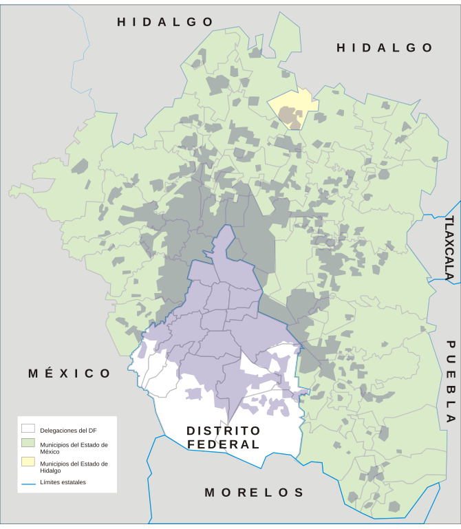
Español: Mapa de la Zona Metropolitana del Valle de México, que se extiende en su totalidad por el estado de Ciudad de México (16 demarcaciones), así como por parte de los estados de México (59 municipios) e Hidalgo (un municipio). |
| Date | 14 June 2006 (original upload date) |
| Source | No machine-readable source provided. Own work assumed (based on copyright claims). |
| Author | No machine-readable author provided. Yavidaxiu assumed (based on copyright claims). |
| SVG development |
Licensing
| I, the copyright holder of this work, release this work into the public domain. This applies worldwide. In some countries this may not be legally possible; if so: I grant anyone the right to use this work for any purpose, without any conditions, unless such conditions are required by law. |
File history
Click on a date/time to view the file as it appeared at that time.
| Date/Time | Thumbnail | Dimensions | User | Comment | |
|---|---|---|---|---|---|
| current | 13:52, 14 June 2006 | | 667 × 765 (66 KB) | Yavidaxiu | Mapa de la zona urbana de la Zona Metropolitana de la Ciudad de México. Incluye un municipio del estado de Hidalgo (en amarillo), 59 del estado de México (en verde) y las 16 delegaciones del Distrito Federal (en blanco). |
| 13:44, 14 June 2006 |  | 990 × 765 (66 KB) | Yavidaxiu | Mapa de la Zona Metropolitana de la Ciudad de México. | |
| 13:41, 14 June 2006 |  | 990 × 765 (69 KB) | Yavidaxiu | Mapa de la zona urbana de la Zona Metropolitana de la Ciudad de México Category:Maps of México |
File usage
The following pages on the English Wikipedia use this file (pages on other projects are not listed):
Global file usage
The following other wikis use this file:
- Usage on af.wikipedia.org
- Usage on an.wikipedia.org
- Usage on ast.wikipedia.org
- Usage on ba.wikipedia.org
- Usage on ca.wikipedia.org
- Usage on cs.wikipedia.org
- Usage on de.wikipedia.org
- Usage on el.wikipedia.org
- Usage on es.wikipedia.org
- Usage on es.wiktionary.org
- Usage on fr.wikipedia.org
- Usage on hr.wikipedia.org
- Usage on id.wikipedia.org
- Usage on it.wikipedia.org
- Usage on jbo.wikipedia.org
- Usage on ka.wikipedia.org
- Usage on la.wikipedia.org
- Usage on lez.wikipedia.org
- Usage on ms.wikipedia.org
- Usage on mt.wikipedia.org
- Usage on nl.wikipedia.org
- Usage on no.wikipedia.org
- Usage on pl.wikipedia.org
- Usage on pt.wikipedia.org
- Usage on roa-tara.wikipedia.org
- Usage on sco.wikipedia.org
- Usage on simple.wikipedia.org
- Usage on sv.wikipedia.org
- Usage on tr.wikipedia.org
- Usage on vep.wikipedia.org
- Usage on vi.wikipedia.org
- Usage on zh.wikipedia.org