
Size of this preview: 800 × 397 pixels. Other resolutions: 320 × 159 pixels | 640 × 318 pixels | 1,024 × 508 pixels | 1,280 × 635 pixels | 2,560 × 1,271 pixels | 4,500 × 2,234 pixels.
Original file (4,500 × 2,234 pixels, file size: 401 KB, MIME type: image/png)
| This is a file from the Wikimedia Commons. Information from its description page there is shown below. Commons is a freely licensed media file repository. You can help. |

|
This map has been uploaded by Electionworld from en.wikipedia.org to enable the |
Summary
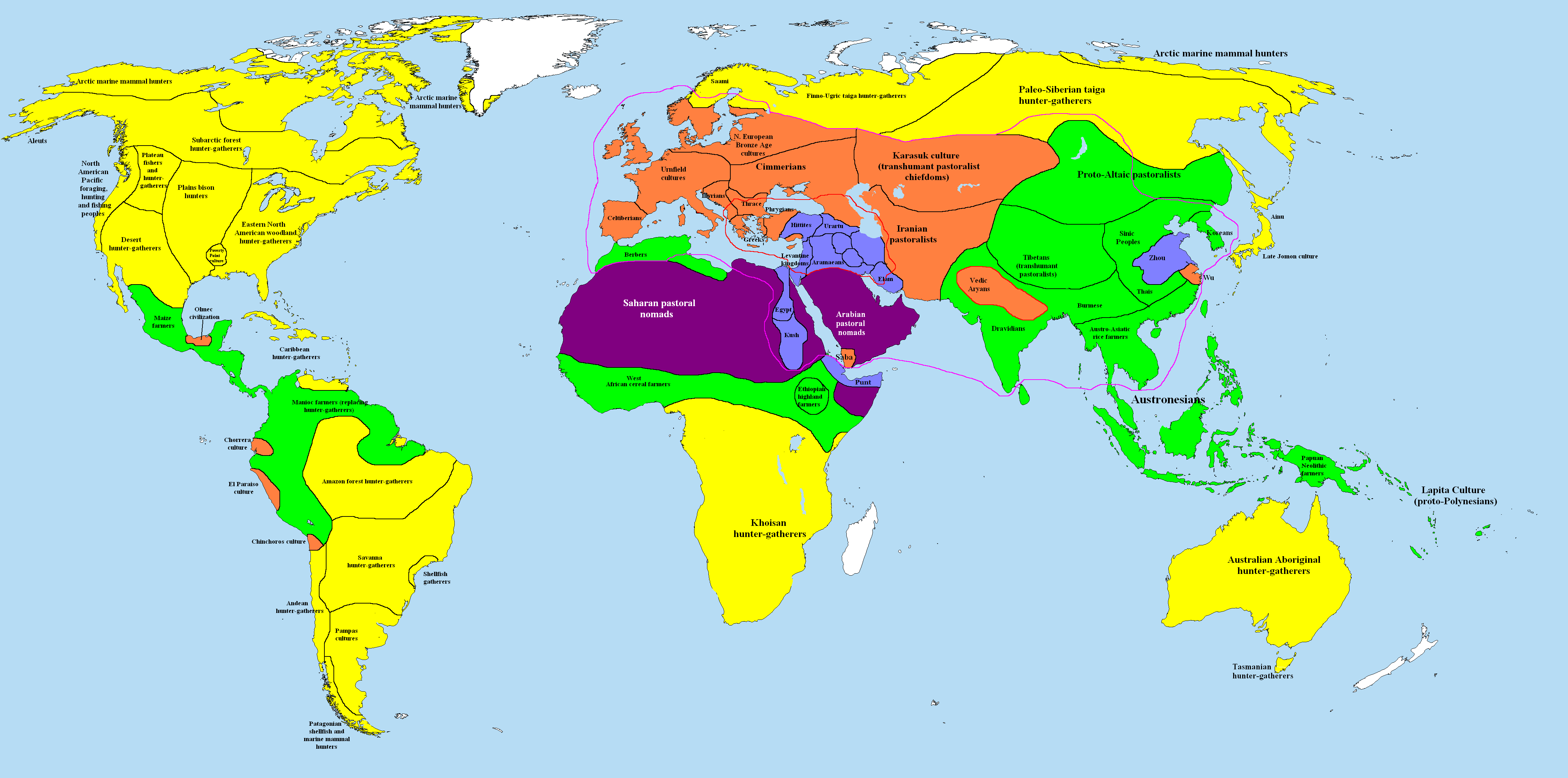
The world, c. 1000 BC.

|
This historical map image could be re-created using vector graphics as an SVG file. This has several advantages; see Commons:Media for cleanup for more information. If an SVG form of this image is available, please upload it and afterwards replace this template with
{{vector version available|new image name}}.
It is recommended to name the SVG file “World in 1000 BCE.svg”—then the template Vector version available (or Vva) does not need the new image name parameter. |
Key
uninhabited
Area of iron working, c. 1000 BC.
Area of bronze working, c. 1000 BC.
| Previous: 2000 BCE |
Category:World history map series by User:Briangotts |
Next: 500 BCE |
Reference
- Haywood, John, et al. The Cassell Atlas of World History. Andromeda Oxford Ltd., 1997. p. 1.05.
| Maps of world history | |
| BC | |
|
| |
| AD |
1 · 50 · 100 · 200 · 250 · 300 · 400 · 500 · 700 · 750 · 820 · 900 · 1200 · 1500 · 1556 · 1648 · 1700 · 1750 · 1815 · 1859 · 1871 · 1914 · 1935 · 1954 · 1989 · 2000 · |
|
Maps of colonization history | |
|
see also: Eastern Hemisphere only maps template (1300BC-1500AD) | |
| (this template: · view · discuss ) | |
Licensing
I, the copyright holder of this work, hereby publish it under the following licenses:

|
Permission is granted to copy, distribute and/or modify this document under the terms of the GNU Free Documentation License, Version 1.2 or any later version published by the Free Software Foundation; with no Invariant Sections, no Front-Cover Texts, and no Back-Cover Texts. A copy of the license is included in the section entitled GNU Free Documentation License. |
| This file is licensed under the Creative Commons Attribution-Share Alike 3.0 Unported license. | ||
| ||
| This licensing tag was added to this file as part of the GFDL licensing update. |
This file is licensed under the Creative Commons Attribution 2.5 Generic license.
- You are free:
- to share – to copy, distribute and transmit the work
- to remix – to adapt the work
- Under the following conditions:
- attribution – You must give appropriate credit, provide a link to the license, and indicate if changes were made. You may do so in any reasonable manner, but not in any way that suggests the licensor endorses you or your use.
You may select the license of your choice.
Other versions

.jpg)
._LOC_2001620596.jpg)
File history
Click on a date/time to view the file as it appeared at that time.
| Date/Time | Thumbnail | Dimensions | User | Comment | |
|---|---|---|---|---|---|
| current | 10:59, 28 September 2023 | | 4,500 × 2,234 (401 KB) | <bdi>Notradeuussrs</bdi> | add Punt |
| 09:33, 3 April 2021 |  | 4,500 × 2,234 (400 KB) | Glennznl | Reverted to version as of 23:12, 31 October 2020 (UTC) Completely unsourced, the Igorot society article has been deleted from Wikipedia as it is a hoax | |
| 02:55, 27 March 2021 |  | 4,500 × 2,234 (584 KB) | <bdi>Enola gay0</bdi> | Reverted to version as of 04:31, 24 May 2019 (UTC) Banaue rice terraces | |
| 23:12, 31 October 2020 |  | 4,500 × 2,234 (400 KB) | Glennznl | Reverted to version as of 12:40, 4 May 2016 (UTC) | |
| 04:31, 24 May 2019 |  | 4,500 × 2,234 (584 KB) | <bdi>Enola gay0</bdi> | Reverted to version as of 07:52, 3 June 2017 (UTC) | |
| 15:09, 2 August 2017 |  | 4,500 × 2,234 (400 KB) | Gunkarta | Reverted to version as of 12:40, 4 May 2016 (UTC) | |
| 07:52, 3 June 2017 |  | 4,500 × 2,234 (584 KB) | Theseeker2016 | bold-type caption. | |
| 02:54, 3 June 2017 |  | 4,500 × 2,234 (583 KB) | Theseeker2016 | Add descriptions. | |
| 12:26, 2 June 2017 |  | 4,500 × 2,234 (397 KB) | Theseeker2016 | Although there is some evidence early Austronesian migrants having bronze or brass tools,<ref>{{cite book|last1=Manansala|first1=Paul|title=Quests of the Dragon and Bird Clan|pages=324}}</ref><ref>{{cite web|last1=Thiel|first1=Barbara|title=Excavations... | |
| 12:40, 4 May 2016 |  | 4,500 × 2,234 (400 KB) | Philip Stevens | Falklands were uninhabited |
File usage
The following pages on the English Wikipedia use this file (pages on other projects are not listed):
Global file usage
The following other wikis use this file:
- Usage on ar.wikipedia.org
- Usage on ast.wikipedia.org
- Usage on as.wikipedia.org
- Usage on az.wikipedia.org
- Usage on bg.wikipedia.org
- Usage on bn.wikipedia.org
- Usage on ca.wikipedia.org
- Usage on cs.wikipedia.org
- Usage on da.wikipedia.org
- Usage on de.wikipedia.org
- Usage on el.wikipedia.org
- Usage on es.wikipedia.org
- Usage on fa.wikipedia.org
- Usage on fr.wikipedia.org
- Usage on gl.wikipedia.org
- Usage on he.wikipedia.org
- Usage on hu.wikipedia.org
- Usage on hy.wikipedia.org
- Usage on id.wikipedia.org
- Usage on ie.wikipedia.org
- Usage on io.wikipedia.org
- Usage on it.wikipedia.org
- Usage on ja.wikipedia.org
- Usage on ka.wikipedia.org
- Usage on la.wikipedia.org
- Usage on lij.wikipedia.org
- Usage on lt.wikipedia.org
- Usage on mk.wikipedia.org
- Usage on ms.wikipedia.org
- Usage on nl.wikipedia.org
View more global usage of this file.