
No higher resolution available.
Water_Level_Route_on_US_map_cropped.png (675 × 466 pixels, file size: 176 KB, MIME type: image/png)
| This is a file from the Wikimedia Commons. Information from its description page there is shown below. Commons is a freely licensed media file repository. You can help. |
Summary
| Description |
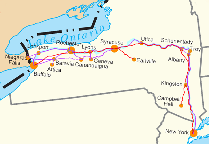
Water Level Routes of the New York Central Railroad, West Shore Railroad and Erie Canal on Image:US state outline map.png. See Image:Water Level Route on US map.png for the full U.S. |
| Date | |
| Source | Own work |
| Author | SPUI |
| Other versions | Image:Water Level Route on US map.png - uncropped version. |

|
This transport map image could be re-created using vector graphics as an SVG file. This has several advantages; see Commons:Media for cleanup for more information. If an SVG form of this image is available, please upload it and afterwards replace this template with
{{vector version available|new image name}}.
It is recommended to name the SVG file “Water Level Route on US map cropped.svg”—then the template Vector version available (or Vva) does not need the new image name parameter. |
Licensing
| This work has been released into the public domain by its author, SPUI. This applies worldwide. In some countries this may not be legally possible; if so: |
File history
Click on a date/time to view the file as it appeared at that time.
| Date/Time | Thumbnail | Dimensions | User | Comment | |
|---|---|---|---|---|---|
| current | 17:23, 2 July 2018 | | 675 × 466 (176 KB) | Ɱ | toning colors |
| 19:45, 3 July 2005 |  | 679 × 358 (27 KB) | <bdi>SPUI~commonswiki</bdi> | {{spuimap}} Water Level Routes of the New York Central Railroad, West Shore Railroad and Erie Canal on Image:US state outline map.png. See Image:Water Level Route on US map.png for the full U.S. category:New York Central Railroad [[categor |
File usage
The following pages on the English Wikipedia use this file (pages on other projects are not listed):
Global file usage
The following other wikis use this file:
- Usage on az.wikipedia.org
- Usage on ba.wikipedia.org
- Usage on fr.wikipedia.org
- Usage on ga.wikipedia.org
- Usage on he.wikipedia.org
- Usage on ja.wikipedia.org
- Usage on mk.wikipedia.org
- Usage on pt.wikipedia.org
- Usage on ro.wikipedia.org
- Usage on ru.wikipedia.org
- Usage on sv.wikipedia.org
- Usage on tr.wikipedia.org
- Usage on uk.wikipedia.org