

Size of this PNG preview of this SVG file: 427 × 599 pixels. Other resolutions: 171 × 240 pixels | 342 × 480 pixels | 547 × 768 pixels | 729 × 1,024 pixels | 1,459 × 2,048 pixels | 570 × 800 pixels.
Original file (SVG file, nominally 570 × 800 pixels, file size: 79 KB)
| This is a file from the Wikimedia Commons. Information from its description page there is shown below. Commons is a freely licensed media file repository. You can help. |
Summary
| Description |
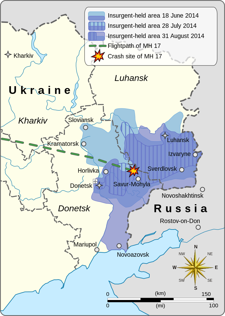
This is a map of the War in Donbass. It shows the expansion and contraction of pro-Russian insurgent-held areas over the duration of the conflict, starting with 18 June 2014, then as of 28 July, and finally as of 31 August. It also depicts the flightpath and crash-site of Malaysia Airlines Flight 17.
|
||||||||||||||||||||||||||||||||||
| Date | |||||||||||||||||||||||||||||||||||
| Source |
Own work based on: Europe laea location map.svg
|
||||||||||||||||||||||||||||||||||
| Author | Goran tek-en | ||||||||||||||||||||||||||||||||||
| Permission (Reusing this file) |
This file is licensed under the Creative Commons Attribution-Share Alike 4.0 International license. Attribution: Goran tek-en
|
||||||||||||||||||||||||||||||||||
| Other versions |
|
||||||||||||||||||||||||||||||||||
| SVG development | This vector image was created with Inkscape. |
||||||||||||||||||||||||||||||||||


.svg)
| Object location | | View this and other nearby images on: OpenStreetMap |
|---|


File history
Click on a date/time to view the file as it appeared at that time.
| Date/Time | Thumbnail | Dimensions | User | Comment | |
|---|---|---|---|---|---|
| current | 19:11, 5 December 2021 | | 570 × 800 (79 KB) | Goran tek-en | ppi to 96, optimized |
| 10:14, 15 January 2015 |  | 570 × 800 (140 KB) | Goran tek-en | corrected spelling, corrected area of 31 August | |
| 04:50, 14 January 2015 |  | 570 × 800 (139 KB) | RGloucester | Reverted to version as of 16:17, 24 November 2014 | |
| 02:10, 25 November 2014 |  | 570 × 800 (140 KB) | Mondolkiri1 | Horlivka was never reconquered by the Ukrainian govt. If some correction shall be done about previous military positions, they should be around Lugansk, not Horlivks. | |
| 16:17, 24 November 2014 |  | 570 × 800 (139 KB) | Goran tek-en | User created page with UploadWizard |
File usage
The following pages on the English Wikipedia use this file (pages on other projects are not listed):
Global file usage
The following other wikis use this file:
- Usage on bg.wikipedia.org
- Usage on da.wikipedia.org
- Usage on de.wikipedia.org
- Usage on el.wikipedia.org
- Usage on et.wikipedia.org
- Usage on eu.wikipedia.org
- Usage on ga.wikipedia.org
- Usage on he.wikipedia.org
- Usage on id.wikipedia.org
- Usage on kk.wikipedia.org
- Usage on ko.wikipedia.org
- Usage on lv.wikipedia.org
- Usage on ro.wikipedia.org
- Usage on ru.wikipedia.org
- Usage on sc.wikipedia.org
- Usage on sk.wikipedia.org
- Usage on so.wikipedia.org
- Usage on sr.wikipedia.org