

Size of this preview: 472 × 599 pixels. Other resolutions: 189 × 240 pixels | 378 × 480 pixels | 916 × 1,162 pixels.
Original file (916 × 1,162 pixels, file size: 96 KB, MIME type: image/png)
| This is a file from the Wikimedia Commons. Information from its description page there is shown below. Commons is a freely licensed media file repository. You can help. |
Summary
| Description |
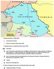
Vojvodina from October 1944 to April 1945 - territory of Military Administration in Banat, Bačka and Baranja and Syrmian frontline.
|
| Date | 29 June 2009 (original upload date) |
| Source | No machine-readable source provided. Own work assumed (based on copyright claims). |
| Author | No machine-readable author provided. PANONIAN assumed (based on copyright claims). |
Licensing
self made map by user:PANONIAN
| I, the copyright holder of this work, release this work into the public domain. This applies worldwide. In some countries this may not be legally possible; if so: I grant anyone the right to use this work for any purpose, without any conditions, unless such conditions are required by law. |
References
- Nikola Gaćeša - Dušan Živković - Ljubica Radović, Istorija za III razred gimnazije prirodno-matematičkog smera i IV razred gimnazije opšteg i društveno-jezičkog smera, Beograd, 1997.
- Jelena Popov, Vojvodina i Srbija, Veternik, 2001.
- Dimitrije Boarov, Politička istorija Vojvodine, Novi Sad, 2001.
- Dragomir Jankov, Vojvodina - propadanje jednog regiona, Novi Sad, 2004.
- Istorijski atlas, Geokarta, Beograd, 1999.
- Školski istorijski atlas, Zavod za izdavanje udžbenika SR Srbije, Beograd, 1970.
- Povijesni atlas, Učila - Zagreb, Zagreb, 1971.
- Povijesni atlas za osnovnu školu, Kartografija - Tlos - Zagreb, Zagreb, 1975.
- Denis Šehić - Demir Šehić, Istorijski atlas sveta, Beograd, 2007.
- Istorijski atlas, Intersistem kartografija, Beograd, 2010.
File history
Click on a date/time to view the file as it appeared at that time.
| Date/Time | Thumbnail | Dimensions | User | Comment | |
|---|---|---|---|---|---|
| current | 21:20, 5 June 2014 | | 916 × 1,162 (96 KB) | PANONIAN | date change |
| 13:44, 10 December 2011 |  | 916 × 1,162 (96 KB) | PANONIAN | aesthetics | |
| 21:29, 29 June 2009 |  | 916 × 1,162 (96 KB) | PANONIAN | ==Description== * '''English''': Vojvodina from October 1944 to April 1945 - territory of Military Administration in Banat, Bačka and Baranja and Syrmian frontline. * '''Serbian''': Војводина од октобра 1944. до априла 1945. г� |
File usage
The following pages on the English Wikipedia use this file (pages on other projects are not listed):
Global file usage
The following other wikis use this file:
- Usage on bg.wikipedia.org
- Usage on ja.wikipedia.org
- Usage on ru.wikipedia.org
- Usage on sh.wikipedia.org
- Usage on sv.wikipedia.org
- Usage on uk.wikipedia.org
- Usage on vi.wikipedia.org