

Original file (1,024 × 818 pixels, file size: 318 KB, MIME type: image/jpeg)
| This is a file from the Wikimedia Commons. Information from its description page there is shown below. Commons is a freely licensed media file repository. You can help. |
Summary
| Description |
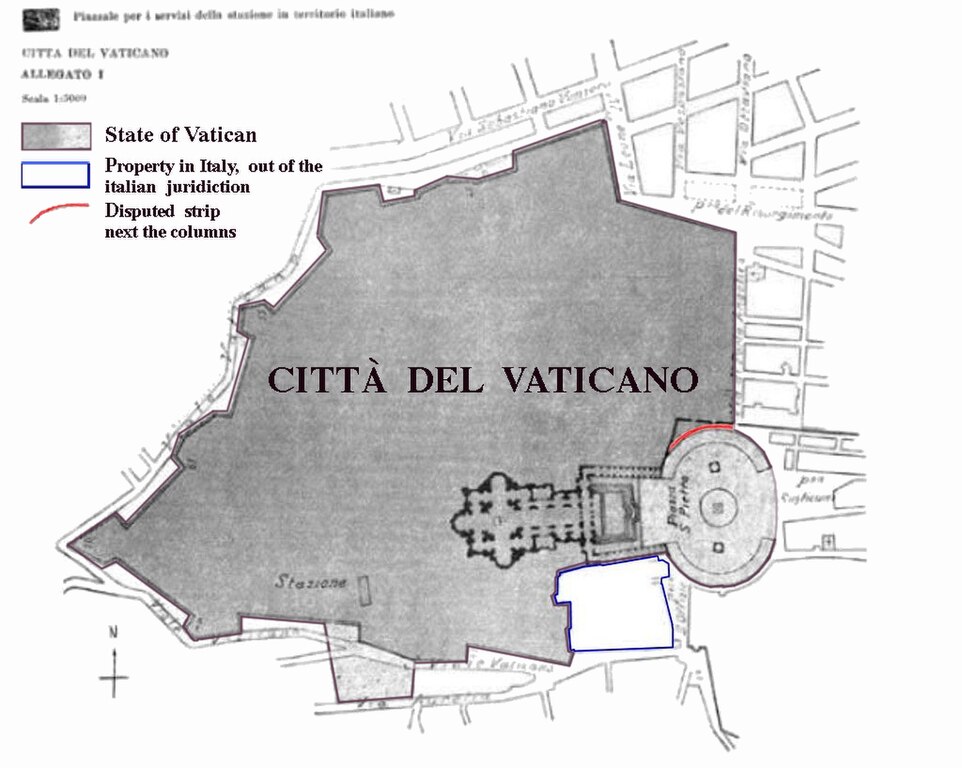
Boundary map taken from the annex of the Lateran treaties. Colored areas are modifications of original image for purposes of clarification.
|
| Date | |
| Source | Annex of the Lateran Treaty |
| Author | Original: de:Bild:Vatikanstadt_Annex.jpg, amended by gugganij |

|
This map has been uploaded by Electionworld from en.wikipedia.org to enable the |
Licensing
|
This work is in the public domain in its country of origin and other countries and areas where the copyright term is the author's life plus 70 years or fewer.
| |
| This file has been identified as being free of known restrictions under copyright law, including all related and neighboring rights. | |
Original upload log
- 2010-05-16 01:43 Saibo 2283×2098× (1084697 bytes) gedreht (Einnordung) und Legendenelemente verschoben und Untertitel gelöscht
- 2004-07-30 13:23 Gugganij 2104×2625× (219537 bytes) verkleinert (noch ein Versuch)
- 2004-07-30 13:21 Gugganij 2104×2625× (219537 bytes) verkleinert
- 2004-07-26 14:32 Gugganij 2104×2625× (219571 bytes) verkleinert
- 2004-07-26 14:04 Gugganij 2104×2625× (262857 bytes) Karte der Vatikanstadt (aus dem [[Annex]] der [[Lateranverträge]]), [[Public domain]], bearbeitet von [[Benutzer:gugganij|gugganij]]
File history
Click on a date/time to view the file as it appeared at that time.
| Date/Time | Thumbnail | Dimensions | User | Comment | |
|---|---|---|---|---|---|
| current | 16:51, 25 July 2014 | | 1,024 × 818 (318 KB) | Spiridon Ion Cepleanu | New version with legend |
| 12:00, 1 April 2011 |  | 2,096 × 2,625 (261 KB) | Rotatebot | Bot: Rotate 90° | |
| 22:37, 20 December 2006 |  | 2,625 × 2,104 (261 KB) | Electionworld | {{ew|en|El Suizo}} *Description: Boundary map taken from the annex of the lateran treaties. Colored areas are modifications of original image for purposes of clarification. *Source: German Wikipedia ==Details== * '''dark grey''': territory of Vatican Cit |
File usage
Global file usage
The following other wikis use this file:
- Usage on af.wikipedia.org
- Usage on an.wikipedia.org
- Usage on ar.wikipedia.org
- Usage on ast.wikipedia.org
- Usage on ba.wikipedia.org
- Usage on bcl.wikipedia.org
- Usage on be-tarask.wikipedia.org
- Usage on be.wikipedia.org
- Usage on bg.wikipedia.org
- Usage on bn.wikipedia.org
- Usage on bn.wikibooks.org
- Usage on ca.wikipedia.org
- Usage on cs.wikipedia.org
- Usage on cy.wikipedia.org
- Usage on el.wikipedia.org
- Usage on es.wikipedia.org
- Usage on et.wikipedia.org
- Usage on fa.wikipedia.org
- Usage on fi.wikipedia.org
- Usage on fr.wikipedia.org
- Usage on gd.wikipedia.org
- Usage on he.wikipedia.org
- Usage on hr.wikipedia.org
- Usage on hu.wikipedia.org
- Usage on hy.wikipedia.org
- Usage on id.wikipedia.org
View more global usage of this file.