

Size of this preview: 800 × 534 pixels. Other resolutions: 320 × 214 pixels | 640 × 427 pixels | 1,024 × 683 pixels | 1,500 × 1,001 pixels.
Original file (1,500 × 1,001 pixels, file size: 623 KB, MIME type: image/jpeg)
| This is a file from the Wikimedia Commons. Information from its description page there is shown below. Commons is a freely licensed media file repository. You can help. |
| Description |
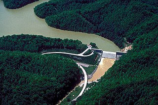
Aerial view of Martins Fork Dam and Lake on the Martins Fork branch of the Cumberland River in Harlan County, Kentucky, USA. The U.S. Army Corps of Engineers constructed the dam for water storage and flood control between 1973–1978. The project was completed and the lake was impounded in December 1978. The dam is 97 feet (30 m) high and 504 feet (154 m) wide. There is no hydroelectric power plant at the dam. |
|||
| Date | not specified or unknown | |||
| Source |
U.S. Army Corps of Engineers Digital Visual Library Image page Image description page Digital Visual Library home page |
|||
| Author | George Green, U.S. Army Corps of Engineers | |||
| Permission (Reusing this file) |
|
| Camera location | | View this and other nearby images on: OpenStreetMap |
|---|
File history
Click on a date/time to view the file as it appeared at that time.
| Date/Time | Thumbnail | Dimensions | User | Comment | |
|---|---|---|---|---|---|
| current | 19:50, 25 March 2007 | | 1,500 × 1,001 (623 KB) | DanMS | {{Information | Description = {{en|Aerial view of Martins Fork Dam and Lake on the Martins Fork branch of the Cumberland River in Harlan County, Kentucky, USA. The U.S. Army Corps of Engineers constructed the dam for water storage and flood control bet |
File usage
The following pages on the English Wikipedia use this file (pages on other projects are not listed):
Global file usage
The following other wikis use this file:
- Usage on ceb.wikipedia.org
- Usage on www.wikidata.org